- Columbia County, Wisconsin
-
Columbia County, Wisconsin 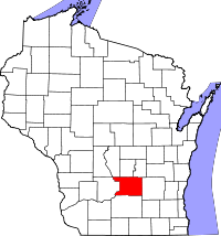
Location in the state of Wisconsin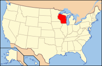
Wisconsin's location in the U.S.Founded 1854 Seat Portage Area
- Total
- Land
- Water
796 sq mi (2,062 km²)
774 sq mi (2,005 km²)
22 sq mi (57 km²), 2.75%Population
- (2000)
- Density
52,468
67/sq mi (26/km²)Website www.co.columbia.wi.us Columbia County is a county located in the U.S. state of Wisconsin. As of 2000, the population was 52,468. Its county seat and largest city is Portage.[1]
Columbia County is part of the Madison Metropolitan Statistical Area.
Contents
Geography
According to the U.S. Census Bureau, the county has a total area of 796 square miles (2,061.6 km2), of which 774 square miles (2,004.7 km2) is land and 22 square miles (57.0 km2) (2.75%) is water. The county's highest point is Gibraltar Rock at 1,247 feet above sea level. The high butte-shaped bluff is located north of Lodi overlooking the Lake Wisconsin River valley.
Major highways
 Interstate 39
 Interstate 90
 Interstate 94
 U.S. Highway 51
 U.S. Highway 151
 Highway 13 (Wisconsin)
 Highway 16 (Wisconsin)
 Highway 22 (Wisconsin)
 Highway 23 (Wisconsin)
 Highway 33 (Wisconsin)
 Highway 44 (Wisconsin)
 Highway 60 (Wisconsin)
 Highway 73 (Wisconsin)
 Highway 78 (Wisconsin)
 Highway 89 (Wisconsin)
 Highway 127 (Wisconsin)
 Highway 146 (Wisconsin)
 Highway 113 (Wisconsin)
 Highway 188 (Wisconsin)
Adjacent counties
- Marquette County – north
- Green Lake County – northeast
- Dodge County – east
- Dane County – south
- Sauk County – west
- Juneau County – northwest
- Adams County – northwest
Demographics
 2000 Census Age Pyramid for Columbia County.
Historical populations Census Pop. %± 1900 31,121 — 1910 31,129 0% 1920 30,468 −2.1% 1930 30,503 0.1% 1940 32,517 6.6% 1950 34,023 4.6% 1960 36,708 7.9% 1970 40,150 9.4% 1980 43,222 7.7% 1990 45,088 4.3% 2000 52,468 16.4% 2010 56,833 8.3% WI Counties 1900-1990 As of the census[2] of 2000, there were 52,468 people, 20,439 households, and 14,164 families residing in the county. The population density was 68 people per square mile (26/km²). There were 22,685 housing units at an average density of 29 per square mile (11/km²). The racial makeup of the county was 97.18% White, 0.88% Black or African American, 0.35% Native American, 0.33% Asian, 0.02% Pacific Islander, 0.44% from other races, and 0.79% from two or more races. 1.58% of the population were Hispanic or Latino of any race. 46.4% were of German, 10.2% Norwegian, 7.8% Irish, 6.4% English and 5.0% United States or American ancestry.
There were 20,439 households out of which 32.20% had children under the age of 18 living with them, 58.10% were married couples living together, 7.40% had a female householder with no husband present, and 30.70% were non-families. 25.50% of all households were made up of individuals and 11.00% had someone living alone who was 65 years of age or older. The average household size was 2.49 and the average family size was 2.99.
In the county, the population was spread out with 25.20% under the age of 18, 7.10% from 18 to 24, 29.90% from 25 to 44, 23.40% from 45 to 64, and 14.40% who were 65 years of age or older. The median age was 38 years. For every 100 females there were 101.60 males. For every 100 females age 18 and over, there were 100.40 males.
Cities, villages, and towns
- Arlington (town)
- Arlington (village)
- Caledonia (town)
- Cambria (village)
- Columbus (city)
- Columbus (town)
- Courtland (town)
- Dekorra (town)
- Doylestown (village)
- Fall River (village)
- Fort Winnebago (town)
- Fountain Prairie (town)
- Friesland (village)
- Hampden (town)
- Leeds (town)
- Lewiston (town)
- Lodi (town)
- Lodi (city)
- Lowville (town)
- Marcellon (town)
- Newport (town)
- Otsego (town)
- Pacific (town)
- Pardeeville (village)
- Portage (city)
- Poynette (village)
- Randolph (town)
- Randolph (village) (partial)
- Rio (village)
- Scott (town)
- Springvale (town)
- West Point (town)
- Wisconsin Dells (city) (partial)
- Wyocena (town)
- Wyocena (village)
Unincorporated communities
 Columbia County Law Enforcement Center
- Anacker
- Belle Fountain
- Durwards Glen
- East Friesland
- Harmony Grove
- Ingle
- Keyeser
- Lake Wisconsin
- Leeds
- Lowville
- Marcellon
- North Leeds
- Okee
- Otsego
See also
References
- ^ "Find a County". National Association of Counties. http://www.naco.org/Counties/Pages/FindACounty.aspx. Retrieved 2011-06-07.
- ^ "American FactFinder". United States Census Bureau. http://factfinder.census.gov. Retrieved 2008-01-31.
External links
- Columbia County government website
- History of Columbia County, Wisconsin
- Memorial and Biographical Record and Illustrated Compendium of Biography ... of Columbia, Sauk and Adams counties, Wisconsin...

Adams County and Juneau County Marquette County Green Lake County Sauk County 
Dodge County  Columbia County, Wisconsin

Dane County Municipalities and communities of Columbia County, Wisconsin Cities Columbus‡ | Lodi | Portage | Wisconsin Dells‡

Villages Arlington | Cambria | Doylestown | Fall River | Friesland | Pardeeville | Poynette | Randolph‡ | Rio | Wyocena
Towns CDP Unincorporated
communitiesAnacker | Belle Fountain | Durwards Glen | East Friesland | Harmony Grove | Ingle | Keyeser | Leeds | Lowville | Marcellon | North Leeds | Okee | Otsego
Footnotes ‡This populated place also has portions in an adjacent county or counties
Categories:- Wisconsin counties
- Columbia County, Wisconsin
- 1854 establishments in the United States
- Madison metropolitan area


Wikimedia Foundation. 2010.