- Jesmond, New South Wales
-
Jesmond
Newcastle, New South Wales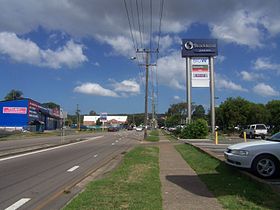
Blue Gum Road, Jesmond, location of
Stockland Jesmond Shopping Centre.
 Jesmond
Population: 2,441[1] • Density: 1877.7/km² (4,863.2/sq mi) Postcode: 2299 Coordinates: 32°54′13″S 151°41′39″E / 32.90361°S 151.69417°ECoordinates: 32°54′13″S 151°41′39″E / 32.90361°S 151.69417°E Area: 1.3 km² (0.5 sq mi) [Note 1] Time zone: • Summer (DST)
AEST (UTC+10) AEDT (UTC+11)
Location: LGA: City of Newcastle[2] Region: Hunter[2] County: Northumberland[3] Parish: Newcastle[3] State District: Wallsend[4] Federal Division: Suburbs around Jesmond: Birmingham Gardens Birmingham Gardens Callaghan Wallsend Jesmond North Lambton Wallsend Wallsend Lambton Jesmond is a suburb of the City of Newcastle LGA, located about 9.5 km (6 mi) west of the Newcastle CBD in the Hunter Region of New South Wales, Australia.[2][7] It is both a commercial centre and residential area catering to Newcastle residents including Australian and international students attending the University of Newcastle in adjacent Callaghan. The suburb also has numerous, specific aged housing facilities. The area is very multicultural due to many international university students living in the suburb.[8]
Contents
History
Originally known as "Dark Creek", Jesmond was the location of orchards and steam saw-mills. A village was established in the area by 1883 with around 600 residents. A soap works was established in the area in the 1880s.[8] There is some contradiction as to the source of "Jesmond" as the suburb's name with different sources attributing it to the Tyneside town in the North of England and "Jesmond Dene", a park in Jesmond.[9][3]
Shopping
Sport
Jesmond Football Club are the local soccer team. They are known as "The Rams". Founded in 1928 they have a long and proud history.
Notes
- ^ Area calculation is based on 1:100000 map 9232 NEWCASTLE
References
- ^ Australian Bureau of Statistics (25 October 2007). "Jesmond (State Suburb)". 2006 Census QuickStats. http://www.censusdata.abs.gov.au/ABSNavigation/prenav/LocationSearch?collection=Census&period=2006&areacode=SSC14241&producttype=QuickStats&breadcrumb=PL&action=401. Retrieved 4 April 2011. Map
- ^ a b c "Suburb Search - Local Council Boundaries - Hunter (HT) - Newcastle City Council". Division of Local Government. http://www.dlg.nsw.gov.au/dlg/dlghome/dlg_Regions.asp?regiontype=2&slacode=5900®ion=HT. Retrieved 4 April 2011.
- ^ a b c "Geographical Names Register Extract: Jesmond". Geographical Names Register (GNR) of NSW. Geographical Names Board of New South Wales. http://www.gnb.nsw.gov.au/name_search/extract?id=MaYbBKZTMn. Retrieved 4 April 2011.
- ^ "Wallsend". New South Wales Electoral Commission. 31 March 2011. http://www.elections.nsw.gov.au/state_government_elections/electoral_districts/all_districts_/wallsend. Retrieved 4 April 2011.
- ^ "Charlton". Australian Electoral Commission. 23 February 2011. http://apps.aec.gov.au/esearch/LocalitySearchResults.aspx?filter=Charlton&filterby=Electorate. Retrieved 4 April 2011.
- ^ "Newcastle". Australian Electoral Commission. 23 February 2011. http://apps.aec.gov.au/esearch/LocalitySearchResults.aspx?filter=Newcastle&filterby=Electorate. Retrieved 4 April 2011.
- ^ "Jesmond". Land and Property Management Authority - Spatial Information eXchange. New South Wales Land and Property Management Authority. http://imagery.maps.nsw.gov.au/?role=mysuburb&search=suburb&suburb=Jesmond. Retrieved 4 April 2011.
- ^ a b "Newcastle City Council - Jesmond". Newcastle City Council. http://www.newcastle.nsw.gov.au/about_newcastle/city_and_suburbs/suburbs/jesmond. Retrieved 4 April 2011.
- ^ "Hunter Valley Place Names and their Meanings". Newcastle City Council. http://www1.newcastle.nsw.gov.au/library/placea.cfm?FIRST=j. Retrieved 4 April 2011.
Categories:- Suburbs of Newcastle, New South Wales


Wikimedia Foundation. 2010.