- Odelzhausen
-
Odelzhausen 

 OdelzhausenLocation of Odelzhausen within Dachau district
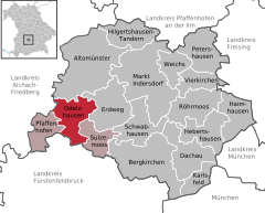
Coordinates 48°19′N 11°11′E / 48.31667°N 11.18333°ECoordinates: 48°19′N 11°11′E / 48.31667°N 11.18333°E Administration Country Germany State Bavaria Admin. region Upper Bavaria District Dachau Municipal assoc. Odelzhausen Local subdivisions 14 Ortsteile Mayor Konrad Brandmaier (Ind.) Basic statistics Area 30.48 km2 (11.77 sq mi) Elevation 499 m (1637 ft) Population 4,312 (31 December 2010)[1] - Density 141 /km2 (366 /sq mi) Other information Time zone CET/CEST (UTC+1/+2) Licence plate DAH Postal code 85235 Area code 08134 Website www.odelzhausen.de  St. Benedikt at Odelzhausen
Odelzhausen is a town and municipality in the west of the region of "Dachau" (Upper Bavaria). The administrative collectivity of Odelzhausen consists of Odelzhausen and the townships of Sulzemoos and Pfaffenhofen an der Glonn.
Contents
Geography
Area members
The municipality of Odelzhausen comprises 14 official local areas.
- Dietenhausen
- Ebertshausen
- Essenbach
- Gaggers
- Hadersried
- Höfa
- Lukka und Todtenried
- Miegersbach
- Roßbach
- Odelzhausen
- St. Johann
- Sittenbach
- Sixtnitgern
- Taxa
The following boundaries exist: Ebertshausen, Höfa, Odelzhausen, Sittenbach, Taxa.
History
- The first name of the village was "Otolteshusir" in 814.
- The name came from Otolt or Odholt - the oldest clan in the area, which live there around 600 or earlier.
- The village was built next to the brook, as there were sufficient pasture fields for a farming community.
- Odelzhausen has a castle, that was already built by 1247. The owners changed often, there were noble and civilian owners, and owners that were only interested in the attached brewery. Today the castle still has a functioning brewery, and also functions as a hotel and restaurant.
- In the middle of the 14th century the old and decrepit roman road was replaced with country roads from Munich through Dachau and Odelzhausen, heading to Freising and Augsburg.
- For the first time in 1440 the village earner the designation "Hofmark" - signaling a right of self rule for the village and its district.
- During the 30 Year War the village incurred a heavy toll. The church was burnt down, the castle was plundered.
- Since around 1700 there has been a school in Odelzhausen, used by the people in neighboring areas.
- Since 1803 Odelzhausen has possessed "Das Marktrecht", or the ability to host markets.
Population growth
The population count for the area was 2323 in 1970, 3,211 in 1987 and 3,998 in 2000.
References
- ^ "Fortschreibung des Bevölkerungsstandes" (in German). Bayerisches Landesamt für Statistik und Datenverarbeitung. 31 December 2010. https://www.statistikdaten.bayern.de/genesis/online?language=de&sequenz=tabelleErgebnis&selectionname=12411-009r&sachmerkmal=QUASTI&sachschluessel=SQUART04&startjahr=2010&endjahr=2010.
-
Altomünster | Bergkirchen | Dachau | Erdweg | Haimhausen | Hebertshausen | Hilgertshausen-Tandern | Karlsfeld | Markt Indersdorf | Odelzhausen | Petershausen | Pfaffenhofen an der Glonn | Röhrmoos | Schwabhausen | Sulzemoos | Vierkirchen | Weichs

Categories:- Municipalities in Bavaria
- Dachau district


Wikimedia Foundation. 2010.