- Dischingen
-
Dischingen 

 DischingenLocation of Dischingen within Heidenheim district
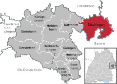

Coordinates 48°41′52″N 10°21′38″E / 48.69778°N 10.36056°ECoordinates: 48°41′52″N 10°21′38″E / 48.69778°N 10.36056°E Administration Country Germany State Baden-Württemberg Admin. region Stuttgart District Heidenheim Local subdivisions 7 Mayor Alfons Jakl (CDU) Basic statistics Area 78.06 km2 (30.14 sq mi) Elevation 463 m (1519 ft) Population 4,419 (31 December 2010)[1] - Density 57 /km2 (147 /sq mi) Other information Time zone CET/CEST (UTC+1/+2) Licence plate HDH Postal code 89561 Area codes 07327, 07326 Website www.dischingen.de Dischingen is a municipality in the district of Heidenheim in Baden-Württemberg in southern Germany. The municipality consists of several smaller villages that have been absorbed into Dischingen including; Dischingen, Ballmertshofen, Demmingen, Dunstelkingen, Eglingen, Frickingen, Trugenhofen and includes Castle Katzenstein[2].
Contents
Demographics
Dischingen has 4,484 inhabitants (as of January 18, 2007), of which 1,811 live in Dischingen with the rest in the surrounding communities. The total land area in the community is 78.06 km2 (30.14 sq mi), of which 6.68 km2 (2.58 sq mi) is buildings, 28.3 km2 (10.9 sq mi) is forest, 42.6 km2 (16.4 sq mi) is farm land and 0.48 km2 (0.19 sq mi) is water[2].
History
Dischingen is first mentioned in 1049. During the Middle Ages it belonged to the county of Dillingen. When the counts of Dillingen died out in 1258, the county was inherited by the House of Wittelsbach. Following the Landshut War of Succession, in 1505 Dischingen became part of the duchy of Palatinate-Neuburg (German: Pfalz-Neuburg). In 1734 the town became the property of the Princely House of Thurn and Taxis. During the German Mediatisation Dischingen became part of Bavaria, though a few years later, in 1810, it became part of Württemberg.
Religion
Dischingen was generally untouched by the Reformation and remained solidly Roman Catholic. The members of the Evangelical Church in Germany in Dischingen belong to the parish of Fleinheim-Dischingen.
Expansion
On 1 January 1972, the village of Trugenhofen joined Dischingen. Two years later, on 1 January 1974, the villages of Ballmertshofen, Demmingen, Dunstelkingen, Eglingen, Frickingen became part of Dischingen.
Politics
Mayor
- 1986–2006 Bernd Hitzler
- Since 2006: Alfons Jakl
Town Council
There are currently 18 seats on the town council. In the town election of 13 June 2004 members of the following two political parties ran with these results:
Party Percent of Votes Change from previous Seats Change CDU 55.0 % −0.4 10 −1 FWG 45.0 % +0.4 8 ±0 Coat of arms
The coat of arms is a divided shield, on the left a red background with an upright golden (yellow) key and on the right a gold (yellow) background with three horizontal knives. The three knives come from the coat of arms of Melchior von Tischingen, dating from 1465. The meaning of the key is unknown.
Coat of arms of the villages
-

Ballmertshofen
-

Demmingen
-

Dunstelkingen
-

Eglingen
-

Frickingen
-

Trugenhofen
See also
References
- ^ "Bevölkerung und Erwerbstätigkeit" (in German). Statistisches Landesamt Baden-Württemberg. 31 December 2009. http://www.statistik-bw.de/Veroeffentl/Statistische_Berichte/3126_10001.pdf.
- ^ a b (German) City of Dischingen Website
Dischingen | Gerstetten | Giengen | Heidenheim an der Brenz | Herbrechtingen | Hermaringen | Königsbronn | Nattheim | Niederstotzingen | Sontheim | Steinheim am Albuch Categories:
- Geography articles needing translation from German Wikipedia
- Municipalities in Baden-Württemberg
- Heidenheim district
- Stuttgart region geography stubs


Wikimedia Foundation. 2010.