- Ocracoke Light
-
Ocracoke Light 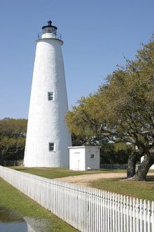
Ocracoke Light Location Ocracoke Island, Hyde County, North Carolina Year first constructed 1798 Year first lit 1823 (current tower) Automated 1955 Foundation Dressed stone / timber Construction Brick with mortar surface Tower shape Conical Markings / pattern White Height 76 feet (23 m) Focal height 75 feet (23 m) Current lens 4th order Fresnel lens
installed 1854Range 15 nm Characteristic Fixed white Fog signal none Admiralty number J2408 ARLHS number USA-561 USCG number 2-660 Ocracoke Light Station

Location: SR 1326, Ocracoke, North Carolina Coordinates: 35°6′32.280″N 75°59′9.671″W / 35.1089667°N 75.98601972°WCoordinates: 35°6′32.280″N 75°59′9.671″W / 35.1089667°N 75.98601972°W Area: 2 acres (0.81 ha) Built: 1823 Architect: Noah Porter Governing body: COAST GUARD NRHP Reference#: 77000110
[3]Added to NRHP: November 25, 1977 Ocracoke Light was built in Hyde County, on Ocracoke Island, North Carolina in 1823 by Massachusetts builder Noah Porter. The lighthouse stands 75 feet (23 m) tall. Its diameter narrows from 25 feet (8 m) at the base to 12 feet (3.7 m) at its peak.
In 1864, Confederate troops dismantled the fourth-order Fresnel Lens, but Union forces later restored it.
Ocracoke Light is the oldest operating light station in North Carolina. The lighthouse was automated in 1955. During the summer months when there is a U.S. National Park Ranger on duty, visitors may access the base of the lighthouse. Access to the top of the lighthouse is not allowed.
The lighthouse was added to the National Register of Historic Places in 1977 as Ocracoke Light Station.
Priority
Various claims have been made about the light, including "the Ocracoke Light is the second oldest operating lighthouse in the nation," from the National Park Service.[4] The original 1795 construction a mile away[2] would qualify only as fifth oldest and the current 1823 tower is about twelfth oldest.
References
- ^ (PDF) Light List, Volume II, Atlantic Coast, Shrewsbury River, New Jersey to Little River, South Carolina. Light List. United States Coast Guard. 2009. p. 6. http://www.navcen.uscg.gov/pdf/lightLists/LightList%20V2.pdf.
- ^ a b "Historic Light Station Information and Photography: North Carolina". United States Coast Guard Historian's Office. http://www.uscg.mil/history/weblighthouses/LHNC.asp.
- ^ "National Register Information System". National Register of Historic Places. National Park Service. 2009-03-13. http://nrhp.focus.nps.gov/natreg/docs/All_Data.html.
- ^ "The Ocracoke Lighthouse". National Park Service. http://www.nps.gov/caha/ocracoke-island-lighthouse.htm. Retrieved 8 February 2010.
 Ocracoke Lighthouse and Silver Lake from Ocracoke National Park Museum
 U.S. Coast Guard Archive
Lighthouses of North Carolina Active: Bodie Island Light • Cape Hatteras Light • Cape Lookout Light • Currituck Beach Light • Oak Island Light • Ocracoke Light
Deactivated/Dismantled: Bald Head Light • Cape Fear Light • Diamond Shoal Light • Federal Point Light • Frying Pan Shoals Light • Hatteras Beacon • Price Creek Light • Roanoke Marshes Light • Roanoke River Light • Wade Point Light
The Outer Banks of North Carolina Landforms Places Currituck County · Dare County · Hyde County · Carteret County
Carova Beach · Corolla · Duck · Southern Shores · Kitty Hawk · Kill Devil Hills · Nags Head · Manteo · Wanchese · Rodanthe · Waves · Salvo · Avon · Buxton · Frisco · Hatteras · Ocracoke · PortsmouthWaterways Lighthouses Currituck Beach Light · Bodie Island Light · Cape Hatteras Light · Ocracoke Light · Cape Lookout LightProtected areas Transportation History U.S. National Register of Historic Places Topics Lists by states Alabama • Alaska • Arizona • Arkansas • California • Colorado • Connecticut • Delaware • Florida • Georgia • Hawaii • Idaho • Illinois • Indiana • Iowa • Kansas • Kentucky • Louisiana • Maine • Maryland • Massachusetts • Michigan • Minnesota • Mississippi • Missouri • Montana • Nebraska • Nevada • New Hampshire • New Jersey • New Mexico • New York • North Carolina • North Dakota • Ohio • Oklahoma • Oregon • Pennsylvania • Rhode Island • South Carolina • South Dakota • Tennessee • Texas • Utah • Vermont • Virginia • Washington • West Virginia • Wisconsin • WyomingLists by territories Lists by associated states Other Categories:- Buildings and structures completed in 1823
- Buildings and structures in Hyde County, North Carolina
- Lighthouses on the National Register of Historic Places
- Lighthouses in North Carolina
- National Register of Historic Places in North Carolina
- Outer Banks
- Visitor attractions in Hyde County, North Carolina
- North Carolina building and structure stubs
- United States lighthouse stubs
- North Carolina Registered Historic Place stubs


Wikimedia Foundation. 2010.