- Nendo Island
-
 NASA picture of Nendo, the largest of the Santa Cruz Islands
Nendo (or more exactly Nendö) is the largest and most important of the Santa Cruz Islands, located in the Temotu province of the Solomon Islands. The island is also known as Santa Cruz, Ndeni, Nitendi or Ndende. The name Santa Cruz was given to the island in 1595 by the Spanish navigator Álvaro de Mendaña de Neira, who unsuccessfully started a colony there.
Contents
Geography
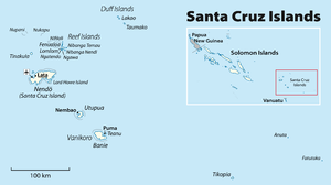
Located at (10°25'12" S. lat., 165°30' E. long.), Nendo is 40 km (25 mi.) long and 22 km (14 mi.) wide. Its land area is 505.5 km² (195 sq. mi.). The highest point on the island is 549 m (1,801 ft.) above sea level.
The two small islands of Malo and Nibanga (also called Tömotu Neo and Tömotu Noi), lie about 1 km (0.6 mi.) distant: Malo to the northwest, Nibanga to the southeast.
Lata, located in the northwestern part of the island, is its chief town and the provincial capital.
Population and languages
Nendo's population is somewhat over 5000. Most indigenous Nendo people are speakers of Natügu, but there are also about 200 speakers of the related Nanggu language (both members of the Reef Islands – Santa Cruz family). Speakers of other Temotu province languages are also present, for example the other Reef Islands – Santa Cruz language Äiwoo, and the Polynesian outlier language Pileni.
References
External links
- A Nendo folktale collected and translated by Robert Viking O'Brien from Marvels & Tales: Journal of Fairy-Tale Studies
- Google Maps
Coordinates: 10°42′36″S 165°49′48″E / 10.710°S 165.830°E
Central Choiseul Guadalcanal Isabel Makira-Ulawa Malaita Adagege · Alite · Anuta Paina · Funaafou · Langa Langa Lagoon · Lau Lagoon · Laulasi · Maana'omba · Malaita · Maramasike · Mbasakana · Ndai · Ontong Java · Roncador Reef · Sikaiana · SulufouRennell and Bellona Temotu Anuta · Banie · Duff Islands · Fatutaka · Fenualoa · Lomlom · Makalom · Malo · Matema · Nendö · Nifiloli · Nukapu · Nupani · Patteson Shoal · Pigeon · Pileni · Reef Islands · Santa Cruz Islands · Taumako · Teanu · Tikopia · Tinakula · Utupua · VanikoroWestern Arundel · Faisi · Fauro · Ghizo · Ghoi · Kavachi · Kennedy · Kiambe · Kingguru · Kohinggo · Kolombangara · Liapari · Logha · Lola · Lumbari · Marovo · Matikuri · Mbava · Mborokua · Mbulo · Mondomondo · Mono · Nakaza · New Georgia · New Georgia Islands · Nggatokae · Nusatupe · Ranongga · Rendova · Shortland · Shortland Islands · Simbo · Stirling · Telina · Tetepare · Treasury Islands · Vella Lavella · Uepi · Vangunu · VonavonaCategories:- Islands of the Solomon Islands
- Solomon Islands geography stubs


Wikimedia Foundation. 2010.