- Great Cumbrae
-
Great Cumbrae Location 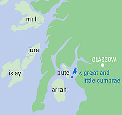
OS grid reference NS169566 Names Gaelic name Cumaradh Mòr Norse name Kumrey Meaning of name Large island of the Cymric people[1] Area and summit Area 1,168 hectares (4.5 sq mi) Area rank 45 Highest elevation The Glaidstane 127 metres (417 ft) Population Population 1434 Population rank 10 out of 97 Main settlement Millport Groupings Island group Firth of Clyde Local Authority North Ayrshire 

References [2][3][4] If shown, area and population ranks are for all Scottish islands and all inhabited Scottish islands respectively. Population data is from 2001 census. Great Cumbrae (Scottish Gaelic, Cumaradh Mòr; also known as Cumbrae or the Isle of Cumbrae) is the larger of the two islands known as The Cumbraes in the lower Firth of Clyde in western Scotland. Home to the National Watersports Centre, the Cathedral of the Isles and the University Marine Biological Station, Millport, the holiday island has an 18-hole golf course which sweeps almost to the summit, and a round-island road much favoured for family cycle runs.
Contents
Geography
 OS Triangulation Pillar at the island's highest point
The island is 3.9 kilometres (2.4 mi) long by 2 kilometres (1.2 mi) wide, rising to a height of 127 metres (417 ft) above sea level at "The Glaidstone" - a large, naturally occurring rock perched on the highest summit on the island. There is a triangulation pillar nearby, as well as an orientation point which indicates the locations of surrounding landmarks.
In clear conditions, views extend north over the upper Clyde estuary to Ben Lomond and the Arrochar Alps. To the west, the larger islands of Bute and Arran can be seen, while on the other side of Knapdale the Paps of Jura may be visible. Looking south, Ailsa Craig is visible, around 40 miles (64 km) distant beyond Little Cumbrae. Ailsa Craig roughly marks the halfway point to Northern Ireland, which itself may be glimpsed if visibility is good. To the east, the views are not so extensive, being restricted by the higher ground of the Renfrew Hills only a few miles distant, however the town of Largs and village of Fairlie and the deep water coal terminal and power station at Hunterston can be seen.
Millport, the island's only town, is spread around a bay which makes up the entire south coast of the island. The usual island population of 1,434 (2001 census) increases substantially during the summer tourist season due to the high proportion of second homes.
The land on the island is primarily owned by the farmers, with the other major land owner being the Millport Golf Club.
Flights across the Atlantic from British and many European airports often pass over the island and can give an excellent view of the surrounding area.
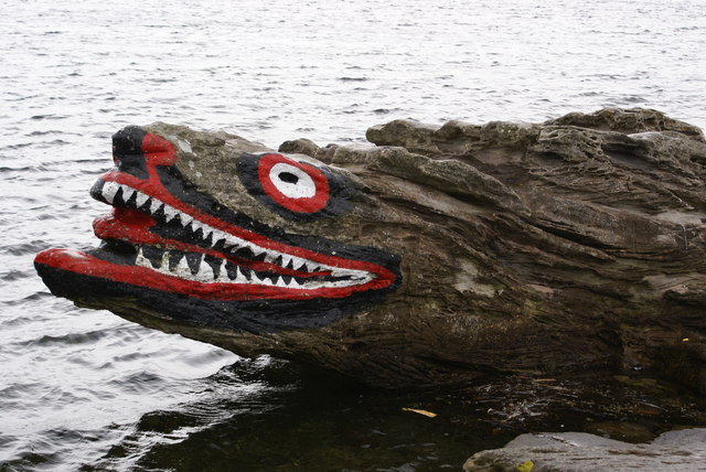
 Crocodile Rock, Millport
Etymology
The Gaelic name Cumaradh means "place of the Cymric people", referring to the Brythonic-speaking inhabitants of the Kingdom of Strathclyde.[1] The Cumbraes are referred to as the Kumreyiar in the Norse Saga of Haakon Haakonarson.[5] The island was previously known in English as Great or Greater Cumray.[3]
Geology
The island is on the Great Cumbrae fault line that runs north east to south west. Fault lines have formed some interesting rock formations which have become popular with tourists, including Crocodile Rock, Indian's Face, Lion's Rock and Queen Victoria's Face. Several have been enhanced with colourful paint.
Cumbrae's western coastline has fine examples of raised beaches. These occurs perhaps most notably in the area surrounding Bell Bay - where the island's highest waterfall, Horse Falls, plunges over the old sea cliffs.
History
The island has been inhabited since the end of the last ice age.
Legend has it that St Mirren, on his return to Scotland from Ireland around AD 710, arrived in Cumbrae and, following the example of St Patrick, rid the island of snakes. The Cathedral of the Isles is reputed to have been built on the site where St Mirren preached. Cumbrae to this day remains snake-free. St Mirren then went on to found a community in Paisley.
It is claimed that Haakon IV, King of Norway used the island as a base before the Battle of Largs (1263).[6]
Cumbrae has long been linked to Christianity in Scotland. At one time the island had many standing stones. The Aberdeen Breviary of 1509, printed in Edinburgh, tells of two of the island's early female missionaries, Saints Beya and Maura.
For many centuries the island was under shared ownership, with the Marquess of Bute in the west and the Earl of Glasgow in the east. In 1999 the final feudal landowner, Le Mans winner Johnny Dumfries, now Bute, of Mount Stuart House, put the island up for general sale, with first refusal given to his farmer tenants.
Tourism grew in the 20th century, and Millport became a popular stop for Clyde steamers and families going 'Doon the Watter for the Fair' (Glasgow Fair holidays). Today most visitors are daytrippers, mostly due to the growth of foreign package holidays in the 1960s. It is still possible to experience a traditional day out on the PS Waverley which operates from both Glasgow and Ayr during the summer.
Tourism

During the summer, the population grows by several thousand every weekend. Hiring a bike and cycling around the island's 11 miles (18 km) encircling coastal road is a popular activity for visitors, as the roads are quiet compared to the mainland. There are informal walks all over the island. Fintry Bay, around 3 miles (5 km) from Millport on the west coast, has a small cafe.
Millport Bay, with visitor moorings, is a popular destination for sailors in the summer. The National Watersports Centre[7] at the ferry slip provides tuition in most boating disciplines, such as powerboating and kayaking, all year round. The most dived site on the Clyde is just south of the ferry slip – a Second World War Catalina flying boat.
A curling pond near the top of the island has not been playable for several years.
Other attractions include:
- Cathedral of the Isles – William Butterfield, one of the great architects of the Gothic revival designed the cathedral church of the Diocese of Argyll and the Isles, within the Episcopal Church of Scotland (Anglican Communion). George Frederick Boyle, 6th Earl of Glasgow acted as the founder and benefactor. Construction finished in 1849 and the cathedral opened in 1851. Formal gardens and woodland surround the cathedral, the highest building on Great Cumbrae and one of the smallest cathedrals in Europe.[8]
- College of the Holy Spirit – attached to the Cathedral, this former seminary for ordination training is now a Retreat House and the Argyll Diocesan Conference Centre. It was the base for The Community of Celebration, or Fisherfolk, an international group of artists and musicians sharing a Benedictine lifestyle during the 1970s and the 1980s.
- The Wedge – a private residence which has the smallest frontage in the UK – the width of a front door.
- Museum of the Cumbraes occupies part of the Garrison, built originally for the captain of an anti-smuggling revenue cutter.
- Marine Biology Station, Keppel Pier – has an aquarium of sea creatures from the Firth of Clyde, and a museum which tells the story of the sea and of the Clyde area. It has a hostel which provides accommodation for visiting parties of marine biology students from around the UK - primarily over the summer months.
Marine environment and wildlife
Cumbrae has a marine climate and can experience gale force winds from the Atlantic at any time of year; these westerly or south-westerly gales can be severe and destructive. However, while the west of the island might be in the throes of a 70 mph gale, the sheltered east side facing Largs can seem like a duckpond.
Local wildlife includes owls, polecats, rabbits, Common Kestrels and the occasional Golden Eagle and Sea Eagle, as well as a large seabird population: fulmars, cormorants, oystercatchers and many more.[9] Other marine life includes seals, basking sharks, porbeagle sharks and dolphins.
The well respected University Marine Biological Station, Millport (UMBSM) is run by the Universities of Glasgow and London. Founded in 1885 by Sir John Murray and David Robertson, it is just outside the town and has an interesting curriculum and research programme which attracts UK and foreign students throughout the academic year. A Museum and Aquarium is open to visitors. In May 2003, in the presence of Princess Anne, the station took delivery of the Macduff-built, 22-metre marine Research Vessel Aora. UMBSM also functions as a Met Office Weather Station and Admiralty Tide Monitor.[10]
Transport
 Car ferries run from Largs pier to Cumbrae Slip: MV Loch Riddon is seen in the foreground, as MV Loch Shira nears Cumbrae.
A Caledonian MacBrayne car ferry connects the island with Largs, Ayrshire on the Scottish mainland. Millport pier dates from 1833[11] and that at Largs from 1845.[12] Renovations to Largs pier in 2008, costing £6m,[12] required the ferry to berth overnight at Fairlie.[citation needed]
Millport was served by Clyde steamers until the 1960s. Largs is now a regular calling point for PS Waverley.[12] For nearly 20 years from 1967, passenger ferry, MV Keppel crossed to Millport pier. In early April 1977, car ferry MV Isle of Cumbrae took up the crossing to Cumbrae Slip and continued until the sisters MV Loch Striven and MV Loch Linnhe arrived in the summer of 1986.[13] A new ferry, MV Loch Shira,[14] built at Ferguson Shipbuilders in Port Glasgow, entered service on 2 June 2007. At peak times, she is partnered by one of the original Loch class vessels.
Environmental issues
Cumbrae lies close to two nuclear power stations - Hunterston A (being de-commissioned) and Hunterston B near Fairlie (Magnox and Advanced gas-cooled reactor respectively). The oil-fired Inverkip Power Station (mothballed) lies to the north near Wemyss Bay, dominating the skyline.
A wind farm lies behind Hunterston B on Busbie Muir, above West Kilbride. It contains twelve 100-metre high turbines, which can be seen from Cumbrae, especially in early morning and late evening light.
The waters nearby are also host to the UK's nuclear deterrent, Vanguard class submarines carrying Trident missiles, from HM Naval Base at Faslane/Coulport, further up the Clyde. The United States Navy, now departed, spent nearly 40 years at the Holy Loch, using the older Polaris Nuclear submarines.
See British replacement of the Trident system for current debate on this issue.
Current Developments
It is currently being proposed (March 2007) to initiate an environmentally friendly facility at Wine Bay, near the north end of the island. This would at least involve a vegetable garden and composting facilities and it is hoped that this would eventually become self-sufficient and employ local people.[15]
A forestry project is under way on the hillside above Ballochmartin Farm, on either side of the Inner Circle road. Trees are being planted throughout spring 2007.
Notable residents
- Duncan Macrae (actor and comedian, Whisky Galore, The Prisoner)[16]
- Stephens Orr (society photographer)
- David Robertson (naturalist)[17]
- The Saxon (a Clyde puffer which provided a shipping service to the island) and which featured in the TV series The Vital Spark, based on Neil Munro's Para Handy stories about the Vital Spark.
Media and the arts
The island was featured in the BBC Radio 4 comedy series, Millport, written by and starring Lynn Ferguson.
See also
- Little Cumbrae
- Little Cumbrae Castle
Footnotes
- ^ a b Mac an Tàilleir p. 36
- ^ General Register Office for Scotland (28 November 2003) Occasional Paper No 10: Statistics for Inhabited Islands. Retrieved 9 July 2007.
- ^ a b Haswell-Smith (2004) pp. 18-20
- ^ "Get-a-Map" Ordnance Survey Retrieved 14 July 2009.
- ^ "cömbröɣ" "Brittonic Language in the Old North". Scottish Place-Name Society. Retrieved 14 Sept 2011.
- ^ Gazeteer for Scotland. "Great Cumbrae Overview". http://www.scottish-places.info/features/featurefirst1708.html. Retrieved 2007-04-06.
- ^ sportscotland. "National Watersports Centre". http://www.nationalcentrecumbrae.org.uk/. Retrieved 2007-04-06.
- ^ The building is variously described as "the smallest cathedral in Europe", "the second smallest in Europe" etc. See for example "Millport Musings" (19 November 2005) BBC. Retrieved 11 May 2008, "About Cumbrae" Westbourne House. Retrieved 11 May 2008. Various other churches such as the cathedrals in Nin and Zadar in Croatia lay claim to this title.
- ^ "Where to Watch Birds in Ayrshire". http://s115507184.websitehome.co.uk/locations/cumbrae.htm. Retrieved 2007-04-06.
- ^ "About UMBSM". University of Glasgow. http://www.gla.ac.uk/marinestation/about_frame.html. Retrieved 11 September 2010.
- ^ "Millport". Undiscovered Scotland. http://www.undiscoveredscotland.co.uk/cumbrae/millport/index.html. Retrieved 11 September 2010.
- ^ a b c "Largs pier could put Waverley up the creek without a paddle". The Herald (Glasgow). 27 June 2009. http://www.heraldscotland.com/largs-pier-could-put-waverley-up-the-creek-without-a-paddle-1.913438. Retrieved 11 September 2010.
- ^ McCrorie, Ian (2006). CalMac Ferries. Caledonian MacBrayne. ISBN 9780950716671.
- ^ "MV Loch Shira". Calmac. http://www.calmac.co.uk/mv_loch_shira.html. Retrieved 2007-04-06.
- ^ Largs & Millport Weekly (2007-03-15). "Beechgrove Garden for Island". http://www.largsandmillportnews.com/?module=displaystory&story_id=918&format=html. Retrieved 2007-04-05.
- ^ Scottish Daily Record. "Millport.(Town of the Week)". http://www.highbeam.com/doc/1G1-74763742.html. Retrieved 2005-12-10.
- ^ "David Robertson". gashe.ac.uk. http://www.gashe.ac.uk:443/isaar/P0296.html. Retrieved 2007-03-04.
References
- Haswell-Smith, Hamish (2004). The Scottish Islands. Edinburgh: Canongate. ISBN 1841954543.
- Iain Mac an Tàilleir. "Placenames" (pdf). Pàrlamaid na h-Alba. http://www.scottish.parliament.uk/vli/language/gaelic/pdfs/placenamesC-E.pdf. Retrieved 23 July 2010.
Islands of Scotland Northern Isles 
Hebrides Other Categories:


Wikimedia Foundation. 2010.