- Cork Harbour
-
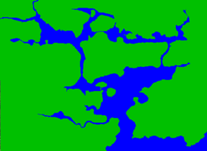 Outline map of Cork Harbour
Cork Harbour is a natural harbour and river estuary at the mouth of the River Lee in County Cork, Ireland. It is one of several which lay claim to the title of "second largest natural harbour in the world by navigational area" (after Port Jackson, Sydney, Australia). Other contenders include Halifax Harbour in Canada, and Poole Harbour in England. The largest non-navigational harbour and the largest natural harbour in the world is New Zealands Kaipara Harbour, at 947km2.
Contents
Population
Cork City is located slightly upstream on the River Lee on the northwest corner of Cork Harbour. Several of the city's suburbs, including Blackrock, Mahon, Douglas, Passage West and Rochestown lie on Lough Mahon or the Douglas Estuary, both of which are parts of Upper Cork Harbour.
The Lower Harbour has many towns around its shores. Passage West, Monkstown, Ringaskiddy and the smaller village of Raffeen are found on the western shore. On the southwestern shore is Crosshaven. Great Island, which forms the northern shore of the lower harbour, houses the town of Cobh. The eastern shore is less densely populated, but has two villages Whitegate and Aghada, both home to power plants..
The village of Ballinacurra is found on the northeastern spur of the harbour, known as the Ballynacorra River. Due to the recent expansion of the town of Midleton, Ballinacurra has effectively become a suburb of Midleton, so it could also be said that Midleton lies on Cork Harbour.
Islands
Cork Harbour contains a large number of islands. The inhabited islands include:
- Great Island - The largest island in Cork Harbour with a population of over 10,000; it includes the town of Cobh. There is also significant agricultural activity on the island.
- Fota Island - Containing Fota Wildlife Park, Fota Golf Course, Fota House and the Sheraton Hotel.
- Little Island - A residential and industrial area
- Haulbowline Island - The headquarters of the Irish Navy
- Spike Island - A former prison island
- Harper Island, County Cork
- Hop Island, County Cork - An Equestrian Centre
- Weir Island, County Cork
- Brick Island, County Cork
- Corkbeg Island, County Cork - Whitegate Oil Refinery
- Brown Island, County Cork
- Rocky Island - Once housed a magazine building for the Royal Navy. Used by Irish Steel for storage until 2002. Now home to The Island Crematorium, the first crematorium in Ireland outside Dublin.
Military
Cork Harbour hosts the headquarters of the Irish Navy. Prior to the transfer of the treaty ports in 1938, Cork Harbour was an important base for the British Royal Navy.
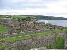
The first fortifications were built in Cork Harbour in the 17th century, although these were primarily to protect Cork City. In the 18th century, fortifications were built on Haulbowline Island to protect the anchorage in Cobh. Fort Camden and Fort Carlisle at opposite sides of the harbour entrance were built during the American War of Independence.
 The fortifications at Charles Fort (17th century) overlooking Kinsale harbour.
However, the harbour's military significance began during the Napoleonic Wars when the naval establishment in Kinsale was transferred to Cork Harbour. The harbour became an important anchorage, which could be used to guard the entrance to the English Channel and maintain the blockade of France. At this time, the naval dockyard on Haulbowline Island was constructed as well as a fort on Spike Island (later to become Fort Westmoreland) and a number of Martello Towers around the harbour.
The fortifications were developed throughout the 19th century[1] and a further fort, Fort Templebreedy, was added to the south of Fort Camden at the beginning of the 20th century..
At the time of Irish independence, Cork Harbour was included, along with Berehaven and Lough Swilly, in a list of British naval establishments that would remain under the control of the Royal Navy, although, the naval dockyard on Haulbowline Island was handed over to the Irish Free State in 1923.
Although, the Royal Navy appreciated the location of Cork Harbour, particularly for submarines, which had a significantly shorter range in the 1920s, maintenance of the fortification became a problem as soon as Ireland had become independent. The political uncertainty over the future of the treaty ports meant that the British government was not inclined to invest in their upgrade. Also, at the time of their construction, nobody had considered the possibility of air attack and as they were unable to expand, there was no possibility of adding adequate air cover. Finally, if the Irish Free State was hostile during any conflict, the treaty ports would have to be supplied by sea rather than land, wasting resources.
In March 1938, the British government announced that the treaty ports would be handed over to Ireland unconditionally. On July 11, 1938, the defences at Cork Harbour were handed over to the Irish military authorities at a ceremony attended by Taoiseach Éamon de Valera.
Since, being handed over to the Irish military most of the military installations have become unused. Fort Carlisle was renamed Fort Davis and is used by the Defence Forces for FIBUA training but is in a neglected state. Fort Camden became Fort Meagher and has gone out of use. Fort Westmoreland became Fort Mitchell Spike Island prison, but is currently out of service. However, the fortifications on Haulbowline Island have been maintained and are now the headquarters of the Irish Navy.
Industry
Cork Harbour is one of the most important industrial areas in Ireland. While many older industries such as shipbuilding at Verolme Dockyards, steel-making on Haulbowline Island and fertiliser manufacturing at NET (Nitrigen Éireann Teoranta) have declined or ceased in recent years, they have been replaced with newer industries and Cork Harbour is now significant at a worldwide level within the pharmaceutical industry. Major international firms such as Pfizer, Novartis, GlaxoSmithKline and Janssen Pharmaceutica (a subsidiary of Johnson & Johnson) are significant employers in the region. There are in excess of 100 other pharmaceutical firms operating in the Cork Harbour area. The principal of the pharmaceutical industry are Little Island and Ringaskiddy
Marine activity
Commercial
Further information: Port of CorkVessels up to 90,000 metric tons deadweight (DWT) are capable of coming through the harbour entrance . As the shipping channels get shallower the farther inland one travels, access becomes constricted, and only vessels up to 60,000 DWT can sail above Cobh.
The Port of Cork provides pilotage and towage facilities for vessels entering Cork Harbour. All vessels accessing the quays in Cork City must be piloted and all vessels exceeding 130 metres in length must be piloted once they pass within 2.5 nautical miles (4.6 km) of the harbour entrance.
The Port of Cork has berthing facilities at Cork City, Tivoli, Cobh and Ringaskiddy. The facilities in Cork City are primarily used for grain and oil transport. Tivoli provides container handling, facilities for oil, livestock and ore and a roll on-roll off (Ro-Ro) ramp. Prior to the opening of Ringaskiddy Ferry Port, car ferries sailed from here; now, the Ro-Ro ramp is used by companies importing cars into Ireland. In addition to the ferry terminal, Ringaskiddy has a deep water port. .
The Port of Cork company is a commercial semi-state company responsible for the commercial running of the harbour as well as responsibility for navigation and berthage in the port. In 2006 the port had a turnover of €26.4 million and made pre-tax profits of €5.4 million. Container traffic has increased considerably in recent years and 185,000 teus were handled at the Tivoli container facility.[2] This is at capacity and the Port drew up plans for a new container facility capable of handling up to 400,000 teus per annum at Ringaskiddy recently. This was the subject of major objections and after an Oral Planning Hearing was held in 2008 the Irish planning board Bord Pleanala rejected the plan due to inadequate rail and road links at the location.[3]
There has been a steady increase in cruise ship visits to Cork Harbour over the past few years with 51 such ships due to visit in 2008.[4] The vast majority of these cruise ships berth at Cobh's deepwater quay.
There are also a number of private berths around the harbour. These are usually associated with a particular industry. Such berths can be found in Whitegate, Passage West, Rushbrooke, Ringaskiddy and Haulbowline.
Recreational
The Royal Cork Yacht Club - the world's oldest - is based in Crosshaven. There is another marina at East Ferry on Great Island. Small facilities at Monkstown and Blackrock are used for boating, canoeing, windsurfing and jet-skiing. A number of rowing clubs have facilities on the part of the River Lee between Cork City and Blackrock.
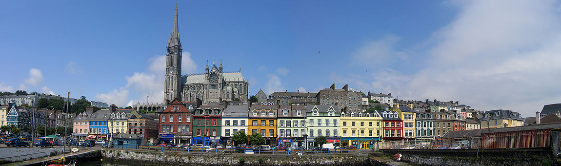 The waterfront at Cobh
References
- ^ Stevenson, I., Fort (Fortress Study Group), 1999 (27), pp113-143
- ^ untitled
- ^ RTÉ News: Port of Cork €225m development rejected
- ^ Cobh Liner Season List 2008
External links
- Port of Cork Company website
- Cork Harbour Weather Conditions and Weather Cam
- Cork Harbour Fortifications
See also
- The Emergency
- Plan W
- Joseph Wheeler for further information on 19th century shipbuilding in Cork.
Categories:- Cork (city)
- Transport in County Cork
- Ports and harbours of the Republic of Ireland
- Visitor attractions in County Cork
- Celtic Wave ports
- Important Bird Areas of the Republic of Ireland


Wikimedia Foundation. 2010.