- Chippendale, New South Wales
-
Chippendale
Sydney, New South Wales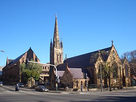
St Benedicts Church and University of Notre DamePopulation: 3,300 (2001 census) • Density: 4714.3/km² (12,210.0/sq mi) Postcode: 2008 Area: 0.7 km² (0.3 sq mi) Location: 2 km (1 mi) south of CBD LGA: City of Sydney State District: Sydney Federal Division: Sydney Suburbs around Chippendale: Glebe Ultimo Haymarket Camperdown Chippendale Surry Hills Darlington Darlington Redfern 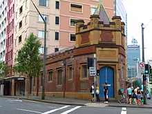 John Storey Memorial Dispensary (1926)
Chippendale is a small inner-city suburb of Sydney, New South Wales, Australia. Chippendale is located on the southern edge of the Sydney central business district, in the local government area of the City of Sydney. Chippendale is sandwiched between Broadway to the north and Cleveland Street to the south, Sydney Central railway station to the east and the University of Sydney to the west.
Contents
History
The area was first occupied by the Gadigal people of the Dharug Nation. William Chippendale was granted a 95-acre (38 ha) estate in 1819. It stretched to the present day site of Redfern railway station. Chippendale sold the estate to Solomon Levey, emancipist and merchant, in 1821, for 380 pounds. Solomon Levey died while in London, in 1833. Levey's heirs sold over 62 acres (25 ha) to William Hutchinson.[1][2]
Commercial area
The eastern side of Chippendale, being adjacent to the CBD, includes a greater mix of uses than other parts of the suburb. It includes commercial uses such as offices and warehouses, with higher buildings facing Regent Street and Broadway. Elsewhere in Chippendale there are scattered shops, cafes and pubs. The small suburb depends on Broadway for shopping and services. The historic Regent Street railway station or 'Mortuary Station' is located on the eastern side of the suburb.
The John Storey Memorial Dispensary was built in 1926 as a memorial to John Storey, a former Premier of New South Wales. It is located in Little Regent Street and still functions as a pathology clinic.
Future development
Chippendale is notable for being the location of the 168-year-old Carlton & United brewery, although this is now closed. Frasers Property Australia purchased the brewery site from the Foster’s Group on 29 June 2007. In July 2008, Frasers Property lodged a modified concept plan with the NSW Department of Planning proposing a mixed-use development for the 5.8 Hectare site. The development proposal includes approximately 250,000m2 of commercial and residential space, retention of a number of heritage buildings and the development of a large new park for Chippendale.[3]
Government and infrastructure
Transport New South Wales has its headquarters in Chippendale.[4]
Schools
The University of Notre Dame Australia sits along the northern border. The University of Technology, Sydney and the University of Sydney have campuses nearby. The Sydney campus of Curtin University is located at the eastern edge of Chippendale on Regent Street. The Boston University Sydney Campus is also located on Regent Street in Chippendale.
Houses
The western side of Chippendale is mainly residential. Chippendale has the lowest open space per person of any Sydney suburb, according to The Sydney Morning Herald.
Gallery
-

Chippen Street flats
-

Meagher Street flats and gallery
-

Shannon Hotel
-

UTS Blackfriars Campus
-

Mortuary Station
References
- ^ The Book of Sydney Suburbs, Compiled by Frances Pollen, Angus & Robertson Publishers, 1990, Published in Australia ISBN 0-207-14495-8
- ^ Libraries Australia. Part of Chippendale's grant. http://nla.gov.au/anbd.bib-an000040747752
- ^ http://www.frasersbroadway.com.au/broadway/
- ^ "Copyright and Disclaimer." Transport New South Wales. Retrieved on 8 December 2010. "Transport NSW 18 Lee Street Chippendale NSW 2008"
Further reading
- Shirley Fitzgerald. CHIPPENDALE - Beneath The Factory Wall. Published by Halstead Press, Australia.2007. (ISBN 9781920831486).
External links
- Chippendale, New South Wales is at coordinates 33°53′11″S 151°12′00″E / 33.88634°S 151.19992°ECoordinates: 33°53′11″S 151°12′00″E / 33.88634°S 151.19992°E
Suburbs and localities within the City of Sydney Suburbs Alexandria · Annandale · Barangaroo · Beaconsfield · Camperdown · Centennial Park · Chippendale · Darlinghurst · Darlington · Dawes Point · Elizabeth Bay · Erskineville · Eveleigh · Forest Lodge · Glebe · Haymarket · Millers Point · Moore Park · Newtown · Paddington · Potts Point · Pyrmont · Redfern · Rosebery · Rushcutters Bay · Surry Hills · Sydney CBD · The Rocks · Ultimo · Waterloo · Woolloomooloo · Zetland
Localities List of Sydney suburbs Categories:- Suburbs of Sydney
- Sydney geography stubs
-


Wikimedia Foundation. 2010.