- Isle of Arran
-
This article is about the Scottish island. For other uses, see Arran.
Isle of Arran Location 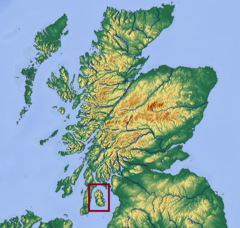
OS grid reference NR950359 Names Gaelic name  Eilean Arainn (help·info)
Norse name Herrey[1] Meaning of name Possibly Brythonic for "high place" Area and summit Area 43,201 hectares (167 sq mi) Area rank 7[2] Highest elevation Goat Fell 874 m (2,867 ft) Population Population 5,058[3] Population rank 6[3] out of 97 Popn. density 11.68 people/km2[3][4] Main settlement Brodick Groupings Island group Firth of Clyde Local Authority North Ayrshire 

References [5] If shown, area and population ranks are for all Scottish islands and all inhabited Scottish islands respectively. Population data is from 2001 census. Arran or the Isle of Arran (Scots Gaelic: Eilean Arainn) is the largest island in the Firth of Clyde, Scotland, and with an area of 432 square kilometres (167 sq mi) is the seventh largest Scottish island. It is in the unitary council area of North Ayrshire and the 2001 census had a resident population of 5,058. Although commonly associated with the Hebrides, with which it shares many cultural and physical similarities, these latter islands are located to the north and west beyond Kintyre. Arran is mountainous and has been described as a "geologist's paradise".[6]
There has been continuous habitation since the early Neolithic period, and there have been numerous prehistoric remains found since then. From the 6th century on Goidelic-speaking peoples from Ireland colonised the island and it became a centre of religious activity. During the troubled Viking Age, Arran became the property of the Norwegian crown before becoming formally absorbed by the kingdom of Scotland in the thirteenth century. The 19th century "clearances" led to significant reductions in population and the end of the Gaelic language and way of life.
The economy and population have recovered in recent years, the main industry being tourism. There is diversity of wildlife, including three species of tree endemic to the area.
Contents
Etymology
Most of the islands of Scotland have been occupied by the speakers of at least four languages since the Iron Age, and many of the names of these islands have more than one possible meaning as a result. Arran is therefore not unusual in that the derivation of the name is far from clear. Mac an Tàilleir (2003) states that "it is said to be unrelated to the name Aran in Ireland" (which means "kidney shaped", cf Irish ára "kidney").[7] Unusually for a Scottish island, Haswell-Smith (2004) offers a Brythonic derivation and a meaning of "high place" which at least corresponds with the geography—Arran is significantly loftier than all the land that immediately surrounds it along the shores of the Firth of Clyde.[6]
Any other Brythonic place names that may have existed were later replaced on Arran as the Goidelic-speaking Gaels spread from Ireland via their adjacent kingdom of Dál Riata. During the Viking Age the island, along with the vast majority of the Scottish islands, became the property of the Norwegian crown, at which time it may have been known as "Herrey" or "Hersey". As a result of this Norse influence, many current place names on Arran are of Viking origin.[8]
Geography and geology
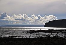 Clouds over Kildonan Bay on the southern tip of Arran
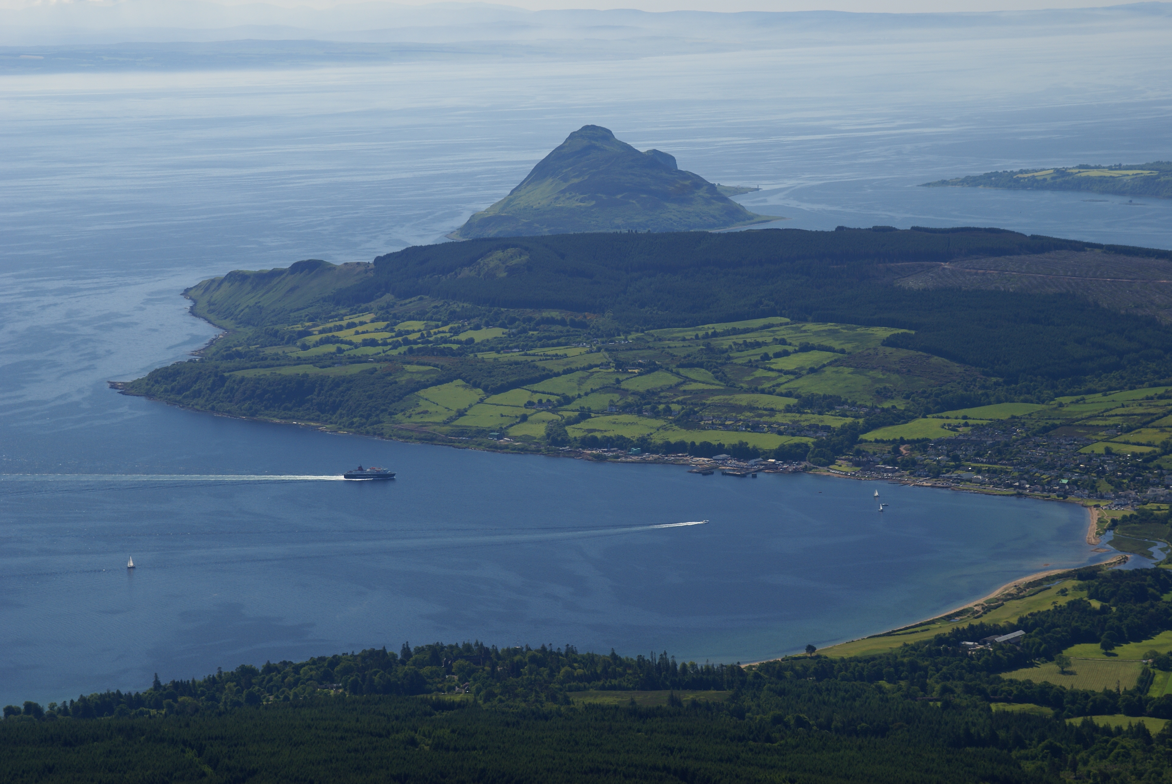
The island lies in the Firth of Clyde between Ayr and Kintyre. The profile of the north Arran hills as seen from the Ayrshire coast is a well-known sight referred to as the "Sleeping Warrior" due to its resemblance to a resting human figure.[9][10] The highest of these hills is Goat Fell at 873.5 metres (2,866 ft).[11] There are three other Corbetts all in the north east; Caisteal Abhail, Cìr Mhòr and Beinn Tarsuinn. Bheinn Bharrain is the highest peak in the north west at 721 metres (2,365 ft).[12]
The largest valley on the island is Glen Iorsa to the west, whilst narrow Glen Sannox (Gaelic: Gleann Shannaig) and Glen Rosa (Gaelic: Gleann Ròsa) to the east surround Goat Fell. The terrain to the south is less mountainous, although a considerable portion of the interior lies above 350 metres (1,150 ft) and the summit of A' Chruach reaches 512 metres (1,680 ft).[13][14] There are two other Marilyns in the south, Tighvein and Beinn Bhreac.
The island is sometimes referred to as "Scotland in miniature", as it is divided into "Highland" and "Lowland" areas by the Highland Boundary Fault which runs northeast to southwest across Scotland.[15] Arran is a popular destination for geologists, who come to see intrusive igneous landforms such as sills and dykes as well as sedimentary and metasedimentary rocks ranging in age from Precambrian to Mesozoic.
Most of the interior of the northern half of the island is taken up by a large granite batholith that was created by substantial volcanic activity around 60 million years ago in the Tertiary period. There is an older outer ring of coarse granites and an inner core of finer grained material. Sedimentary rocks dominate the southern half of the island, especially Old and New Red Sandstone. Some of these sandstones contain fulgurites - pitted marks that may have been created by Permian lightning strikes.[15] Sand dunes are preserved in Permian sandstones near Brodick, there are localised outcrops of Triassic rocks and even a rare example of Cretaceous chalk.[16][17] During the nineteenth century barytes was mined near Sannox. First discovered in 1840, nearly 5,000 tons were produced between 1853 and 1862. The mine was closed by the 11th Duke of Hamilton on the grounds that it "spoiled the solemn grandeur of the scene" but was reopened after the First World War and operated until 1938 when the vein ran out.[18][19]
Visiting in 1787, the geologist James Hutton found his first example of an unconformity to the north of Newton Point near Lochranza, which provided evidence for his Plutonist theories of uniformitarianism and about the age of the Earth. This spot is one of the most famous places in the study of geology.[20][21]
The Pleistocene glaciations almost entirely covered Scotland in ice and Arran's highest peaks may have been nunataks at this time.[15] After the last retreat of the ice at the close of the Pleistocene epoch sea levels were up to 70 metres (230 ft) lower than at present and it is likely that circa 14,000 BP the island was connected to mainland Scotland.[22] Sea level changes and the isostatic rise of land makes charting post-glacial coastlines a complex task, but it is evident that the island is ringed by post glacial raised beaches.[23] King's Cave on the south west coast is an example of an emergent landform on such a raised beach. This cave, which is over 30.5 metres (100 ft) long and up to 15.3 metres (50 ft) high, lies well above the present day sea level.[24][25][26] There are tall sea cliffs to the north east including large rock slides under the heights of Torr Reamhar and at Scriden (An Scriodan) at the far north end of the island.[14][27] North Arran is one of 40 National Scenic Areas in Scotland.[28]
Villages
See also: Category:Villages in the Isle of Arran Holy Isle as seen from Arran
Arran has a number of villages that are mainly found around the shoreline. Brodick (Old Norse: "broad bay") is the site of the ferry terminal, several hotels, and the majority of shops. Brodick Castle is a seat of the Dukes of Hamilton. Lamlash, however, is the largest village on the island and in 2001 had a population of 1,010 compared to 621 for Brodick.[29] Other villages include Lochranza and Catacol in the north, Corrie in the north east, Blackwaterfoot in the south west, Kildonan in the south and Whiting Bay in the south east.
Surrounding islands
Main article: Islands of the ClydeArran has three smaller satellite islands: Holy Isle lies to the east opposite Lamlash, Pladda is located off Arran's south coast and tiny Hamilton Isle lies just off Clauchlands Point 1.2 kilometres (0.75 mi) north of Holy Isle. Eilean na h-Àirde Bàine off the south west of Arran at Corriecravie is a skerry connected to Arran at low tide.
Other islands in the Firth of Clyde include Bute, Great Cumbrae and Inchmarnock.
Climate
The influence of the Atlantic Ocean and the Gulf Stream create a mild oceanic climate. Temperatures are generally cool, averaging about 6 °C (43 °F) in January and 14 °C (57 °F) in July at sea level.[30] The southern half of the island, being less mountainous has a more favourable climate than the northern half and the east coast is more sheltered from the prevailing winds than the west and south.
Snow seldom lies at sea level and frosts are less frequent than the mainland. In common with most islands of the west coast of Scotland, rainfall is generally high at between 1,500 mm (59 in) per annum in the south and west and 1,900 mm (75 in) per annum in the north and east. The mountains are wetter still with the summits receiving over 2,550 mm (100 in) annually. May and June are the sunniest months, with upwards of 200 hours of bright sunshine being recorded on average.[30]
History
Prehistory
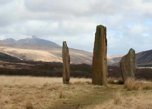
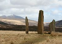 Machrie Moor Standing Stones
Arran has a particular concentration of early Neolithic Clyde Cairns, a form of Gallery grave. The typical style of these structures is that of a rectangular or trapezoidal stone and earth mound that encloses a chamber lined with larger stone slabs. Pottery and bone fragments found inside the chambers suggest they were used for internment and some have forecourts, which may have been an area for public display or ritual. There are two good examples in Monamore Glen east of the village of Lamlash,[31] and similar structures called the Giant's Graves above Whiting Bay. There are numerous standing stones dating from prehistoric times, including six stone circles on Machrie Moor (Gaelic: Am Machaire).[32]
Several Bronze Age sites have been excavated, including "Ossian's Mound" near Clachaig and a cairn near Blackwaterfoot that produced a bronze dagger and a gold fillet.[33] Torr a' Chaisteal Dun in the south west near Sliddery is the ruin of an Iron Age fortified structure dating from about AD 200. The original walls would have been 3 metres (9.8 ft) or more thick and enclosed a circular area about 14 metres (46 ft) in diameter.[34]
Gaels, Vikings and the medieval era
An ancient Irish poem called Agalllamh na Senorach, first recorded in the 13th century, describes the attractions of the island.
- Arran of the many stags
- The sea strikes against her shoulders,
- Companies of men can feed there,
- Blue spears are reddended among her boulders.
- Merry hinds are on her hills,
- Juicy berries are there for food,
- Refreshing water in her streams,
- Nuts in plenty in the wood.[35]
The monastery of Aileach founded by St. Brendan in the 6th century may have been on Arran and St. Molaise was also active, with Holy Isle being a centre of his activities.[36] The caves below Keil Point (Gaelic: Rubha na Cille) contain a slab which may have been an ancient altar. This stone has two petrosomatoglyphs on it, the prints of two right feet, said to be of Saint Columba.[37]
In the 11th century Arran became part of the Sodor (Old Norse: 'Suðr-eyjar'), or South Isles of the Kingdom of Mann and the Isles, but on the death of Godred Crovan in 1095 all the isles came under the direct rule of Magnus III of Norway. Lagman (1103–1104) restored local rule. After the death of Somerled, Arran and Bute were ruled by his son Angus.[38] In 1237, the Scottish isles broke away completely from the Isle of Man and became an independent kingdom, before being ceded to the Scottish crown in 1266 by the Treaty of Perth. A substantial Viking grave has been discovered near King's Cross south of Lamlash, containing whalebone, iron rivets and nails, fragments of bronze and a 9th century bronze coin, and another grave of similar date nearby yielded a sword and shield.[39] Arran was also part of the medieval Bishopric of Sodor and Man.
On the opposite side of the island near Blackwaterfoot is the King's Cave (see above) where Robert the Bruce is said to have taken shelter in the 14th century.[40] Bruce returned to the island in 1326, having earlier granted lands to Fergus MacLouis for assistance rendered during his time of concealment there. Brodick Castle played a prominent part in the island's medieval history. Probably dating from the 13th century, it was captured by English forces during the Wars of Independence before being taken back by Scottish troops in 1307. It was badly damaged by action from English ships in 1406 and sustained an attack by John of Islay, the Lord of the Isles in 1455. Originally a seat of the Clan Stewart of Menteith it passed to the Boyd family in the 15th century.[41][42] For a short time during the reign of King James V in the 16th century the Isle of Arran was under the regency of Robert Maxwell, 5th Lord Maxwell.[43]
Modern era
At the commencement of the Early modern period James, 2nd Lord Hamilton became a privy counsellor to his first cousin, James IV of Scotland and helped to arrange his marriage to Princess Margaret Tudor of England. As a reward he was created Earl of Arran in 1503. The local economy for much of this period was based on the run rig system, the basic crops being oats, barley and potatoes and the population slowly grew to about 6,500. In the early 19th century Alexander, 10th Duke of Hamilton (1767–1852) embarked on a programme of clearances that had a devastating effect on the island's population. These "improvements" typically led to the land being rented out to as many as twenty-seven families being converted into a single farm. In some cases, alternative land was promised in Canada for each adult emigrant male. In April 1829, for example, 86 islanders boarded the brig Caledonia for the two-month journey, half their fares being paid for by the Duke. However, on arrival in Quebec only 41 hectares (100 acres) was made available to the heads of extended families. Whole villages were removed and the Gaelic culture of the island devastated. The writer James Hogg wrote: "Ah! Wae's me. I hear the Duke of Hamilton's crofters are a' gaun away, man and mother's son, frae the Isle o' Arran. Pity on us!".[44] A memorial to this early form of ethnic cleansing has been constructed on the shore at Lamlash, paid for by a Canadian descendant of the emigrants.[45][46]
On 10 August 1941 a RAF Consolidated B-24 Liberator LB-30A AM261 was flying from RAF Heathfield in Ayrshire to Gander International Airport in Canada. However, the B-24 crashed into the hillside of Mullach Buidhe north of Goat Fell where all 22 passengers and crew died.[47]
Overview of population trends Year Population[48] Year Population 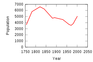
1755 3,646 1931 4,506 1782 5,804 1961 3,700 1821 6,600 1971 3,564 1841 6,241 1981 3,845 1881 4,730 1991 4,474 1891 4,824 2001 5,058 Gaelic
Pronunciation Scots Gaelic: A’ Chruach Pronunciation: [ə ˈxɾuəx] (  listen)
Scots Gaelic: Am Machaire Pronunciation: [ə ˈmaxəɾʲə] ( listen)Scots Gaelic: Arainn nan Aighean Iomadh Pronunciation: [ˈaɾəɲ ə ˈn̪ˠajən ˈiməɣ] ( listen)Scots Gaelic: Arannach Pronunciation: [ˈaɾən̪ˠəx] ( listen)Scots Gaelic: Beinn Bharrain Pronunciation: [peiɲˈvarˠɛɲ] ( listen)Scots Gaelic: Beinn Bhreac Pronunciation: [peiɲˈvɾʲɛxk] ( listen)Scots Gaelic: coinean mòr Pronunciation: [ˈkʰɔɲan ˈmoːɾ] ( listen)Scots Gaelic: Eilean Arainn Pronunciation: [elanˈarəɲ] ( listen)Scots Gaelic: Eilean na h-Àirde Bàine Pronunciation: [ˈelan ə ˈhaːrˠtʲə ˈpaːɲə] ( listen)Scots Gaelic: Gleann Ròsa Pronunciation: [klɛun̪ˠˈrˠɔːs̪ə] ( listen)Scots Gaelic: Gleann Sgoradail Pronunciation: [klaun̪ˠ ˈs̪kɔɾat̪al] ( listen)Scots Gaelic: Gleann Shannaig Pronunciation: [klɛun̪ˠˈhan̪ˠɛkʲ] ( listen)Scots Gaelic: Rubha na Cille Pronunciation: [ˈrˠu.ə nə ˈkʲʰiʎə] ( listen)Gaelic was still spoken widely on Arran at the beginning of the 20th century. The 1901 Census reported 25-49% Gaelic speakers on the eastern side of the island and 50-74% on the western side of the island. By 1921 the percentage for the whole island had dropped to less than 25%. From then onwards, the number of speakers fell into the vague 0-24.9% bracket.[49] However, Nils Holmer quotes the Féillire (a Gaelic almanack) reporting 4,532 inhabitants on the island in 1931 with 605 Gaelic speakers, showing that Gaelic had declined to about 13% of the population.[50] It continued to decline until the last native speakers of Arran Gaelic died in the 1990s. The 1.6% Gaelic speakers in the 1991 Census and the 1.5% in the 2001 Census represent Gaelic speakers from other areas settling on the island.[51]
Arran Gaelic is reasonably well documented. Holmer carried out fieldwork on the island in 1938, reporting Gaelic being spoken by "a fair number of old inhabitants". He interviewed 53 informants from various locations and his description of the dialect, The Gaelic of Arran, was published in 1957 and runs to 211 pages of phonological, grammatical and lexical information. The Survey of the Gaelic Dialects of Scotland, which collected Gaelic dialect data in Scotland between 1950 and 1963 also interviewed 5 native speakers of Arran Gaelic.[52]
The Arran dialect falls firmly into the southern group of Gaelic dialects (referred to as the "peripheral" dialects in Celtic studies) and thus shows:[50]
- a glottal stop replacing an Old Irish hiatus, e.g. rathad 'road' /rɛʔət̪/[50] (normally /rˠa.ət̪/)
- the dropping of /h/ between vowels e.g. athair 'father' /aəɾ/[50] (normally /ahəɾʲ/)
- the preservation of a long l, n and r, e.g. fann 'weak' /fan̪ˠː/[50] (normally /faun̪ˠ/ with diphthongisation).
The most unusual feature of Arran Gaelic is the /w/ glide after labials before a front vowel, e.g. maith 'good' /mwɛh/[50] (normally /mah/).
Mac an Tàilleir (2003) notes that the island has a poetic name Arainn nan Aighean Iomadh - "Arran of the many stags" and that a native of the island or Arannach is also nicknamed coinean mòr in Gaelic, meaning "big rabbit".[7] Locally, Arainn was pronounced /ɛɾɪɲ/.[50]
Local government
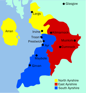
 Arran's location within Ayrshire
From the seventeenth century to the late twentieth century Arran was part of the County of Bute.[53] After the 1975 reorganisation of local government Arran became part of the district of Cunninghame in Strathclyde Region.[54]
This two-tier system of local government lasted until 1996 when the Local Government etc. (Scotland) Act 1994 came into effect, abolishing the regions and districts and replacing them with 32 unitary authorities.[55] Arran is now in the North Ayrshire council area, along with some of the constituent islands of the old County of Bute.
For some statistical purposes Arran is within the registration county of Ayrshire and for ceremonial purposes within the lieutenancy area of Ayrshire and Arran.
In the House of Commons, since 2005 Arran has been part of the Ayrshire North and Arran constituency, represented by Katy Clark of the Labour Party. It was previously part of the constituency of Cunninghame North from 1983 to 2005, and of Ayrshire North and Bute from 1918 to 1983.
In the Scottish Parliament, Arran is part of the constituency of Cunninghame North, currently represented by Kenneth Gibson of the Scottish National Party (SNP). Labour held the seat until 2007, when the SNP gained it with a majority of just 48, making it the most marginal seat in Holyrood until 2011 when the SNP significantly increased their majority to 6117 over the Labour Party.[56]
Transport
Arran is connected with the Scottish mainland by two Caledonian MacBrayne ferries, one from Brodick to Ardrossan and the second (in summertime only) from Lochranza to Claonaig.[57] Summer day trips are also available on board the paddle steamer PS Waverley and a summertime service operated by a local resident connects Lamlash to the neighbouring Holy Isle.

There are three roads on the island. The 90 kilometres (56 mi) long coast road circumnavigates the island. In 2007, a 48 kilometres (30 mi) stretch of this road, previously designated as the A841, was de-classified to a 'C' road. Travelling south from Whiting Bay, the C147 goes round the south coast continuing north up the west coast of the island to Lochranza. At this point the road becomes the A841 down the east coast back to Whiting Bay.[58]
At one point the coast road ventures inland, this is to climb the 200 metres (660 ft) pass at Boguillie between Creag Ghlas Laggan and Caisteal Abhail, located between Sannox and Lochranza.[14]
The other two roads run across from the east to the west side of the island. The main cross-island road is the 19 kilometres (12 mi) long B880 from Brodick to Blackwaterfoot called "The String", which climbs over Gleann an t-Suidhe. About 10 kilometres (6.2 mi) along the B880 from Brodick, a minor road branches off to the right to Machrie. The single track road "The Ross" runs 15 kilometres (9.3 mi) miles from Lamlash to Lagg and Sliddery via Glen Scorodale (Gaelic: Gleann Sgoradail).[59]
The island can be explored using public transport using a bus service operated by Stagecoach.[60]
Economy

The main industry of the island is tourism, one of the main attractions being the imposing Brodick Castle, owned by the National Trust for Scotland. The Auchrannie Resort, which contains 2 hotels, 3 restaurants and 2 leisure complexes, is one of biggest employers on island.[61] Local businesses include the Arran Distillery, which was opened in 1995 in Lochranza, and Arran Aromatics, which produces a range of toiletries. The island has a number of golf courses including the 12 hole Shiskine links course which was founded in 1896.[62]
Farming and forestry are other important industries. 2008 plans for a large salmon farm holding 800,000 or more fish in Lamlash Bay have been criticised by the Community of Arran Seabed Trust. They feared the facility could jeopardise Scotland's first community marine conservation area, which was announced in September 2008.[63][64]
 The Brewery logo
The Arran Brewery is a microbrewery founded in March 2000 in Cladach, near Brodick. The brewery produces 8 regular cask and bottled beers. The wheat beer, Arran Blonde (5.0% abv) is the most popular brand and others include Arran Dark and Arran Sunset,[65] with a seasonal ale called Fireside only brewed in winter. The brewery is open for tours, with tastings in the shop.[66] The business went into liquidation in May 2008[67] and was subsequently sold to Marketing Management Services International Ltd. in June 2008. The brewery is now back in production and the beers widely available in Scotland.
Lamlash Bay is now Marine Protected Area and a "no take zone" under the terms of the Marine (Scotland) Act which means that no fish or shellfish may be taken in the designated area.[68][69]
Culture, media and the arts
The Scottish Gaelic dialect of Arran died out when the last speaker Donald Craig died in the 1970s. However, there is now a Gaelic House in Brodick, set up at the end of the 1990s. Brodick Castle features on the Royal Bank of Scotland £20 note and Lochranza Castle was used as the model for the castle in the Tintin adventure The Black Island.
Arran has one newspaper, The Arran Banner. It was listed in the Guinness Book of Records in November 1984 under the title of "local newspaper which achieves the closest to a saturation circulation in its area". The entry reads "The Arran Banner, founded in 1974, has a readership of more than 97 per cent in Britain’s seventh largest off-shore island".[70] There is also an online weekly publication called Voice for Arran that relies mainly on articles contributed by community members.[71]
In 2010 an "Isle of Arran" version of the game Monopoly was launched.[72]
The knitting style used to create Aran sweaters is often mistakenly associated with the Isle of Arran rather than the Irish Aran Islands.[73]
Natural history

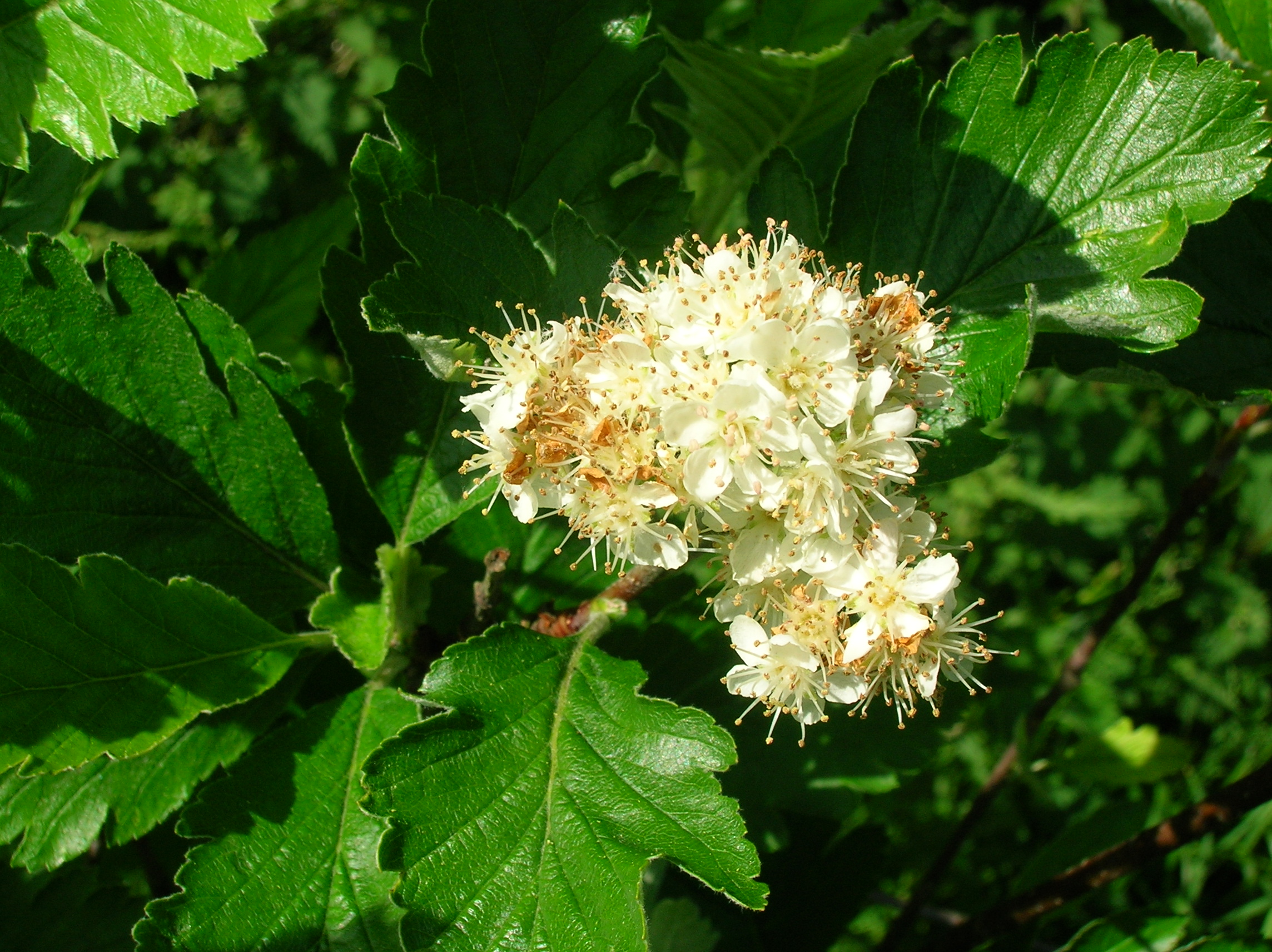
The island has three endemic species of tree, the Arran Whitebeams.[74] These trees are the Scottish or Arran Whitebeam (Sorbus arranensis), the Bastard Mountain Ash or Cut-leaved Whitebeam (Sorbus pseudofennica)[75] and the Catacol Whitebeam (Sorbus pseudomeinichii). If rarity is measured by numbers alone they are amongst the most endangered tree species in the world. They are protected in Glen Diomhan off Glen Catacol, at the north end of the island by a partly fenced off National Nature Reserve, and are monitored by staff from Scottish Natural Heritage. Only 236 Sorbus pseudofennica and 283 Sorbus arranensis were recorded as mature trees in 1980.[76] They are typically trees of the mountain slopes, close to the tree line. However, they will grow at lower altitudes, and are being preserved within Brodick Country Park.
Over 200 species of bird have been recorded on Arran including Black Guillemot, Eider, Peregrine Falcon and the Golden Eagle.[77] In 1981 there were 28 Ptarmigan on Arran, but in 2009 it was reported that extensive surveys had been unable to record any.[78][79] Similarly, the Red-billed Chough no longer breeds on the island.[80]
Red Deer are numerous on the northern hills, and there are populations of Red Squirrel, Badger, Otter, Adder and Common Lizard. Offshore there are Harbour Porpoises, Basking Sharks and various species of dolphin.[77]
Notable residents
- Sir Kenneth Calman, Chancellor of Glasgow University, former Scottish & UK Chief Medical Officer and author of the Calman Commission on Scottish devolution.[81]
- Daniel Macmillan who, with his brother Alexander founded Macmillan Publishers in 1843. Daniel was also the grandfather of Harold Macmillan who became Prime Minister in 1957.
- Jack McConnell, former First Minister of Scotland.
- Robert McLellan, Scots playwright and poet.
- J. M. Robertson, politician and journalist.
See also
- List of islands of Scotland
- Geology of Scotland
- Hutton's Unconformity
- Fauna of Scotland
- Flora of Scotland
Notes
- ^ Downie (1933) p. 38. Downie also offers "Hersey".
- ^ Haswell-Smith, Hamish (2004). The Scottish Islands. Edinburgh: Canongate. pp. 502-03. Modified to include bridged islands. ISBN 1841954543.
- ^ a b c General Register Office for Scotland (28 November 2003) Occasional Paper No 10: Statistics for Inhabited Islands Retrieved 9 July 2007.
- ^ Haswell-Smith (2004) p.11.
- ^ Infobox reference is Haswell-Smith, Hamish (2004). The Scottish Islands. Edinburgh: Canongate. pp. 11-17. unless otherwise stated. ISBN 1841954543.
- ^ a b Haswell-Smith (2004) pp. 11-17.
- ^ a b Iain Mac an Tàilleir (2003). "Placenames" (pdf). Pàrlamaid na h-Alba. http://www.scottish.parliament.uk/vli/language/gaelic/pdfs/placenamesA-B.pdf. Retrieved 2007-07-23.
- ^ Downie (1933) pp. 38–39.
- ^ Keay & Keay (1994) p. 42 refer to "the profile of the 'Sleeping Warrior' of Arran as seen from the Clyde Coast". Various websites claim the phrase refers to single hills, none of which individually resemble a reclining human figure.
- ^ "Arran Page 1" hughspicer.fsnet.co.uk. Retrieved 22 February 2009.
- ^ Downie (1933) p. 2.
- ^ Johnstone et al. (1990) pp. 223-26.
- ^ Haswell-Smith (1994) p. 13.
- ^ a b c "Get-a-map". Ordnance Survey. Retrieved 30 March 2008.
- ^ a b c McKirdy et al. (2007) pp. 297- 301.
- ^ McKirdy et al. (2007) pp. 143, 144, 149.
- ^ The implications of this small chalk outcrop are considerable. It suggests that like much of southern England, Scotland once had considerable deposits of this material that have been subsequently eroded away, although there is no clear-cut evidence of this. See McKirdy et al. (2007) p. 298.
- ^ "Corrie". Undiscovered Scotland. Retrieved 16 January 2010.
- ^ Hall (2001) p. 28
- ^ Keith Montgomery (2003). "Siccar Point and Teaching the History of Geology" (pdf). University of Wisconsin. http://nagt.org/files/nagt/jge/abstracts/Montgomery_v51n5.pdf. Retrieved 26 March 2008.
- ^ "Hutton's Unconformity - Lochranza, Isle of Arran, UK - Places of Geologic Significance on Waymarking.com". Waymarking.com. http://www.waymarking.com/waymarks/WM3F65. Retrieved 20 October 2008. The site was not sufficiently convincing for him to publish his find until the discovery of a second site near Jedburgh.
- ^ Murray (1973) pp. 68-69.
- ^ McKirdy et al. (2007) p. 28.
- ^ Andrew Rogie. "Geology of Arran". http://www.virtual-geology.info/vft/2004-andy/Arran.htm. Retrieved 2008-11-09.
- ^ Downie (1933) pp. 70-71.
- ^ This cave is one of several associated with the legend of Robert the Bruce and the spider. See McKirdy et al. (2007) p. 301.
- ^ Downie (1933) p. 19 records that the Scriden rocks fell "it is said, some two hundred years ago, with a concussion that shook the earth and was heard in Bute and Argyllshire".
- ^ "National Scenic Areas". SNH. Retrieved 30 Mar 2011.
- ^ "Scrol Browser" Scotland's Census Results Online. Retrieved 8 March 2008.
- ^ a b "Regional mapped climate averages" Met Office. Retrieved 4 September 2009.
- ^ Noble (2006) pp. 104–08.
- ^ "Machrie Moor Stone Circles". Undiscovered Scotland. Retrieved 18 July 2009.
- ^ Downie (1933) pp. 29–30.
- ^ "Torr a' Chaisteal Dun". Undiscovered Scotland. Retrieved 18 July 2009.
- ^ Downie (1933) pp. 34–35.
- ^ Downie (1933) pp. 35–37.
- ^ Beare (1996) p. 26.
- ^ Murray (1973) p. 167–71.
- ^ Downie (1933) pp. 38–40.
- ^ "King's Cave: The cave at Drummadoon". showcaves.com. Retrieved 18 July 2009.
- ^ Downie (1933) pp.42–43. He states that the 1406 attack led by the Earl of Lennox "utterly destroyed" the structure.
- ^ Coventry (2008) pp. 53, 255, 551.
- ^ Taylor (1887) vol 2 p. 3.
- ^ Quoted by Haswell Smith (2004) p. 12.
- ^ Mackillop, Dugald "The History of the Highland Clearances: Buteshire - Arran" electricscotland.com. Retrieved 18 July 2009.
- ^ "Lagantuine - Isle of Arran, Ayrshire UK" waymarking.com. Retrieved 18 July 2009.
- ^ "Visits to Crash Sites in Scotland". Peak District Air Accident Research. Retrieved 26 May 2011.
- ^ Haswell Smith (2004) p. 11.
- ^ Mac an Tàilleir, Iain (2004) 1901-2001 Gaelic in the Census (PowerPoint ) Linguae Celticae. Retrieved 1 June 2008.
- ^ a b c d e f g Holmer (1957) p. vii.
- ^ Fleming, D. (2003) Occasional Paper 10 (pdf) General Register Office for Scotland. Retrieved 27 February 2009.
- ^ Ó Dochartaigh (1997) p. 84-85.
- ^ Downie (1933) p. 1 confirms this status at the publication date.
- ^ "District: Cunninghame". ScotlandsPlaces. Retrieved 2 June 2011.
- ^ With respect to Scotland the phrase "unitary authority" is merely descriptive; in the United Kingdom the phrase is a designation that is specific to English local government areas.
- ^ "2007 Election Results Analysis: Table 18" (pdf) scottish.parliament.uk. Retrieved 17 July 2009.
- ^ "Arran: Getting there/around" Caledonian MacBrayne. Retrieved 17 July 2009.
- ^ "Arran coast road reclassified" Arran Coast Road. Retrieved 19 July 2009.
- ^ Downie (1933) p. 5.
- ^ "Arran Bus Timetable 2009" (pdf) Stagecoach. Retrieved 19 July 2009.
- ^ "Auchrannie Resort on the Isle of Arran" www.auchrannie.co.uk. Retrieved 1 March 2008
- ^ "A wee history". Shiskine Golf and Tennis Club. Retrieved 28 Sept 2011.
- ^ Ross, John (27 February 2008). "Fish-farm plan sparks fears for marine reserve". The Scotsman (Edinburgh). http://business.scotsman.com/seafishingindustry/Fishfarm-plan-sparks-fears-for.3818315.jp. Retrieved 22 February 2009.
- ^ "Sun sets on fishing in island bay". BBC News. 21 September 2008. http://news.bbc.co.uk/1/hi/scotland/glasgow_and_west/7628288.stm. Retrieved 25 September 2008.
- ^ "Cask Ales". Arran Brewery. http://www.arranbrewery.co.uk/caskale.asp. Retrieved 3 April 2010.
- ^ "Visitor Centre & Shop". Arran Brewery. http://www.arranbrewery.co.uk/visitor_center.asp. Retrieved 3 April 2010.
- ^ Pearce, Daniel (9 May 2008). "Arran Brewery Company goes into administration". The Publican. http://www.thepublican.com/story.asp?storycode=59694. Retrieved 22 May 2008.
- ^ "UK MPAs" UK MPA Centre. Retrieved 6 October 2010.
- ^ "Marine Conservation" Scottish Government. Retrieved 6 October 2010.
- ^ "Banner goes from strength to strength." (13 April 2007) arranbanner.co.uk. Retrieved 17 July 2009.
- ^ "Voice for Arran" voiceforarran.com. Retrieved 9 July 2010.
- ^ "Monopoly - Isle of Arran Edition" arranmonopoly.com Retrieved 15 April 2010.
- ^ Morris, Johnny (17 March 2006). "Grail Trail". The Daily Telegraph. http://www.telegraph.co.uk/travel/734788/Grail-trail-Aran-sweaters.html. Retrieved 3 August 2007.
- ^ Johnston, Ian (15 June 2007). "Trees on Arran 'are a whole new species'". The Scotsman (Edinburgh). http://news.scotsman.com/scitech.cfm?id=936532007. Retrieved 18 June 2007.
- ^ Donald Rodger, John Stokes & James Ogilve (2006). Heritage Trees of Scotland. The Tree Council. p. 58. ISBN 0-904853-03-9.
- ^ Eric Bignal (1980). "The endemic whitebeams of North Arran". The Glasgow Naturalist 20 (1): 60–64.
- ^ a b "Arran Wildlife". arranwildlife.co.uk. Retrieved 18 July 2009.
- ^ "Iconic Birds at Risk". Sunday Herald (Glasgow). 1 February 2009. Available as Ptarmigan disappearing from southern Scotland
- ^ Downie (1933) p. 132 includes the Ptarmigan in a list of birds no longer extant on the island at that time including the Red Kite, Hobby, White-tailed Sea Eagle, Hen Harrier and Capercaillie.
- ^ "A6.102a Chough Pyrrhocorax pyrrhocorax (breeding)" (pdf) JNCC. Retrieved 1 August 2009.
- ^ "Sir Kenneth Calman - biography" BMA. Retrieved 20 June 2009.
References
- Beare, Beryl (1996) Scotland. Myths & Legends. Avonmouth. Parragon. ISBN 0752516949
- Coventry, Martin (2008) Castles of the Clans. Musselburgh. Goblinshead. ISBN 9781899874361
- Downie, R. Angus (1933) All About Arran. Glasgow. Blackie and Son.
- Hall, Ken (2001) The Isle of Arran. Catrine. Stenlake Publishing. ISBN 9781840331356
- Haswell-Smith, Hamish (2004) The Scottish Islands. Edinburgh. Canongate. ISBN 1841954543
- Holmer, N. (1957) The Gaelic of Arran. Dublin. Dublin Institute for Advanced Studies.
- Johnstone, Scott; Brown, Hamish; and Bennet, Donald (1990) The Corbetts and Other Scottish Hills. Edinburgh. Scottish Mountaineering Trust. ISBN 0907521290
- Keay, J. & Keay, J. (1994) Collins Encyclopaedia of Scotland. London. HarperCollins. ISBN 0002550822
- McKirdy, Alan Gordon, John & Crofts, Roger (2007) Land of Mountain and Flood: The Geology and Landforms of Scotland. Edinburgh. Birlinn. ISBN 9781841583570
- Murray, W.H. (1973) The Islands of Western Scotland. London. Eyre Methuen. SBN 413303802
- Noble, Gordon (2006) Neolithic Scotland: Timber, Stone, Earth and Fire. Edinburgh University Press. ISBN 0748623388
- Ó Dochartaigh, C. (1997) Survey of the Gaelic Dialects of Scotland. Dublin. Dublin Institute for Advanced Studies.
- Taylor, J. (1887) Great Historic Families of Scotland vol 2. London. J.S. Virtue & Co.
External links
- Isle of Arran travel guide from Wikitravel
- Information on the Arran Coastal Way long distance path
- Visitor's guide with news, events, transport and accommodation.
- Arran seen from space, NASA
- The Isle of Arran Heritage Museum
- The Arran Banner Arran's local newspaper
- Arran High School
- The Sleeping Warrior on Flickr
- Arran.info The Isle of Arran Interactive Guide
Arran Main villages 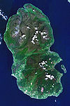
Smaller villages and settlements Mountains and hills Goat Fell · Beinn Tarsuinn · Caisteal Abhail · Cìr Mhòr · Creag Ghlas Laggan · Tighvein · Sleeping WarriorHistory Environment Arran Whitebeams · Glenashdale FallsEconomy The Arran Banner · Arran Single MaltSurrounding islands National Scenic Areas in Scotland The Borders Firth of Clyde and Mainland Argyll North Arran • Knapdale • Kyles of ButeStirling Perth and Kinross Grampians Highland Assynt-Coigach • Ben Nevis and Glen Coe • Dornoch Firth • Glen Affric • Glen Strathfarrar • Kintail • Knoydart • Kyle of Tongue • Loch Shiel • Morar, Moidart and Ardnamurchan • North-West Sutherland • Wester RossHebrides The Cuillin Hills • Jura • Lynn of Lorn • Loch na Keal, Isle of Mull • Scarba, Lunga and The Garvellachs • Small Isles • St Kilda • South Lewis, Harris and North Uist • South Uist Machair • TrotternishNorthern Isles Islands of Scotland Northern Isles 
Hebrides Other Categories:- Islands of the Clyde
- Isle of Arran
- Volcanoes of Scotland
- Paleocene volcanism
- Extinct volcanoes


Wikimedia Foundation. 2010.