- Corsham
-
Coordinates: 51°26′N 2°11′W / 51.43°N 2.19°W
Corsham 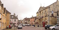
Town hall and post office at the High street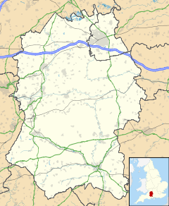
 Corsham
Corsham shown within WiltshirePopulation 10,780 [1] OS grid reference ST869702 Parish Corsham Unitary authority Wiltshire Ceremonial county Wiltshire Region South West Country England Sovereign state United Kingdom Post town Corsham Postcode district SN13 Dialling code 01249 01225 Police Wiltshire Fire Wiltshire Ambulance Great Western EU Parliament South West England UK Parliament Chippenham Website http://www.corsham.gov.uk/ List of places: UK • England • Wiltshire Corsham is a historic market town and civil parish in north west Wiltshire, England. It is at the south western extreme of the Cotswolds, just off the A4 which was formerly the main turnpike road from London to Bristol,[2] between Bath (7.5 miles / 12 kilometres) and Chippenham (4.5 miles / 7 kilometres).
Corsham was historically a centre for agriculture and later the wool industry, and remains a focus for quarrying Bath Stone. It contains several notable historic buildings, such as the stately home of Corsham Court. In World War II and the Cold War, it became a major administrative and manufacturing centre for the Ministry of Defence, with numerous establishments both above ground and in the old quarry tunnels. The early 21st century saw some growth in Corsham's role in the film industry.
Contents
History
Corsham apparently derives its name from Cosa's hām, "ham" being Old English for homestead, or village. The town is referred in the Domesday book as Cosseham; the letter 'R' appears to have entered the name later under Norman influence (possibly caused by the recording of local pronunciation.), when the town is reported to have been in the possession of the Earl of Cornwall.[3] Corsham is recorded as Coseham in 1001, as Cosseha in 1086,[2] and at Cosham as late as 1611 (on John Speed's map of Wiltshire). The Corsham area belonged to the King in Saxon times, the area at the time also had a large forest which was cleared to make way for further expansion.
There is evidence that the town had been known as "Corsham Regis" due to its reputed association with anglo-saxon Ethelred of Wessex,[4][5] and this name remains as that of a primary school.
One of the towns that prospered greatly from Wiltshire's wool trade in mediæval times, it maintained its prosperity after the decline of that trade through the quarrying of Bath stone, with underground mining works extending to the south and west of Corsham.
Numbers 94 to 112 of the High Street are Grade II* listed buildings known as the "Flemish Weavers Houses", however there is little cogent evidence to support this name and it appears more likely to derive from a handful of Dutch workers who arrived in the 17th century.[6]
Corsham also contains the historic Georgian house, The Grove, opposite the high street, a typical example of classic Georgian architecture.
Features
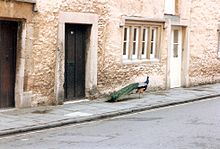 A peacock makes its way along Church Street
Corsham's small town centre includes the Martingate Centre, a late 20th century retail development, which also houses offices and a small teaching facility for Wiltshire College, a further education institution.
The stately home of Corsham Court can also be found in the town centre. Standing on a former Saxon Royal Manor, it is based on an Elizabethan manor home from 1582. Since 1745, it has been part of the Methuen estate. The house has an extensive collection of Old Masters, rooms furnished by Robert Adam and Thomas Chippendale, and parks landscaped by Capability Brown and Humphry Repton. The house is open to the public all year round excluding December and is famed locally for its peacocks, which freely wander about the streets.[7] The owner of Corsham Court in the mid-seventeenth century was the commander of the Parliamentarian New Model Army in Wiltshire; his wife built what came to be known as the Hungerford Almshouses in the centre of town.
Corsham is the site of the disused entrance to Tunnel Quarry, which used to be visible off Pockeredge Drive.
Community
The town has its own festival. Corsham also started a jazz festival (separate from the town festival) in 2004, which included a performance by the National Youth Jazz Orchestra. The event however was not as successful as the organizers would have hoped, bands across the seven venues had to compete with each other and turnout was lower than expected. In 2005 the festival was reduced to just two venues and a much reduced lineup. In 2006, the festival reduced in size once again, with only the Royal Oak Pub hosting the event, and the Stan Tracey Trio as principal headliners.
The local association football club, Corsham Town F.C., were founded in 1884. They finished first in the Western Football League Premier Division in 2007.[8]
Wiltshire Police has a station in the town that is headed by a sergeant, and is a base for five local and rural neighbourhood policing teams.[9]
Pickwick
Pickwick itself was once a separate settlement and now forms the north-western part of the town. The name derives from Anglo-Saxon pic (meaning a peak or pointed hill) and wic (village). The Wiltshire Hundred Roll of 1273 refers to a "William de Pikewicke".[3]
Corsham was the inspiration for Charles Dickens' novel The Pickwick Papers; it is thought that he borrowed the name from Moses Pickwick, a coachman who was born in Pickwick, lived in the "Hare and Hounds" inn,[10] and ran coaches between Bath and London.[11][12]
Pickwick Manor was noted by architectural historian Nikolaus Pevsner as an "unusually impressive example of a late 17th century manor house", having remnants of a 14th century wing.[13] More recently it has been the residence of architect Harold Brakspear and his descendants.[2][14]
Beechfield is a late Georgian house in Middlewick Lane. It was extended in the early 1970s to provide additional accommodation[13] The house itself was split into residential accommodation while part of the grounds were split off in 2002 under the auspices of the Town Council to provide a Nature Area where local flora and fauna can be seen.[15]
Middlewick House was occupied by Camilla Parker Bowles and her husband between 1986 and 1995, when it was bought by Nick Mason of Pink Floyd.[16]
Pickwick is also noted for "The Two Pigs", a real ale pub which is a Grade II listed building.[17] Formerly named "The Spread Eagle",[18] it is now known for hosting live music, but t the end of the nineteenth century - when Pickwick did not have a mortuary - corpses were laid out on the bar of the pub until they could be transferred to Corsham mortuary.[10]
Neighbouring villages
Corsham Town Council's civil parish boundaries include several neighbouring settlements: Broadstone, Chapel Knap, Easton, Gastard, Hartham, Leafield, The Linleys, Neston, The Ridge, Thingley, part of Rudloe, and a small part of Chippenham south of the A4 road.[19]
Hartham Park is a Georgian estate that includes a rare stické court.
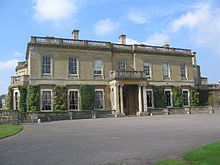
Neston village was established around Neston Park, a country estate whose house was built c.1790.[2] Neston Park is home of the Fuller family, who give their name to the Fuller, Smith and Turner brewery in London, known for Fuller's London Pride cask ale.[20]
Local government
When the Local Government Act 1972 came into force on 1 January 1974, Corsham came within the areas of Wiltshire County Council and North Wiltshire District Council, electing one county councillor[21] and three district councillors from the Corsham and Lacock division.[22] On 1 April 2009, Wiltshire became a unitary authority managed by Wiltshire Council and the county's district councils were all merged into this body.[23] From 2009, Corsham elects three councillors to the new authority, one from each of three new single-member electoral divisions:[24]
- Corsham Pickwick and Rudloe,
- Corsham Town, and
- Corsham Without and Box Hill (which includes neighbouring Lacock and part of Box.)
Corsham's lowest level of government is Corsham Town Council, which was founded as a parish council in 1895. Although Corsham never had its own town charter, in May 2000 it became a town council.[25] There are currently twenty councillors, and the four council committees are
- Finance and General Purposes - general policy, finances, Christmas lights and "Corsham in Bloom"
- Leisure - children's play areas, recreation grounds and allotments
- Amenities - Town Hall maintenance, cemetery, footpaths etc.
- Planning - the council is not itself the planning authority for Corsham but makes recommendations to Wiltshire Council on applications.
Corsham made headlines in April 2007 when a British National Party candidate was elected unopposed to the council.[26]
Population and demographics
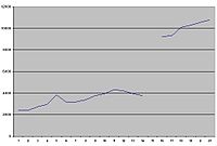 Changes in Corsham's population 1801 - 2001
The first official census of 1801 showed Corsham having 2,402 inhabitants, while the most recent of 2001 lists 10,780. No census was taken in 1941 due to the Second World War, but the rise in population (from 3,754 in 1931 to 9,268 in 1951, a rise of 147%) is attributable to the influx of military personnel.[27] The increase shown for 1840 is due the influx of stone workers and the arrival of the Great Western Railway.[2]
The 2001 census demographics of the SN13 postcode area, of which Corsham comprises the major part, do not differ markedly from national figures; the unemployment rate is 2.0 per cent compared to a national 3.2 per cent, and there is a marginally higher rate of retirees (at 23.3 per cent as against 22 per cent). 23 per cent of adults are educated to degree level, against a national average of 20 per cent.[28]
Education
The education authority for Corsham and its surrounding area is Wiltshire County Council, which maintains seven primary schools and one secondary school. The primary schools, catering for students up to age 11 are
- Box Church of England Primary School, High Street, Box. Founded in 1875 as an elementary board school, it now has about 170 pupils.[29]
- Corsham Primary School, split between Pound Pill, and Broadwood Avenue, Corsham, was formed from the origins of Lady Methuen’s School for Girls (founded 1816), The National School for Girls (c.1840s) and Corsham British School For Boys (c. 1840). These schools came under the aegis of the Corsham School Board in 1893 and were finally merged in 1923. It now provides for about 540 students.[30]
- Corsham Regis School, Kings Avenue, Corsham, opened in 1943 for the children of incoming military workers. It became specifically a junior school in 1955 when older children transferred to the Corsham Secondary Modern School, and now has about 180 students. It has 7 classrooms and a nursery called ABC.[31]
- Lypiatt Primary School near Neston, to the south of Corsham itself, and was opened in 1951 to cater for children of Ministry of Defence employees; it now has about 16 students.[32]
- Neston Primary School, Church Rise, Neston, was founded in 1861 as Corshamside School. It now provides for about 170 students.[33]
- Shaw Church of England (Controlled) Primary School in Corsham Road, Shaw, Melksham, takes pupils from Corsham. Founded in the 1840s, it expanded over the years as an elementary school until 1953, when a secondary school opened in Melksham and Shaw became a primary school. It now has about 185 students.[34]
- St Patrick's Catholic Primary School, Lacock Road, Corsham, opened in 1966 and now has about 200 pupils.[35]
- The Corsham School, The Tynings, is Corsham's only secondary school; it was opened in 1972 as a comprehensive school and is now a specialist Visual Arts and Maths and Computing College with approximately 1400 students.[36][37] Catering for students from 11 to 18, its DCSF educational statistics are generally better than for Wiltshire as a whole.[38] Its most recent Ofsted inspection, in 2009, assessed it as Outstanding in most areas.[39]
- The Heywood Preparatory School, Priory Street, is an independent school providing education from ages 3 to 11, and has about 190 pupils.[40] It achieved a favourable assessment when last inspected in June 2008, being described as "successful in meeting its aims and outstandingly so in many areas. It meets the needs of all pupils who are well educated in the widest sense".[41] Itis located on two acres of property in the centre of Corsham, near Corsham Court, and was first mentioned in the Domesday Book as a priory donated to an order of monks.The building itself is a Grade II Georgian building built in Bath stone in 1776, later additions include a barn, used as a dining room and later a science block and multi-functional performance hall built in the previous decade. The school is owned by Michael and Pamela Hall, who are the bursar and headteacher respectively who bought it in 1993.[42][43][44] The school was rated 95th in The Sunday Times Good Schools Guide, previously it was 115th.
Churches
Corsham Priory was referred to in 1336 as having been given to Marmoutier Abbey during the time of Henry I (1068–1135) as an alien priory.[45] An unnamed prior was referred to in 1201, but the priory itself had become inactive by 1294 and its lands passed to The Crown and eventually to King's College, Cambridge.[45] The site later became that of a Georgian house, which is now The Heywood School.
Anglican
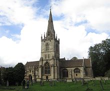 Church of St Bartholomew
The town and surrounding villages are within the jurisdiction of the Diocese of Bristol.
- The Church of St Bartholomew is of Saxon origin; it lies between the High Street and Corsham Court. The fabric has been extended numerous times since its foundation, and in 1810 the spire was removed as a danger but not replaced until 1874.[46] In the north chancel chapel, the large altar tomb of Thomas Tropenell is shared with his first wife, Agnes.[47]
- The Church of St. John the Baptist, Gastard dates back to 1428 but the current building only to 1912. It is built in the gothic style.[48]
- The Church of St. Philip and St. James, Neston is part of the parish of Neston. Opened in 1866, its architecture is early English constructed of local stone.[49]
Roman Catholic
- St. Patrick's Roman Catholic Church was originally Pickwick School, then a glove factory, before becoming a gas mask factory during the Second World War. It was converted into a church to provide for incoming military workers.[50] It did not have a resident priest between the Reformation and 1957.[51]
Free Church
- The Congregational Church, Pickwick Road, originally met in a malthouse, and a new building was commenced in 1790. In 1971 it closed and is now used for offices.[53]
- Ebenezer Baptist Chapel, Velly, was founded in 1857.[54]
- Ebenezer Chapel, Priory Street, was formed in 1822/3 when some members of the Congregational Church split over doctrine. The present building opened in 1829 and has been extended since then.[55]
- Monk's Lane Chapel, built in 1662, was formerly a Quaker meeting-house and was transferred to the Congregational church in 1690.[56][57]
- The Particular Baptist Chapel, Pound Pill dates back to about 1824.[58]
- The Brethren met in several locations, beginning in the mid nineteenth century at Pockeridge Lodge, moving to Neston, while another group met in Pickwick. By 1903, both were meeting in Neston and in 1925 they bought the Primitive Methodist Chapel, Station Road.[59][60]
- Wesleyan Methodist Chapel, Pickwick Road, replaced a cottage in Easton, and a house in Middlewick Lane, before the present chapel was built in 1903.[61]
- Zion Hill Baptist Chapel was built in 1859 by a group who separated from the Priory Street Ebenezer Chapel.[62]
Transport
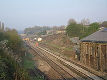 There is a local campaign to reopen the railway station near Station Road
Corsham is connected to Bradford on Avon by the B3109 road, to Melksham by the B3353, and to Chippenham and Bath by the A4 Bath Road, a former turnpike from London to Bristol. Four public car parks in the town centre are operated by North Wiltshire District Council for a small fee.[63] Bus companies, including Coachstyle, Faresaver and FirstGroup plc, operate local services, as well as buses to all nearby towns.[63]
The Great Western Main Line railway from London to Bristol passes through Corsham, though the local station closed in the 1960s. Nearby stations, and most passenger trains, are operated by First Great Western. Some local services call at the nearest station at Melksham (4.5 miles, 7.2 km) while Chippenham station (4.7 miles, 7.5 km) offers frequent express services and connections. The eastern portal of Box Tunnel, built as the longest railway tunnel of its time, by Isambard Kingdom Brunel for the Great Western Railway, is at Hudswell on the western edge of the town. Corsham Railway Cutting carries the main line westward through Corsham to Box Tunnel; in 1971 6.6 hectares (16 acres) of land in the cutting were designated a Site of Special Scientific Interest for notable geology.
Town twinning
Corsham has had a twinning relationship with the town of Jargeau, France since 1981,[64] and has an active twinning association.[65] Corsham holds an annual twinning event in which musical and charity events occur, accompanied by French food and wines. There is also a boules competition for the Peter Henderson trophy which is named in memory of a local doctor and former chairman of the twinning association.[66] As part of the 2008 event, a mock Storming of the Bastille was staged to celebrate Bastille Day, Corsham Town Hall standing in for the Parisian prison.[67]
Economy
Defence
The Ministry of Defence has operated a number of locations in the vicinity of Corsham since the First World War and employs approximately 2,000 people:[68]
Basil Hill site
The Basil Hill Site is in Park Lane and comprises the former Basil Hill Barracks; approximately 800 personnel are employed there, rising to 2,100 in 2010 as part of a major modernisation programme named "Corsham New Environment". It is home to the Directorate of Information Systems and Services (DISS) and also houses the Global Operations Security Control Centre (GOSCC). Completion of Corsham New Environment will see the Rudloe and Copenacre sites relinquished by the Ministry of Defence.[68]
Rudloe Manor site
 Rudloe manor[69]
The Rudloe Site was formerly RAF Rudloe Manor, which was established during the Second World War as a non-flying station for administrative and command & control purposes. It was home to HQ Number 10 Fighter Group, RAF Regional Command, Headquarters RAF Police & Security Services, No 1 Signals Unit, Controller Defence Communications Network and 1001 Signals Unit. By 1998 it had become mostly administrative, housing the RAF Provost and Security Services, which dealt with security and criminal investigation services, the Defence Communication Services Agency, while the detachment of 1001 Signals Unit of the RAF remained.[70] It closed as an operational site in about 2000.[71]
RAF Rudloe Manor was the location of Headquarters Southern Area Royal Observer Corps from 1952 until 1980 when it was relocated to Lansdown near Bath. Co-located with the ROC was Headquarters Southern Sector United Kingdom Warning and Monitoring Organisation responsible for the now defunct Four-minute warning in the event of nuclear attack during the Cold War.
Copenacre site
The Copenacre Site was originally an underground stone quarry below land formerly part of the Hartham estate; this was taken over by the Ministry of Defence in 1937 and became the Royal Naval Stores Depot, Copenacre. It closed on 30 September 1995.[72]
The Copenacre Site closed in January 2011 and was put up for sale.
Hawthorn site
Hawthorn was a development of the Bath stone quarries for defence purposes, originally intended for the underground manufacture of engines for the Hawthorn aeroplane by the Bristol Aeroplane Company[2] and includes the Central Government War Headquarters, variously known as "Turnstile" or "Burlington", and the Central Ammunition Depot.
Other units
- Corsham Computer Centre
Main article: Corsham Computer Centre- Joint Service Unit
- Provides administrative support & facilities management in all three locations. In 2006 a Private Finance Initiative contract was let to Inteq for the renewal and expansion of the Basil Hill and Rudloe Site facilities, valued at around £800m.[73]
- Services Cotswold Centre
- A welfare service in Neston offering temporary accommodation for services families who require it, and has 63 family units. It also has a medical centre and other amenities.[74]
- HMS Royal Arthur
Main article: HMS Royal Arthur (shore establishment)- This was a Royal Navy training establishment; during the Second World War it had been based at a Butlins holiday camp at Ingoldmells, near Skegness, but moved to Corsham in 1947.
- Skynet
The UK military communications satellite constellation called Skynet, a PFI arrangement, is controlled by contractor, Paradigm Services, from the location of the former 1001 SU Det on Skynet Drive. The ground segments in support of the constellation are located at Bordon, Hampshire and Colerne Airfield, Colerne, Wiltshire (formerly RAF Oakhanger and RAF Colerne.)
- Others
A number of defence-related contractors are either co-located or in the vicinity of the MOD sites, such as Chemring Energetics UK Limited[75] and Serco Defence, Science and Technology.
Quarries
See also: Bath Stone#QuarriesUnderground extraction of Bath Stone continues in Corsham on a smaller scale than previously. Hanson plc operates Hartham Park Quarry in the Hudswell district, southwest of Pickwick, and Monk's Park Quarry near Gastard.
Disused quarries have been redeployed for other purposes; apart from defence usage, there is a wine storage facility at Eastlays, near Gastard,[76] and storage of magnetic media for off-site data protection at Neston.[77]
Film and television
Another use for the quarries is the film industry. Underground scenes from the first episode of Blake's Seven were filmed at Eastlays,[78] and disused tunnels form part of the studio complex of Corsham Media Park, a specialist business park that opened in 2001 adjacent to RAF Rudloe Manor.[79]
Period drama location filming occurs in Corsham, as in neighbouring Lacock and Atworth parishes. Neston Park hosted major outdoor film sets for the 2008 BBC television adaption of Lark Rise to Candleford, and the BBC also filmed scenes for a 2008 version of Tess of the D'Urbervilles in Church Street and Corsham Court grounds.[80][81]
Corsham Court has also been used as a period location in productions such as Barry Lyndon (1975),[82] The Remains of the Day (1993), A Respectable Trade (1997) and Wives and Daughters (1999).[83]
Notable people
- Felix Aylmer (1889–1979), Actor. President of Equity 1950-1969
- Jennifer Biddall (b. 1980), actress, best known as Jessica Harris in Hollyoaks
- Camilla Parker Bowles (b. 1947), and her first husband Andrew Parker Bowles
- Harold Brakspear (1870–1934), restoration architect and archæologist, lived at Pickwick Manor and Parkside in High Street
- Robert Brian (b.1970), drummer and session musician, most notably for Siouxsie Sioux
- Revd Richard Enraght (1837–1898), religious controversialist, curate of St Bartholomew's Church, Corsham, 1861–1864
- Sir Gabriel Goldney, 1st Baronet of Beechfield (1813–1900), MP for Chippenham, and the Goldney Baronets
- Edward Hasted (1732–1812), historian, master of Corsham Almshouse[2]
- Elizabeth Hurley (b. 1965), actress, attended St Patrick's Primary School, 1973-74[84]
- Nick Mason (b. 1944), musician, Pink Floyd
- Baron Methuen, family seat is Corsham Court[2]
- Gavin Schmidt, climatologist, GISS[85]
- Rini Templeton (1935–1986), artist, studied at Bath Academy in Corsham c. 1956
- Michael Tippett (1905–1998), composer, lived at Parkside in High Street, 1960-70[2]
Gallery
-
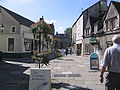
The historic High Street is typical of a Cotswold town
-
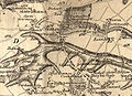
A 1773 map shows Neston's earlier name of Corsham Side[86]
-
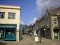
The southern portion of the High Street is pedestrianized
See also
Neighbouring civil parishes (anticlockwise from the north):
- Biddestone – small village north of Hartham
- Colerne – medium-sized village northwest of Corsham and Pickwick
- Box – village west of Corsham; parish includes part of Rudloe
- Atworth – Neston Park Estate extends south beyond Atworth village
- Lacock – historic village and abbey, largely owned by the National Trust, east of Gastard
- Chippenham and Chippenham Without parishes – market town northeast of Easton
References
- ^ "Census Information". Wiltshire Council. 2001. http://history.wiltshire.gov.uk/community/getcensus.php?id=84. Retrieved 2010-11-08.
- ^ a b c d e f g h i "Corsham at Wiltshire Community History". http://history.wiltshire.gov.uk/community/getcom.php?id=71. Retrieved 2010-11-08.
- ^ a b Longstaff, John G. (1911). Notes of Wiltshire Names, Vol. 1 - Place names. Bradford on Avon: Library Press.
- ^ Gazetteer of the British Isles, John Bartholomew
- ^ Ramsay, James (1898). The Foundations of England or, Twelve Centuries of British History. Swan Sonnenschein & Co.. p. 375. http://www.questia.com/PM.qst?a=o&d=100052033.
- ^ "Wiltshire Community History FAQs". http://history.wiltshire.gov.uk/community/getfaq.php?id=21. Retrieved 2010-11-08.
- ^ "Corsham Net - Welcome". 6 April 2007. Archived from the original on 2007-04-06. http://web.archive.org/web/20070406092426/http://www.corshamtown.co.uk/index.html. Retrieved 2008-07-14.
- ^ "Corsham Town Football Club - Club History". http://www.corshamtownfc.co.uk/ClubHistory.htm. Retrieved 2008-07-13.
- ^ Katie Adams (2008-04-12). "New sergeant at Corsham". Wiltshire Times. http://www.wiltshiretimes.co.uk/news/corsham/display.var.2182223.0.new_sergeant_at_corsham.php. Retrieved 2008-04-16.
- ^ a b Flavin, Steve (1991). Corsham Born and Bred. Market Drayton: S.B. Publications. ISBN 1.870708.86.5.
- ^ Mee, Arthur (1939). The King's England: Wiltshire. London: Hodder & Stoughton. ISBN 0340001070.
- ^ "Wiltshire History Questions". 21 October 2002. http://history.wiltshire.gov.uk/community/getfaq.php?id=22. Retrieved 2010-11-08.
- ^ a b Pevsner, Nikolaus (1963). The Buildings of England: Wiltshire. Penguin Books. ISBN 0140710264.
- ^ Brakspear, Sir; Harold (b. Corsham, Wilts. 10 March 1870 - d. 20 November 1934). Who's Who 2006 and Who Was Who 1897-2005 (2005). Retrieved 10 October 2006. Available from xreferplus.
- ^ "Welcome To Corsham Council". www.corsham.gov.uk. http://www.corsham.gov.uk/nature_areas.html. Retrieved 2010-11-08.
- ^ "County at heart of a Prince's romance". Swindon Advertiser. 17 February 2005. http://archive.thisiswiltshire.co.uk/2005/2/17/93497.html. Retrieved 2008-07-25.
- ^ "The Two Pigs". http://www.the2pigs.info/location.htm. Retrieved 2008-06-30.
- ^ "Ye Olde Pubs". http://www.baacorsham.co.uk/yeoldepubs.htm. Retrieved 2008-06-30.
- ^ election-maps.co.uk, Corsham Civil Parish boundary on Ordnance Survey 1:50 000 colour raster layer. Retrieved on October 10, 2006.
- ^ The History of Fuller, Smith & Turner P.L.C. from the brewery's website. Retrieved on October 4, 2006.
- ^ "Councillor by Division". Archived from the original on 2008-02-16. http://web.archive.org/web/20080216083124/http://www.wiltshire.gov.uk/council-and-democracy/councillors-general-information/councillor-by-division.htm. Retrieved 2008-07-18.
- ^ "Councillors by Ward". web.archive.org. Archived from the original on 2007-08-07. http://web.archive.org/web/20070807145124/http://www.northwilts.gov.uk/index/council-democracy/democracy_and_elections/cd_councils-councillors/councillors_by_ward.htm. Retrieved 2010-11-10.
- ^ "Towards One Council". Archived from the original on 2008-05-17. http://web.archive.org/web/20080517004320/http://www.wiltshire.gov.uk/council/local-government-white-paper.htm. Retrieved 2008-07-18.
- ^ election-maps.co.uk, Corsham electoral division boundaries on Ordnance Survey 1:50 000 colour raster layer. Retrieved on July 21, 2009.
- ^ "Welcome To Corsham Council". www.corsham.gov.uk. http://www.corsham.gov.uk/history.html. Retrieved 2010-11-10.
- ^ "BNP seat in 'non-political' town". BBC News. 30 April 2007. http://news.bbc.co.uk/1/hi/england/wiltshire/6582729.stm. Retrieved 2008-07-25.
- ^ "Census Information - Corsham". Wiltshire Council. http://history.wiltshire.gov.uk/community/getcensus.php?item=Corsham. Retrieved 2010-11-10.
- ^ "Demographic data for SN13 (Corsham)". www.mouseprice.com. http://www.mouseprice.com/AreaGuide/Demographics.aspx?PostCodeDistrict=SN13&PostCodeDistrictName=Corsham&PostCode=. Retrieved 2008-08-06.
- ^ "Box Church of England Primary School". Wiltshire Council. http://php.wiltshire.gov.uk/dirschool/getschool.php?id=56. Retrieved 2010-11-10.
- ^ "Corsham Primary School". Wiltshire Council. http://php.wiltshire.gov.uk/dirschool/getschool.php?id=9. Retrieved 2010-11-10.
- ^ "Corsham Regis School". Wiltshire Council. http://php.wiltshire.gov.uk/dirschool/getschool.php?id=12. Retrieved 2010-11-10.
- ^ "Lypiatt Primary School". Wiltshire Council. http://php.wiltshire.gov.uk/dirschool/getschool.php?id=10. Retrieved 2010-11-10.
- ^ "Neston Primary School". Wiltshire Council. http://php.wiltshire.gov.uk/dirschool/getschool.php?id=11. Retrieved 2010-11-10.
- ^ "Shaw Church of England (Controlled) Primary School". Wiltshire County Council. http://php.wiltshire.gov.uk/dirschool/getschool.php?id=104. Retrieved 2010-11-10.
- ^ "St Patrick's Catholic Primary School". Wiltshire Council. http://php.wiltshire.gov.uk/dirschool/getschool.php?id=162. Retrieved 2010-11-10.
- ^ "Corsham School". Wiltshire Council. http://php.wiltshire.gov.uk/dirschool/getschool.php?id=188. Retrieved 2010-11-10.
- ^ "Corsham School website". http://www.corsham.wilts.sch.uk/. Retrieved 2008-09-06.
- ^ "The Corsham School A Visual Arts College". DCSF. http://www.dcsf.gov.uk/cgi-bin/performancetables/school_06.pl?Mode=Z&No=8654066&Type=LA&Num=865&Phase=1&Year=06&Base=b. Retrieved 2008-08-12.
- ^ "The Corsham School A Visual Arts College". www.ofsted.gov.uk. http://www.ofsted.gov.uk/oxedu_reports/display/(id)/106674. Retrieved 2010-10-14.
- ^ "Heywood Preparatory School, Corsham, Wiltshire, Independent Schools". www.isc.co.uk. http://www.isc.co.uk/school_HeywoodPreparatorySchool_Corsham.htm. Retrieved 2008-08-12.
- ^ "Report says school is outstanding in many areas". Wiltshire Times. 12 September 2008.
- ^ http://www.isc.co.uk/school_HeywoodPreparatorySchool_Corsham.htm
- ^ http://www.isi.net/School.aspx?s=6538
- ^ http://www.schoolsnet.com/uk-schools/school-details-reviews/wiltshire/heywood-preparatory-school/16180339/0/213494.html
- ^ a b Pugh, R.B.; Elizabeth Crittall (1956). Victoria History of Wiltshire. 3. http://www.british-history.ac.uk/report.aspx?compid=36576. Retrieved 2009-03-03.
- ^ "Church of St. Bartholomew, Corsham". Wiltshire Council. http://history.wiltshire.gov.uk/community/getchurch.php?id=285. Retrieved 2010-10-10.
- ^ Thomas Dingley, John Gough Nichols, Vincent Brooks, History from marble, vol. 97 (1868), p. 151
- ^ "Church of St. John the Baptist, Corsham". Wiltshire Council. http://history.wiltshire.gov.uk/community/getchurch.php?id=296. Retrieved 2010-10-10.
- ^ "Church of St. Philip and St. James, Neston". Wiltshire Council. http://history.wiltshire.gov.uk/community/getchurch.php?id=297. Retrieved 2010-11-10.
- ^ "St. Patrick's Roman Catholic Church". Wiltshire Council. http://history.wiltshire.gov.uk/community/getchurch.php?id=415. Retrieved 2010-11-10.
- ^ "About Our Parish". http://www.stpatricks-corsham.org.uk/history.aspx. Retrieved 2008-08-15.
- ^ "Baptist, Corsham". Wiltshire Council. http://history.wiltshire.gov.uk/community/getchurch.php?id=289. Retrieved 2010-11-10.
- ^ "Congregational Church, Pickwick Road". Wiltshire Council. http://history.wiltshire.gov.uk/community/getchurch.php?id=286. Retrieved 2010-11-10.
- ^ "Ebenezer Baptist Chapel". Wiltshire Council. http://history.wiltshire.gov.uk/community/getchurch.php?id=290. Retrieved 2010-11-10.
- ^ "Ebenezer Chapel". Wiltshire Council. http://history.wiltshire.gov.uk/community/getchurch.php?id=287. Retrieved 2010-11-10.
- ^ "Society of Friends, Monk's Lane". Wiltshire Council. http://history.wiltshire.gov.uk/community/getchurch.php?id=292. Retrieved 2010-11-11.
- ^ "Monk's Lane Chapel". Wiltshire Council. http://history.wiltshire.gov.uk/community/getchurch.php?id=293. Retrieved 2010-11-10.
- ^ "Particular Baptist Chapel". Wiltshire Council. http://history.wiltshire.gov.uk/community/getchurch.php?id=288. Retrieved 2010-11-10.
- ^ "Primitive Methodist Chapel". Wiltshire Council. http://history.wiltshire.gov.uk/community/getchurch.php?id=332. Retrieved 2010-11-10.
- ^ "The Brethren". Wiltshire Council. http://history.wiltshire.gov.uk/community/getchurch.php?id=295. Retrieved 2010-11-10.
- ^ "Wesleyan Methodist Chapel". Wiltshire Council. http://history.wiltshire.gov.uk/community/getchurch.php?id=294. Retrieved 2010-11-10.
- ^ "Zion Hill Baptist Chapel". Wiltshire Council. http://history.wiltshire.gov.uk/community/getchurch.php?id=291. Retrieved 2010-11-10.
- ^ a b Connect Corsham, Corsham Town Council newsletter, Issue 8, Autumn 2006.
- ^ "Twinning should be for young and old". Swindon Advertiser. 24 March 2005. http://archive.swindonadvertiser.co.uk/2005/3/24/90755.html. Retrieved 2008-07-15.
- ^ "Corsham Twinning Association". http://corshamtwinning.co.uk. Retrieved 2010-12-23.
- ^ "Festival marks French first". Salisbury Journal. 30 June 2000. http://archive.salisburyjournal.co.uk/2000/6/30/242615.html. Retrieved 2008-07-15.
- ^ Katie Adams (7 July 2008). "Mock attack on town hall". ThisIsWiltshire.
- ^ a b "REDEVELOPMENT OF BASIL HILL SITE, CORSHAM" (PDF). http://planning.northwilts.gov.uk/DocsOnline/16198_25.pdf. Retrieved 2008-08-04.
- ^ photo by David Hawkins
- ^ "House of Commons Hansard Written Answers for 2 Jul 1998 (pt 10)". HMSO. http://www.parliament.the-stationery-office.co.uk/pa/cm199798/cmhansrd/vo980702/text/80702w10.htm. Retrieved 2008-08-04.
- ^ "RSG: Sites: RAF Rudloe Manor No 1 Site - WW2 10 Group Operations Block & ROC/UKWMO Southern Sector Control". Subterranean Britain. http://www.subbrit.org.uk/rsg/sites/r/rudloe_manor_1/index.html. Retrieved 2008-08-04.
- ^ "Wiltshire County Council - Wiltshire Community History Get Community Information". Wiltshire County Council. Archived from the original on 2008-05-24. http://web.archive.org/web/20080524081727/http://www.wiltshire.gov.uk/community/getcom.php?id=71. Retrieved 2008-08-04.
- ^ Evry, Craig (25 October 2006). "£800m to be spent on military base". Wiltshire Times. http://www.wiltshiretimes.co.uk/news/corsham/display.var.986965.0.800m_to_be_spent_on_military_base.php. Retrieved 2006-10-02.
- ^ "Services Cotswold Centre, Corsham". http://www.mod.uk/DefenceInternet/DefenceFor/ServiceCommunity/TheServicesCotswoldCentre.htm. Retrieved 2008-08-15.
- ^ formerly Leafield Engineering Ltd
- ^ "Corsham Cellars at Octavian Vaults". http://www.octavianvaults.co.uk/corshamcellars.html. Retrieved 2008-03-16.
- ^ "Storage and Retrieval". Wansdyke Security Limited. http://www.wansdyke.co.uk/storage-and-retrieval.html. Retrieved 2008-03-16.
- ^ "Secret Underground Cities". http://www.monkton-farleigh.co.uk/sc_eastlays1.htm. Retrieved 2008-06-30.
- ^ "£50 Million Media Park opens". 4rfv.co.uk. 2001-09-11. http://www.4rfv.co.uk/industrynews.asp?id=2943. Retrieved 2008-04-16.
- ^ "Town switches centuries". Gazette and Herald. 2008-04-10. http://www.gazetteandherald.co.uk/news/corshamheadlines/display.var.2187261.0.town_switches_centuries.php. Retrieved 2008-04-16.
- ^ Scott McPherson (2008-03-11). "Lark Rise returning". Gazette and Herald. http://www.gazetteandherald.co.uk/search/display.var.2110944.0.lark_rise_returning.php. Retrieved 2008-04-16.
- ^ "Film locations for Barry Lyndon (1975)". www.movie-locations.com. http://www.movie-locations.com/movies/b/BarryLyndon.html. Retrieved 2010-11-10.
- ^ "Tv & Film locations, from castles to manor houses, the moors to seascapes, city streets to villages: www.visitsouthwest.co.uk". web.archive.org. Archived from the original on 2008-01-07. http://web.archive.org/web/20080107210252/http://www.westcountrynow.com/main/film_tv/filmtvhome.cfm. Retrieved 2010-11-10.
- ^ "Hurley school celebrates anniversary". Wiltshire Times. 29 June 2007. http://archive.salisburyjournal.co.uk/2007/6/29/326745.html. Retrieved 2008-07-12.
- ^ "Nasa Expert Returns to His Home Town". Bath Chronicle. 27 August 2009.
- ^ courtesy Wiltshire County Council Libraries & Heritage
Further reading
- McCamley, Nick (2000) Secret underground cities : an account of some of Britain's subterranean defence, factory and storage sites in the Second World War, Pen and Sword Books Ltd[1], ISBN 0-85052-733-3
External links
- Corsham Town Council
- Corsham at Wiltshire Community History from Wiltshire County Council
- Historic Corsham photos at BBC Wiltshire
- Subterranea Britannica – entry on the Corsham bunkers
- Wiltshire's Secret Underground City: Burlington Articles, interactive map and video tour from BBC Wiltshire
Ceremonial county of Wiltshire Unitary authorities - Swindon
- Wiltshire Council
Major settlements - Amesbury
- Bradford on Avon
- Calne
- Chippenham
- Corsham
- Cricklade
- Devizes
- Highworth
- Larkhill
- Ludgershall
- Malmesbury
- Marlborough
- Mere
- Melksham
- Royal Wootton Bassett
- Salisbury
- Swindon
- Tidworth
- Tisbury
- Trowbridge
- Warminster
- Westbury
- Wilton
See also: List of civil parishes in Wiltshire
Rivers Topics - Flag
- Grade I listed buildings
- History
- Lords Lieutenant
- Deputy Lieutenants
- High Sheriffs
- Parliamentary constituencies
- Local elections
- Places
- Museums
- Corsham at the Open Directory Project
Categories:- Towns in Wiltshire


Wikimedia Foundation. 2010.