- Barakar River
Geobox River
name = Barakar River
native_name =
other_name =
other_name1 =
image_size =
image_caption =
etymology =
country = India
country1 =
state = Jharkhand
state1 = West Bengal
region =
region1 =
district =
district1 =
city =
city1 =
landmark = Tilaya Dam
landmark1 = Maithon Dam
length = 225
watershed =
discharge_location = Damodar River
discharge =
discharge_max =
discharge_min =
discharge1_location =
discharge1 =
source_name = Padma, Hazaribagh
source_location =
source_district = Hazaribagh district
source_region = Chota Nagpur Plateau
source_state = Jharkhand
source_country =
source_lat_d =
source_lat_m =
source_lat_s =
source_lat_NS =
source_long_d =
source_long_m =
source_long_s =
source_long_EW =
source_elevation =
source_length =
mouth_name =
mouth_location =
mouth_district =
mouth_region =
mouth_state =
mouth_country =
mouth_lat_d =
mouth_lat_m =
mouth_lat_s =
mouth_lat_NS =
mouth_long_d =
mouth_long_m =
mouth_long_s =
mouth_long_EW =
mouth_elevation =
tributary_left = Usri River
tributary_left1 =
tributary_right = Barsoti River
tributary_right1 =
free_name =
free_value =
map_size =
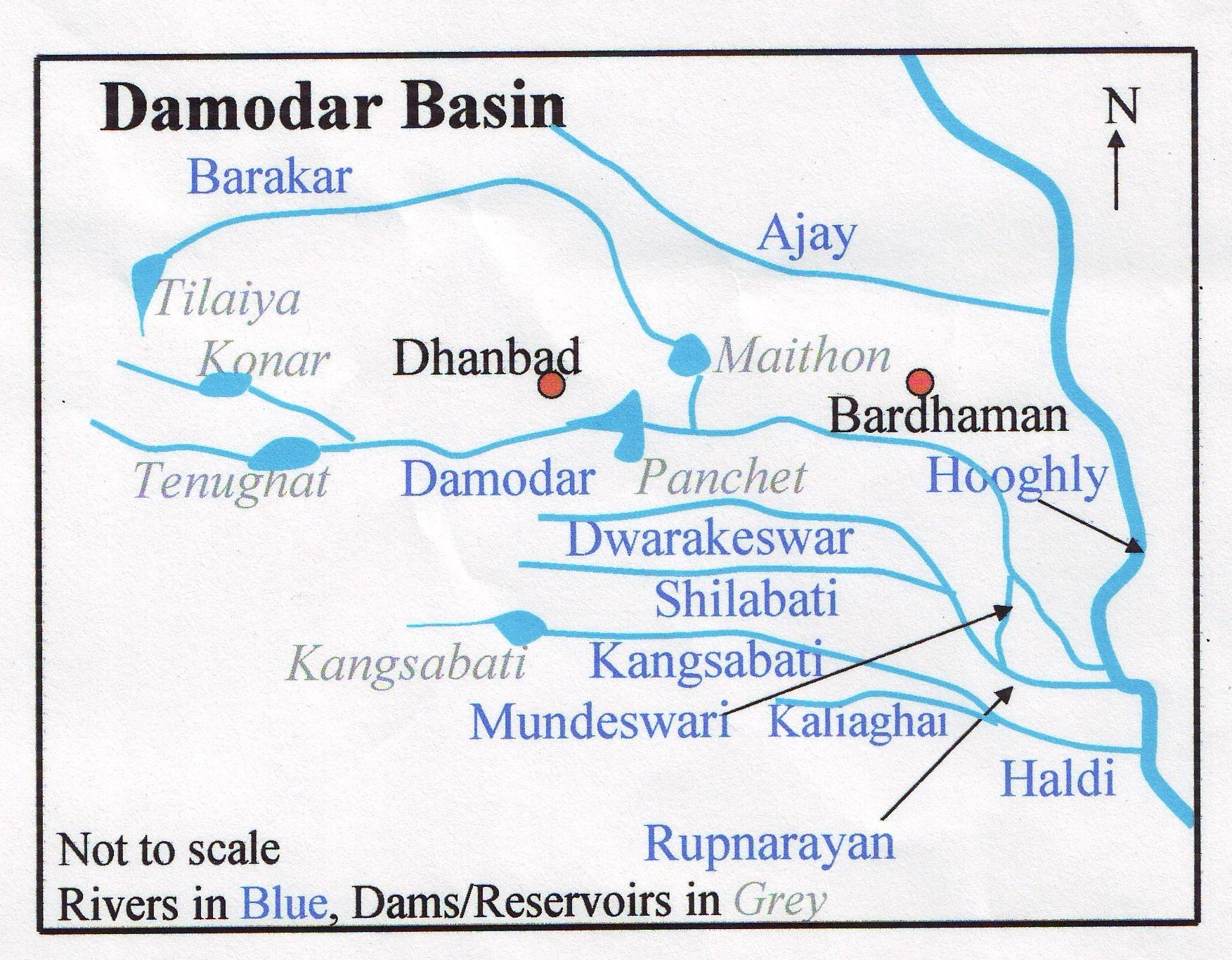
map_caption =The Barakar River ( _bn. বরাকর নদী) is the main tributary of
Damodar River in easternIndia . Originating near Padma inHazaribagh district ofJharkhand it flows for 225 km across the northern part of theChota Nagpur plateau , mostly in a west to east direction, before joining the Damodar near Dishergarh inBardhaman district ofWest Bengal . It has a catchment area of 6159 km². The main tributaries, Barsoti and Usri, flow in from the south and north respectively. Apart from the two main tributaries some fifteen medium/small streams join it. [ Chattopadhyay, Akkori, "Bardhaman Jelar Itihas O Lok Sanskriti" (History and Folk lore of Bardhaman District.), Bn icon, Vol I, p 26, Radical Impression. ISBN 81-85459-36-3 ]The Barakar skirts the northern portion of Parashanth Hill, (1350 m/4470 ft), the highest hill in the region, located in
Giridih district of Jharkhand and a centre ofJain pilgrimage.Fury of the river
The river flows in all fury during the rains in its upper reaches and has washed away two bridges constructed successively on the
Grand Trunk Road . The great stone bridge across the river near Barhi, in Hazaribagh district, built around 1848, was washed away in 1913, after a fall of convert|10|in|mm of rain in 24 hours. The narrow iron bridge, which was built to replace it, withstood the strains of troop movement during the Second World War, but gave way in 1946, with another great flood. [ Houlton, Sir John, "Bihar the Heart of India", 1949, p117, Orient Longmans Ltd. ] A new bridge built in the fifties has withstood the fury of the river.There is another bridge on the Grand Trunk Road, across the Barakar, connecting
Barakar , a small town bearing the same name inBardhaman district ofWest Bengal with Chirkunda in Jharkhand. With heavy traffic in the heart of the coal belt, the bridge built in the mid 19th century is in need of repairs. A new bridge has been built, to the north, on the bypass running from Kalipahari, before entering Asansol to Nirsa in Dhanbad district.The huge volume of monsoon water was carried down the valley and used to create havoc with floods in the lower Damodar basin. Annual rainfall over the basin varies between 765 and 1607 mm with an average of 1200 mm of which 80% occurs during the monsoon season from June to September.cite web
url =http://envfor.nic.in/divisions/cltech/Damodar/1.1.htm
title = Damodar Valley
accessdate = 2007-02-14
last =
first =
work =
publisher =Ministry of Environments and Forests] In order to harness the river (along with the Damodar), theDamodar Valley Corporation planned and implemented independent India’s first multipurpose river valley project.cite web
url = http://www.dvcindia.org
title = Damodar Valley Corporation
accessdate = 2007-02-14
last =
first =
work =
publisher =Damodar Valley Corporation] The first dam of the project was constructed across the Barakar at Tilayia.Dams and power stations
Tilayia
DVC’s first dam was across the Barakar at Tilayia, in
Hazaribagh district ofBihar , now inJharkhand . It was inaugurated on 21 February 1953. The dam is 366 meters long and is 30.18 meters high from the river bed level. Tilaiya hydel power station is located on the left bank of the river Barakar. The structure is entirely of reinforced concrete. It has two generating units of 2 MW each with a provision for a third future unit of the same capacity.Maithon
DVC’s second dam was across the Konar River, a tributary of the Damodar, in Hazaribagh district, and the third was across the Barakar at Maithon in
Dhanbad district of Bihar, now Jharkhand. The river forms the boundary betweenWest Bengal and Jharkhand in that area. The dam was inaugurated on 27 September 1957. The dam (both concrete and earthen) is 4860 meters long and the concrete dam is 43.89 meters high above the river bed level. The unique feature of Maithon is that the hydel power station is located underground in the left bank of the river (on the West Bengal side) and is the first of its kind in India. The Power Station has a total generating capacity of 60 MW with three units of 20 MW each. About 13 km downstream from Maithon, the Barakar joins the Damodar.Maithon Dam is 48 km from
Dhanbad and around 25 km fromAsansol . Other towns such asSalanpur ,Chittaranjan andKulti lie still nearer. It receives a steady and daily stream of tourists.In order to augment the meagre hydroelectric power generation DVC has gone in for both gas turbine and thermal power generation. While most of its facilities for such generation lie in the Damodar region, Maithon in the Barakar regions is a major focal point. Maithon Gas Turbine Station was commissioned at Maithon in 1989. The station has an installed capacity of 82.5 MW with three units each of 27.5 MW capacity.
The 2 X 500 MW Maithon Right Bank thermal power station is under implementation. It is a joint venture of Tata Power and DVC. A 2 X 500 MW greenfield thermal power station has been proposed for Koderma.cite pressrelease
url =http://www.tata.com/tata_power/releases/20050329.htm
title = Tata Power signs generation pact with DVC on Maithon project
accessdate = 2007-02-14
last =
first =
work =
publisher =Tata Power]Proposed dam at Balpahari
DVC is working on the proposal for a third dam across the Barakar at Balpahari in Jharkhand. Planned as part of its network of dams and barrages in the valley region, the Balpahari project was conceived with the objective of reducing siltation problems at Maithon, increasing the reach of canal irrigation and adding to hydro-electric generation capacity by 20 MW from the existing 144 MW.cite news
first = Pratim Ranjan
last = Bose
title = Damodar Valley to undertake dam project in Jharkhand
url = http://www.thehindubusinessline.com/2005/05/26/stories/2005052601121700.htm
format =
work =Business
publisher = The Hindu Business Line
date =26 May 2005
accessdate = 2007-02-14]oil conservation
After the construction of the four dams at Tilayia, Konar, Maithon and Panchet by DVC, it was observed that the rate of silt inflow into the reservoirs were much higher than what was anticipated earlier. It threatened the longevity of the reservoirs. The catchment area of these reservoirs spread over the undulating terrain of the Chota Nagpur plateau is seriously affected by soil erosion. Large volume of silt in the form of coarse and fine sediment is removed from the area by erosion under the impact of the water flow caused by torrential rain, which runs down the numerous stream channels during the monsoon. Thus the problem of reservoir siltation assumed great importance in the case of DVC. In order to prolong the life of the reservoirs, there was need for soil conservation and silt control. DVC set up a Soil Conservation Department at
Hazaribagh to tackle the twin problems of reservoir siltation and soil deterioration in 1949.cite web
url = http://www.dacnet.nic.in/SCTC%20Hazaribag/hazari_intro.htm
title = Soil Conservation
accessdate = 2007-02-14
last =
first =
work =
publisher =Damodar Valley Corporation]Fisheries
The reservoirs at Tilaiya and Maithon, provided scope for development of fisheries. Efforts were made to introduce carps once the water accumulated behind the dams but the results have not been commensurate with the efforts, largely due to the formidable presence of predatory catfish W. attu and other predators such as Notopterus chitala and Barilius bola at Tilaiya, and catfishes Wallago attu and Aorichthys aor, at Maithon. These predators take a heavy toll of the stocked carps Trash and uneconomic fishes form dense population at Tilaiya reservoir, competing with major carps for food. Composition of catch at both the places is: catla, mrigala, rohita and calbasu.cite web
url = http://www.fao.org/DOCREP/003/V5930E/V5930E15.htm
title = Fisheries
accessdate = 2007-02-14
last =
first =
work =
publisher =]References
ee also
Wikimedia Foundation. 2010.