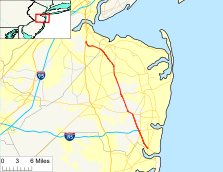
- New Jersey Route 34
-
Route 34
Route information Maintained by NJDOT Length: 26.79 mi[1] (43.11 km) Existed: 1927 – present Major junctions South end: 
 Route 35 / Route 70 in Wall Township
 G.S. Pkwy. in Wall Township

 I-195 / Route 138 in Wall Township
 Route 33 in Howell Township
 Route 18 in Colts Neck Township
 Route 79 in Matawan
North end:  US 9 in Old Bridge
Highway system New Jersey State Highway Routes
Interstate and US← Route 33Route 35 →Route 34 is a state highway in the central part of the U.S. state of New Jersey. The route runs 26.79 mi (43.11 km) from an intersection with Route 35 and Route 70 (the former Brielle Circle) in Wall Township, Monmouth County north to an intersection with U.S. Route 9 in Old Bridge Township, Middlesex County. The route is a four-lane divided highway between its southern terminus and the north end of the Route 33 concurrency in Howell Township; along this stretch, the route intersects the Garden State Parkway and Interstate 195/Route 138 within a short distance of each other. North of Route 33, Route 34 is an undivided two- to four-lane road that intersects Route 18 in Colts Neck Township and Route 79 in Matawan. Route 34 passes through mostly suburban areas along its route.
The route was legislated in 1927 to run from Route 35 (present Route 88) in Laurelton north to Route 4 (present Route 79) in Matawan. The current alignment of Route 34 north of Matawan was a part of Route 4 (and later U.S. Route 9) until it became a part of Route 4A following a realignment of U.S. Route 9 and Route 4. In 1953, Route 34 was extended north along Route 4A to end at U.S. Route 9 in Old Bridge Township. Meanwhile, the southern terminus was cut back to its current location with the route south of that point becoming a part of Route 70. Since 1953, the southern portion of the route was widened into a divided highway and the Brielle Circle was replaced.
Contents
Route description
 Route 34 northbound approaching the Garden State Parkway.
Route 34 begins at an intersection with Route 35 and Route 70 in Wall Township, Monmouth County at the former Brielle Circle, heading to the northwest on a six-lane undivided road with a 55 mph (89 km/h) speed limit.[1] A short distance past this intersection, the route becomes a four-lane divided highway that passes through commercial areas with some neighboring wooded residential areas. It interchanges with County Route 524 Spur (Atlantic Avenue) and passes more businesses and wooded areas before reaching the Allenwood Circle, where Route 34 intersects County Route 524 (Allaire Road).[1][2] Past the Allenwood Circle, the road continues northwest to a partial interchange with the Garden State Parkway. This interchange has access to the northbound Garden State Parkway from northbound Route 34, to the southbound Garden State Parkway from southbound Route 34, and to both directions of Route 34 from the southbound Garden State Parkway.[2] Immediately past this interchange, the road intersects County Route 30 before coming to a cloverleaf interchange with Interstate 195 and Route 138.[1] Route 34 provides the missing movements between the southbound Garden State Parkway and Interstate 195/Route 138. From here, the road passes through woodland before heading into commercial and industrial areas, where it passes by the Monmouth Executive Airport.[2] The route enters wooded residential and business areas where it intersects Belmar Boulevard and Megill Road, which are both distinct segments of County Route 18. Route 34 continues through wooded commercial areas before it intersects Route 33 and County Route 547 at the Collingwood Circle.[1][2]
At the traffic circle, Route 34 turns northwest to form a concurrency with Route 33 on a four-lane divided highway with a speed limit of 50 mph (80 km/h) that passes businesses, crossing into Howell Township.[1][2] The two routes eventually split, with Route 34 heading north on a 50 mph (80 km/h) two-lane undivided road.[1] It passes through wooded areas of Naval Weapons Station Earle and enters Colts Neck Township.[1][2] Upon leaving the grounds of Naval Weapons Station Earle, the route widens into a four-lane divided highway again and comes to a cloverleaf interchange with the Route 18 freeway.[1] Past this interchange, Route 34 becomes a 45 mph (72 km/h) two-lane undivided road that passes residences, commercial areas, and Delicious Orchards before crossing County Route 537 (Colts Neck Road/Eatontown Road). From here, the road heads through suburban residential and agricultural areas as a 50 mph (80 km/h) road, intersecting County Route 54 (Phalanx Road) before meeting County Route 4 (Conover Road).[1][2] Route 34 forms a brief concurrency with County Route 4 until the county route heads northeast on South Street.[1] The route continues into wooded residential areas, crossing into Holmdel Township, where it crosses County Route 520 (Newman Springs Road/Main Street).[1][2]
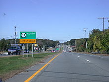
 Route 34 northbound at the Allenwood Circle.
Past this intersection, the road continues through areas of residences and farms before turning northwest into more residential surroundings and entering Marlboro Township. Here, the road heads through wooded residential and commercial areas, briefly becoming a four-lane road, before it crosses into Aberdeen Township. In Aberdeen, Route 34 becomes a 45 mph (72 km/h) road that heads into business areas as it crosses County Route 3 (Lloyd Road). The road passes more businesses as a 40 mph (64 km/h) three-lane road with a center left-turn lane, forming the border of Matawan to the west and Aberdeen Township to the east. At the crossing of an abandoned railroad line that is now the Henry Hudson Trail, the route entirely enters Matawan, continuing northwest through business areas as a 35 mph (56 km/h) four-lane road named Middlesex Street.[1][2] Here, Route 34 intersects County Route 516 (Broad Street) and Route 79 and County Route 516 Spur (Main Street).[1] Past these intersection, the road heads into residential areas, crossing over Lake Lefferts before continuing northwest through a mix of residences and businesses with a speed limit of 40 mph (64 km/h).[1][2]
Route 34 crosses into Old Bridge Township, Middlesex County, where it becomes a two-lane road with a 50 mph (80 km/h) speed limit, continuing through commercial areas. The route intersects County Route 689 (Amboy Avenue/Morristown Road), where it turns to the west and continues through areas of residences and businesses, with the speed limit dropping to 45 mph (72 km/h) at the County Route 687 (Cottrell Road) intersection.[1][2] At the intersection with County Route 699 (Old Mill Road), Route 34 turns to the north and intersects another segment of County Route 699 known as Spring Hill Road.[1] The road passes more residences and businesses before it ends at an intersection with U.S. Route 9.[2]
History
In the 1927 New Jersey state highway renumbering, Route 34 was legislated to run from an intersection with Route 35 (now Route 88 in Laurelton, Ocean County north to Route 4 (now Route 79) in Matawan, with the portion of current Route 34 north of that intersection legislated as part of Route 4.[3][4] By the 1940s, U.S. Route 9 was also designated along the present-day portion of Route 34 that was then a part of Route 4, this would later become Route 4A after U.S. Route 9 and Route 4 were moved to a new alignment between Freehold and Cheesequake.[5] In the 1953 New Jersey state highway renumbering, Route 34 was extended north along the alignment of Route 4A to end at U.S. Route 9 in Cheesequake while the southern terminus was cut back to the Brielle Circle intersection with Route 35 and Route 70, the latter having replaced Route 34 south of this point.[6] By 1969, Route 34 was widened into a divided highway as far north as Route 33.[7] The Brielle Circle at the southern terminus of the route was converted into at-grade intersections with traffic lights in 2001.[8]
Major intersections
County Location Mile[1] Destinations Notes Monmouth Wall Township 0.00 Route 35 / Route 70 westSouthern terminus, former Brielle Circle 1.97 
 CR 524 Spur (Atlantic Avenue)
Interchange 2.63 CR 524 (Allaire Road)Allenwood Circle 3.52-3.61 G.S. Pkwy.GSP exit 98 4.13 I-195 west / Route 138 eastI-195 exit 35 7.72  Route 33 east / CR 547 (Asbury Avenue)
Collingwood Circle, south end of NJ 33 overlap Howell Township 8.76 Route 33 westNorth end of NJ 33 overlap Colts Neck Township 12.27 Route 18NJ 18 exit 19 13.21  CR 537 (Colts Neck Road/Eatontown Road)
Holmdel Township 17.40  CR 520 (Newman Springs Road/Main Street)
Matawan 22.34  CR 516 (Broad Street)
22.42 
Route 79 south / CR 516 Spur north (Main Street)Middlesex Old Bridge Township 26.79 US 9Northern Terminus 1.000 mi = 1.609 km; 1.000 km = 0.621 mi See also
 U.S. Roads portal
 New Jersey portal
References
- ^ a b c d e f g h i j k l m n o p q r "Route 34 straight line diagram" (PDF). New Jersey Department of Transportation. http://www.state.nj.us/transportation/refdata/sldiag/00000034__-.pdf. Retrieved 2009-07-07.
- ^ a b c d e f g h i j k l Google, Inc. Google Maps – overview of New Jersey Route 34 (Map). Cartography by Google, Inc. http://maps.google.com/maps?f=d&source=s_d&saddr=RT-35+%26+RT-34,+Manasquan,+Monmouth,+New+Jersey+08736&daddr=route+34+and+old+road+old+bridge,+nj&geocode=FV0fZAIdt7yV-w%3B&hl=en&mra=ls&sll=40.439892,-74.297447&sspn=0.014437,0.027509&ie=UTF8&t=h&z=10. Retrieved 2009-07-07.
- ^ State of New Jersey, Laws of 1927, Chapter 319.
- ^ Williams, Jimmy and Sharon. "1927 New Jersey Road Map". 1920s New Jersey Highways. http://www.jimmyandsharonwilliams.com/njroads/1920s/images/1927_routes.gif. Retrieved 2008-10-08.
- ^ Mid-West Map Co. (1941). Map of Pennsylvania and New Jersey (Map). Cartography by H.M. Gousha. http://www.mapsofpa.com/roadcart/1941_1467m.jpg. Retrieved 2009-03-29.
- ^ 1953 renumbering. New Jersey Department of Highways. http://en.wikisource.org/wiki/1953_New_Jersey_state_highway_renumbering. Retrieved July 31, 2009
- ^ Chevron Oil Company (1969). Map of New Jersey (Map). Cartography by H.M. Gousha.
- ^ "DiFrancesco and Weinstein Open Newly Reconfigured Interchange". New Jersey Department of Transportation. http://www.state.nj.us/transportation/about/press/2001/051701a.shtm. Retrieved 2008-12-21.
External links
Categories:- Transportation in Middlesex County, New Jersey
- Transportation in Monmouth County, New Jersey
- State highways in New Jersey


Wikimedia Foundation. 2010.