- Mirsharai Upazila
-
'click' Mirsarai Official Web Site www.mirsarai.info
Mirsharai
মীরসরাই— Upazila — Location in Bangladesh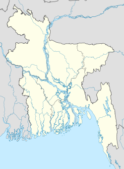
 Mirsharai
Coordinates: 22°46.3′N 91°34.5′E / 22.7717°N 91.575°ECoordinates: 22°46.3′N 91°34.5′E / 22.7717°N 91.575°E Country  Bangladesh
Division Chittagong Division District Chittagong District Area - Total 482.88 km2 (186.4 sq mi) Population (1991) - Total 325,712 - Density 675/km2 (1,748.2/sq mi) Time zone BST (UTC+6) 4320 4320 Website Official Map of Mirsharai Mirsharai Upazila (chittagong district) with an area of 482.88 km2, is bounded by Tripura State of India, chhagalnaiya and feni sadar upazilas on the north, sitakunda and sandwip upazilas on the south, fatikchhari upazila on the east, sonagazi and companiganj (Noakhali) upazilas on the west. Approximately 60 km from the chittagong city. Main river is feni; Sandwip Channel is notable; canal 30, most noted of which are Isakhali, Mahamaya, Domkhali, Hinguli,Moliaish, Koila Govania and Mayani Khal. The hills range on the northern and eastern side of this upazila along the bank of the feni river extended up to Chittagong and the chittagong hill tracts.
Mirsharai (Town) consists of two mouzas. It has an area of 10.12 km2. The town has a population of 10856; male 51.49% and female 48.51%; population density per km² 1073. Literacy rate among the town people is 32%. The town has two dakbungalows.
Administration Mirsharai thana was turned into an upazila in 1983. The upazila consists of 16 union parishads, 100 mouzas and 207 villages.
Archaeological heritage and relics Hinguli Court Parr (embankment) built by Arakani Moghs, Valukia Dighi, Chuti Khan Mosque, Poragol Khan Dighi, Nai Duari (nine-door) Mosque, Daulat Bibi Mosque and Mahania Mosque.
Historical events Fakruddin Mobarak Shah established the Muslim rule in this region in 1340. During the region of Hossain Shah and Nasrat Shah (Sultans of the Gaur), Paragal Khan and Chhuti Khan were the rulers of this region. Later on Nizam Shah, brother of Sher Shah (emperor of Delhi), became its ruler. Nizampur Pargana was named after him and the total area of Mirsharai came under the jurisdiction of Nizampur Pargana. From the beginning of 16th century this area was one of the centres for practising Bangla literature; most noted poets and writers include Sayed Sultan, Kabindra Poromessor, Srikor Nandi, Daulat Uzir Bahram Khan. Most of the time from 1580 to 1666, this region was under the control of the Arakans. The place at Mirsharai Thana, where Bujurgo Umed Khan (son of Subeder Syesta Khan) landed after crossing the Feni River, was named as Bujurgo Umed Nagar. After the conquest of Chittagong, this region came permanently under the Mughals rule. Towards the end of the British rule, Durgapur and Karerhat of Mirsharai upazila were the main centres of the revolutionaries of Chittagong. During the War of Liberation many direct encounters between the Pak army and the freedom fighters were held at Shuvopur Bridge, Higuli Bridge, Auchi Miah Bridge and Mostannagar.
Marks of the War of Liberation Mass grave 1, memorial monument 1, mass killing site 2.
Religious institutions Mosque 640, tomb 50, temple 128 and Buddhist temple 9, most noted of which are Chhuti Khan Mosque (16th century), Daulat Bibi Mosque (16th century), Mahadia Mosque (1780),Dhan Meah jamia mosk(1813), Nai Duari Mosque (18th century), Hamidullah Khan Mosque (19th century), Mazars of Shah Zayed (R) (806 AH), Awal Kazi Moakkel (R), Hazrat Shah Badal (R), Hazrat Chinki Mostan (R), Hazrat Mia Noor Ali Shah (R), Sufi Noor Mohammad Nizampuri (R) and Hazrat Mir Gaffar Khan; Jagannath Mandir (Abu Torab Bazar), Kali Mandir (Karerhat), Hazisharai Mandir and Newanpur Mandir.
Population 325712; male 49. 97%, female 50.03%; Muslim 84.9%, Hindu 13.97% and others 1.13%.
Literacy and educational institutions Average literacy 37.2%; male 45.1% and female 29.3%. Educational institutions: college 4, high school 46, junior school 4, madrasa 38, government primary school 145, non-government primary school 55, madrasa 1, satellite school 8 and kindergarten school 8.
Newspapers and periodicals Mirsarai Songbad,The MONTHLY SOMOY,Mashik Mirsharai; irregular: Mirsharai Chitra, Mirsharai Kantho, Alokito Campus; extinct: Mirsharai Barta, Mirsharai Darpan,.
Cultural organisations Press club 1, club 63, public library 1, theatre group 2, playground 70, stadium 1, music school 3.
Main occupations Agriculture 34.06%, forestry 2.23%, agricultural labourer 15.86%, wage labourer 3.39%, commerce 10.8%, service 16.89%, fishing 1.32%, transport 2.37% and others 11.26%.
Land use Total cultivable land 22,896.40 hectares, fallow land 147713 hectares; single crop 38.91%, double crop 42.46% and treble crop land 18.63%. Cultivable land under irrigation 6,917.85 hectare.
Value of land The market value of the land of the first grade is approximately Tk 9000 per 0.01 hectare.
Main crops Paddy, potato, aubergine, bean, tomato, pumpkin and radish.
Extinct or nearly extinct crops Sugarcane, jute, arahar, mustard, pulse, linseed, kalai sesame and peanut.
Main fruits Mango, black berry, jackfruit, banana, papaya and litchi.
Fisheries, dairies, poultries Fishery 100, poultry 131 and hatchery (fish) 1.
Communication facilities Roads: pucca 193 km, semi pucca 119 km and mud road 1500 km; railways 16 km; waterways 11-nautical-mile (20 km).
Traditional transport Palanquin, Shampan boat and bullock cart. These means of transport are either extinct or nearly extinct.
Manufactories Carpet industry, pipe mill, ice factory, etc.
Cottage industries Weaving 903, goldsmith 110, blacksmith 100, potteries 100, bidi 4, tailoring 250, wood work 150, bamboo work 200 and sanitary 20.
Hats, bazars and fairs Hats and bazars are 30, most noted of which are Mohajan Hat, Abu Torab Bazar, Kamar Ali Bazar, Boro Daroga Hat, Karer Hat, Baroiar Hat, Shantir Hat, Jorarganj,sadurbazar, Mithachara, Fakir Hat, Abur Hat and Bamonsundar Daroga Hat, Golker Hat; fairs 5.
Main exports Bamboo, wood, fish, paddy, potato, banana and vegetables.
NGO activities Operationally important NGOs are proshika, brac, asa, Sheba, grameen bank, icddr, b, CARE, Hunger Project, DORP, Bais Opka, IPSA, Fatema Palli, Swasthya Shikkha Centre and Eva.
Health centres Upazila health complex 1, family planning centre 16, sub health centre Mirsharai (Bengali: মীরসরাই) is an Upazila of Chittagong District in the Division of Chittagong, Bangladesh.
Contents
Geography
Mirsharai is located at 22°46′20″N 91°34′30″E / 22.7722°N 91.5750°E . It has 55771 units of house hold and total area 482.88 km².
Demographics
As of the 1991 Bangladesh census, Mirsharai has a population of 325712. Males constitute are 49.97% of the population, and females 50.03%. This Upazila's eighteen up population is 160496. Mirsharai has an average literacy rate of 37.2% (7+ years), and the national average of 32.4% literate.[1]
Administrative
Mirsharai has 16 Unions/Wards, 116 Mauzas/Mahallas, and 207 villages.
See also
References
- ^ "Population Census Wing, BBS.". Archived from the original on 2005-03-27. http://web.archive.org/web/20050327072826/http://www.bangladeshgov.org/mop/ndb/arpc91_v1/tables04.htm. Retrieved November 10, 2006.
 Upazilas of the Chittagong DivisionCapital: Chittagong
Bandarban District 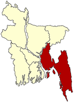
Brahmanbaria District Chandpur District Chittagong District Anwara · Banshkhali · Boalkhali · Chandanaish · Fatikchhari · Hathazari · Lohagara · Mirsharai · Patiya · Rangunia · Raozan · Sandwhip · Satkania · SitakundaComilla District Barura · Brahmanpura · Burichong · Chandina · Chauddagram · Daudkandi · Debidewer · Homna · Comilla Sadar Adarsha · Comilla Sadar South · Laksam · Muradnagar · Nangalkot · Titas · Meghna · MonoharganjCox's Bazar District Feni District Khagrachari District Dighinala · Khagrachhari · Lakshmichhari · Mahalchhari · Manikchhari · Matiranga · Panchhari · RamgarhLakshmipur District Noakhali District Begumganj · Chatkhil · Companiganj · Hatiya · Kabir Hat · Noakhali · Senbagh · Sonaimuri · SubarnacharRangamati District Bagaichhari · Barkal · Kawkhali · Belaichhari · Kaptai · Juraichhari · Langadu · Mannerchar · Rajasthali · RangamatiUpazilas and Thanas in Chittagong Anwara Upazila · Banshkhali Upazila · Boalkhali Upazila · Chandanaish Upazila · Fatikchhari Upazila · Hathazari Upazila · Lohagara Upazila · Mirsharai Upazila · Patiya Upazila · Rangunia Upazila · Raozan Upazila · Sandwip Upazila · Satkania Upazila · Sitakunda Upazila · Pahartali Thana · Panchlaish Thana · Chittagong Kotwali Thana · Chandgaon Thana · Bandar Thana · Double Mooring Thana · Karnafuly Thana · Bakoliya Thana · Baijed Thana · Paharthali Thana · Bhujpur ThanaCategories:- Upazilas of Chittagong District


Wikimedia Foundation. 2010.