- Sierra de las Minas
Geobox Mountain Range
name = Sierra de las Minas
native_name =
other_name =
other_name1 =
image_size =
image_caption =
etymology =
country = Guatemala
country1 =
state =
state1 =
region =Alta Verapaz ,Baja Verapaz ,El Progreso , Zacapa, Izabal
region1 =
district =
district1 =
city =
city1 =
unit =
unit1 =
part_count =
part =
part1 =
border =
border1 =
geology =
geology1 =
period =
period1 =
orogeny =
orogeny1 =
area =
length_imperial =
length_orientation =
length_round =
width_imperial =
width_orientation =
width_round =
highest =Cerro Raxón
highest location =
highest_country = Guatemala
highest_state =
highest_region = Alta Verapaz
highest_district =
highest_elevation = 3015
highest_lat_d = 15.163063
highest_lat_m = -89.851255
highest_lat_s =
highest_lat_NS =
highest_long_d =
highest_long_m =
highest_long_s =
highest_long_WE =
lowest =
lowest_location =
lowest_country =
lowest_state =
lowest_region =
lowest_district =
lowest_elevation_imperial =
lowest_lat_d =
lowest_lat_m =
lowest_lat_s =
lowest_lat_NS =
lowest_long_d =
lowest_long_m =
lowest_long_s =
lowest_long_WE =
woods =
free_name =
free_value =
map_size =
map_caption =
map_first =Sierra de las Minas is a mountain range in eastern
Guatemala , extending 130 km west of theLake Izabal . It is 15-30 km wide and bordered by the valleys of the rivers Polochic in the north and the Motagua in the south. Its western border is marked by the Chuacús mountain range. The highest peak isCerro Raxón at 3,015 m.The Sierra's rich deposits of jade andmarble have been mined throughout the past centuries. These small scale mining activities also explain the name of the mountain range.The range has several different
habitat s, including Mesamerica's largestcloud forest s, and is home to a great variety of wildlife. Part of the Sierra de las Minas was declared abiosphere reserve .Biosphere reserve
Geobox|Protected Area
name = Sierra de las Minas biosphere reserve
native_name =
other_name =
category = VI
etymology =
official_name =
motto =
nickname =
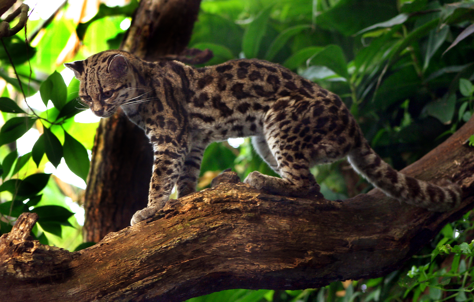
image_caption = The reserve has a significantMargay population
symbol =
country =Guatemala
state =
region =Alta Verapaz ,Baja Verapaz ,El Progreso , Zacapa, Izabal
district =
municipality =
city =
landmark =
river =
location =
elevation =
prominence =
lat_d = | lat_m = | lat_s = | lat_NS =
long_d = | long_m = | long_s = | long_EW =
highest =Cerro Raxón
highest_location = | highest_region = | highest_country =
highest_elevation = 3015
highest_lat_d = | highest_lat_m = | highest_lat_s = | highest_lat_NS =
highest_long_d = | highest_long_m = | highest_long_s = | highest_long_EW =
lowest =
lowest_location = | lowest_region = | lowest_country =
lowest_elevation = 150
lowest_lat_d = | lowest_lat_m = | lowest_lat_s = | lowest_lat_NS =
lowest_long_d = | lowest_long_m = | lowest_long_s = | lowest_long_EW =
length = | length_orientation =
width = | width_orientation =
area = 2366
geology =
biome = - Subtropical thorn forest - Premontane dry subtropical forest - Premontane tropical wet forest - Lower montane subtropical moist forest -Cloud forest
plant =
animal =
established =
date = 1990
management = CONAP, Defensores de la Naturaleza
management_location = | management_region = | management_country =
management_elevation =
management_lat_d = | management_lat_m = | management_lat_s = | management_lat_NS =
management_long_d = | management_long_m = | management_long_s = | management_long_EW =
owner =
leader =
public =
visitation = | visitation_date =
access =
whs_name =
whs_year =
whs_number =
whs_region =
whs_criteria =
iucn_category = VI
free = | free_type =
map_caption =
map_background =
map_locator =
map_locator_x =
map_locator_y =
website = [http://www.defensores.org.gt Defensores de la Naturaleza]
footnotes =In 1990, part of the Sierra de las Minas (236,626 hectares, including buffer zones and transition areas) was designated a biosphere reserve. [cite web | url=http://www.conap.gob.gt:7778/conap/areas-protegidas/sigap/listado-areas-protegidas/listado-areas-protegidas | publisher= | title=Listado áreas protegidas | author=CONAP | access=2008 | format= |language=Spanish]Habitats and land cover types
Due to its size and great variaty in elevation and precipitation, the range has many different habitats and land cover types, including: [cite web | url=http://www.unesco.org/mabdb/br/brdir/directory/biores.asp?code=GUA+02&mode=all | publisher= | title=MAB Biospheres Reserves Directory: Guatemala - Sierra de las Minas| author=UNESCO | access=2008 | format= |language=]
* Subtropical thorn forest, also known asMotagua Valley thornscrub , withCactus species.,Guayacum species,Acacia farnesiana andBucida macrostachys .
* Premontane dry subtropical forest withEncyclia diota , Ceiba aesculifolia and Leucaena guatemalensis.
* Premontane tropical wet forest includingOrbignya cohune , Terminalia amazonia,Pinus caribaea andManilkara zapota .
* Lower montane subtropical moist forest withPinus oocarpa ,Quercus species, Alnus jorulensis andEncyclia selligera .
*Cloud forest includingAlfaroa costaricensis ,Brunellia mexicana ,Gunnera species,Magnolia guatemalensis etc.;
*Agroecosystem s withcoffee ,rice ,maize , etc.
* Pasture land withTillandsia s distributionFauna
The reserve has 885 species, about 70% of all species found in Guatemala and Belize, including threatenend birds like the
quetzal (Pharomachrus mocinno ),harpy eagle (Harpia harpyja ) and thehorned guan (Oreophasis derbianus ).Felines with a significant presence are the
jaguar (Panthera onca ),puma (Felis concolor ), onza (Herpailorus yagouaroundi),ocelot (Leopardus pardalis ) andmargay (Leopardus wiedii ).Other mammals in the reserve include the
red brocket (Mazama americana ), thehowler monkey (Alouatta palliata ) andBaird's tapir (Tapirus bairdii ). [cite web | url=http://www.iucnredlist.org/search/search.php?freetext=&modifier=phrase&criteria=wholedb&taxa_species=1&redlistCategory%5B0%5D=EN&country%5B0%5D=GT&cty_default=1&aquatic%5B0%5D=all&aqu_default=1®ions%5B0%5D=5®_default=1&habitats%5B0%5D=all&threats%5B0%5D=all&redlistAssessyear%5B0%5D=all&growths%5B0%5D=all&extendedResults=0&terrestrial=0&marine=0&freshwater=0&sortorder%5B0%5D=spcscientificname&sortorder%5B1%5D=genname&sortorder%5B2%5D=spcname&sortorder%5B3%5D=spcauthor&sortorder%5B4%5D=spcinfrarank&sortorder%5B5%5D=spcinfraepithet&sortorder%5B6%5D=spcinfrarankauthor&sortorder%5B7%5D=spcstockname&sortorder%5B8%5D=comname_comp&sortorder%5B9%5D=rlcabb&sortorder%5B10%5D=rlscriteria&sortorder%5B11%5D=poptrend_code&sortorder%5B12%5D=rlcatcrit2001&sortorder%5B13%5D=rlscaveat&sortorder%5B14%5D=rlspetition&sortorder%5B15%5D=spcrecid&sortorder%5B16%5D=kingname&newsort=&debug=0&kingname=&phyname=&claname=&ordname=&famname=&genname=&spcname=&taxa_subspc=0&taxa_stock=0&cty_intro=0&cty_vagrant=0&cty_uncert=0&aqu_intro=0&aqu_vagrant=0&aqu_uncert=0®_intro=0®_vagrant=0®_uncert=0&spc_petition=0&spc_caveat=0&offset=0| publisher= | title=IUCN - Red List of Threatened Species| author=IUCN | access=2008 | format= |language=]References
External links
* [http://www.defensores.org.gt Fundación Defensores de la Naturaleza]
* [http://www.nmnh.si.edu/botany/projects/cpd/ma/ma14.htm Description of Sierra de las Minas biosphere reserve]
* [http://www.unesco.org/mabdb/br/brdir/directory/biores.asp?code=GUA+02&mode=all UNESCO data on the Sierra de las Minas biosphere reserve]
* [http://www.parkswatch.org/parkprofile.php?l=eng&country=gua&park=smbr Parkswatch]
Wikimedia Foundation. 2010.