- Dwarakeswar River
-
Dwarakeswar River Dhalkisor River River Country India State West Bengal Tributaries - left Gandheswari River, Kukhra River, Birai River - right Shilabati River City Bankura Source Tilboni Hill 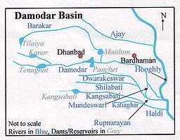
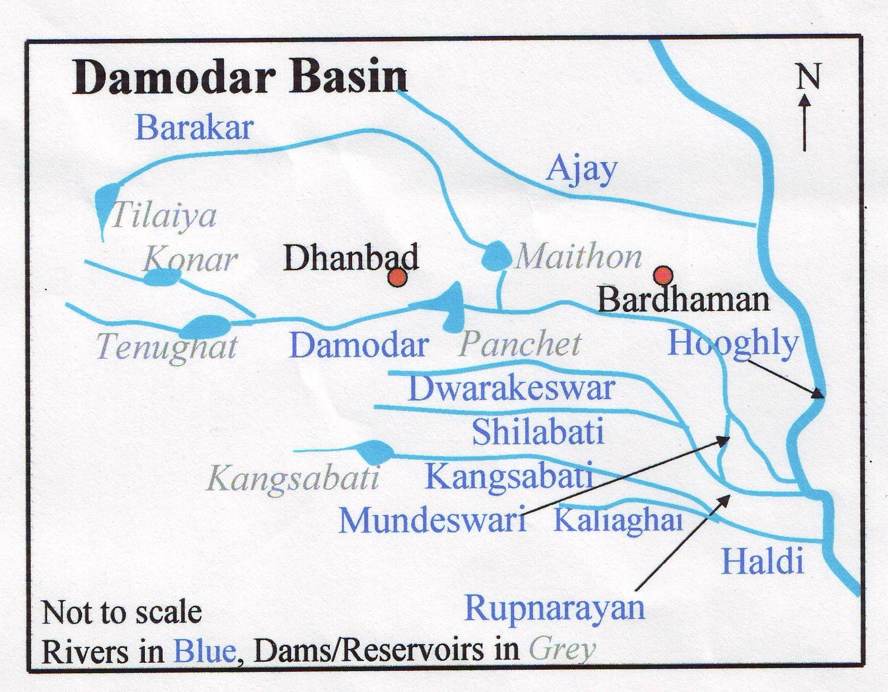
Dwarakeswar River (Bengali: দ্বারকেশ্বর নদ) (also known as Dhalkisor) is a major river in the western part of West Bengal.
Contents
Course
It originates from Tilboni hill in Purulia district and enters Bankura district near Chhatna. It cuts across the district flowing past the district head quarters and enters the south-eastern tip of Bardhaman District. It then passes through Hooghly District [1] The Silai joins it near Ghatal and the two together is known as Rupnarayan River, which flows into the Hooghly River near Gadiara in Howrah District.
Projects
There is a proposal for the construction of a dam across the Dwarakeswar. The preliminary project report on Dwarakeswar Gandheswari Reservoir was received in Central Water Commission in January, 2004 for which ‘in- principle’ consent of Central Water Commission for preparation of detailed Project Report has been conveyed to the State Government in March, 2004.[2]
References
- ^ Chattopadhyay, Akkori, Bardhaman Jelar Itihas O Lok Sanskriti (History and Folk lore of Bardhaman District.), (Bengali), Vol I, pp 33-34, Radical Impression. ISBN 81-85459-36-3
- ^ Yadav, Jai Prakash Narayan. "Lok Sabha Unstarred Question No. 1670 to be answered on 2004-7-19". Irrigation Schemes. Ministry of Water Resources. http://164.100.24.208/lsq14/quest.asp?qref=1823. Retrieved 2007-02-19.
See also
Rivers in and around Bengal Southeast Bangladesh Assam / Meghalaya /
TripuraBarak · Brahmaputra · Feni · Kangsha · Kushiyara · Manu · Meghna · Muhuri · Someshwari · Surma · Surma-Meghna · Titas / Haora · Gumti · KhowaiNorthern Bangladesh
North BengalAtrai · Balason · Bangali · Baral · Dharla · Dhepa · Gumani · Jaldhaka · Karatoya · Khong Khola · Mahananda · Mechi · Punarbhaba · Raidak or Wong Chhu · Rangeet · Tangon · Teesta · Torsa/Machu/Amo ChhuCentral Bangladesh Bangshi · Buriganga · Dhaleshwari · Gorai-Madhumati · Jamuna · Louhajang · Padma · Shitalakhya · TuragChotanagpur Ajay · Bakreshwar · Bansloi · Barakar · Brahmani · Damodar · Dwarka · Dwarakeswar · Gandheswari · Haldi · Hinglo · Kangsabati · Keleghai · Kopai · Kosai · Kunur · Mayurakshi · Mundeswari · Rasulpur · Rupnarayan · Sali · Shilabati · SubarnarekhaSouth Bengal
Ganges DeltaAdi Ganga · Baleshwar · Bidyadhari · Bura Gauranga · Churni · Gosaba · Hariabhanga · Hooghly · Ichamati · Jalangi · Kalindi · Matla · Muri Ganga · Pasur · Piyali · Raimangal · Saptamukhi · Saraswati · ThakuranRelated topics Beel · Country boats in Bangladesh · Chalan Beel · Ganges · Haor · Haors in Bangladesh · List of rivers of Bangladesh · of India · Waters of South Asia · Damodar Valley CorporationHydrology of surrounding areas Orissa • Jharkhand • Bihar • Nepal • Sikkim • Bhutan • North-east IndiaCoordinates: 23°08′21″N 87°17′11″E / 23.139097°N 87.286377°E
Categories:- Rivers of West Bengal
Wikimedia Foundation. 2010.