- Dumbarton Bridge (California)
-
Dumbarton Bridge 
The Dumbarton Bridge and its adjacent powerline towersCarries 6 lanes of  SR 84, bike/pedestrian
Crosses San Francisco Bay Locale Menlo Park, California and Fremont, California Total length 2,621.28 meters (8,600 ft), 1.63 miles Longest span 103.63 meters (340 ft) Clearance below 25.91 meters (85 ft) (main span) Opened October 1982 Toll Cars (westbound only)
$5.00 (cash or FasTrak), $2.50 (carpools during peak hours, FasTrak only)Daily traffic 81,000 Dumbarton Bridge crosses the Southern portion of San Francisco Bay 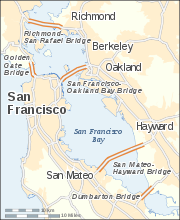
Coordinates 37°30′25″N 122°07′01″W / 37.5069°N 122.1169°WCoordinates: 37°30′25″N 122°07′01″W / 37.5069°N 122.1169°W The Dumbarton Bridge is the southernmost of the highway bridges that span the San Francisco Bay in California. Carrying over 81,000 vehicles daily, it is also the shortest bridge across San Francisco Bay at 1.63 miles (8,600 feet / 2,622 m). Its eastern terminus is in Fremont, near Newark in the San Francisco Bay National Wildlife Refuge, and its western terminus is in Menlo Park. The bridge has three lanes in each direction, and features a separated bike/pedestrian lane on its south-facing side. Like the San Mateo Bridge to the north, power lines parallel the bridge across the bay.
Tolls are collected in the westbound direction at the toll plaza, which is located on the eastern side of the bay; the toll is $5 as of 7/1/10.[1] There are six toll lanes at the plaza; the leftmost two are dedicated FasTrak lanes. An additional carpool lane to the left of these can be used only for half off by vehicles using FasTrak during weekday morning and afternoon commute hours by vehicles carrying two or more persons, motorcycles, or hybrid vehicles with a permit decal.
Contents
Environmental factors
 California clapper rail is a known resident of the western terminus area. Photo credit Don Roberson
When the current bridge was planned in the 1970s, Caltrans conducted extensive environmental research on the aquatic and terrestrial environment. Principal concerns of the public were air pollution and noise pollution impacts, particularly in some residential areas of Menlo Park and East Palo Alto. Studies were conducted to produce contour maps of projected sound levels and carbon monoxide concentrations throughout the western approaches, for each alternative connection scheme.[2]
The local area around the bridge is an important ecological area, hosting many species of birds, fish and mammals. The endangered species California clapper rail is known to be present in the western bridge terminus area.
Near the bridge on the Peninsula are Menlo Park's Bayfront Park, East Palo Alto's Ravenswood Open Space Preserve, and Palo Alto's Baylands Nature Preserve. An accessible portion of the San Francisco Bay National Wildlife Refuge lies immediately north of the western bridge terminus, where the Ravenswood trail runs.[3]
On both sides of the eastern terminus of the bridge are large salt ponds and levee trails belonging to the Don Edwards San Francisco Bay National Wildlife Refuge. The headquarters and visitor center for the refuge is on a hill south of the bridge approach. North of the eastern bridge terminus is Coyote Hills Regional Park, with its network of trails running over tall hills. North of that is the Alameda Creek Regional Trail, running from the Bay to Niles Canyon. East of Coyote Hills is Ardenwood Historic Farm, a restored working farm that preserves and displays turn-of-the-century farming methods
History and engineering features
 The original vertical-lift span of the Dumbarton Bridge, shown in 1984 shortly before it was demolished.
The bridge never was officially named, but the common use name comes from Dumbarton Point, which dates to 1876 when it was named for Dumbarton in Scotland. Built originally to provide a shortcut for traffic originating in San Mateo and Santa Clara Counties, the bridge served industrial and residential areas on both sides. The earlier bridge, opened on January 17, 1927, was the first vehicular bridge to cross San Francisco Bay. Portions of this old drawbridge remain as fishing piers. The original bridge was built with private capital and then purchased by the State for $2.5 million in 1951.
Its age and the limitations of a two-lane undivided roadway and lift-span made it necessary for a replacement bridge to be constructed to the north. This current bridge, a six-lane, high-level structure, was opened to traffic in October 1982. The cost of the complete replacement project was $200 million. The current bridge includes a two-way bicycle and separate pedestrian path on the south-facing side. A 340 ft (104 m) center span provides 85 ft (26 m) of vertical clearance for shipping. The approach spans on both sides of the Bay are of pre-stressed lightweight concrete girders supporting a lightweight concrete deck. The center spans are twin steel trapezoidal girders which also support a lightweight concrete deck. The center span of the original bridge was demolished in a controlled explosion in September 1984.
 A view from the air, above Palo Alto, looking towards Fremont
Connections to the western system
The bridge is part of State Route 84, and is directly connected to Interstate 880 by a freeway segment north of the Fremont end. There is no freeway connection between U.S. 101 and the southwest end of the Dumbarton Bridge. Motorists must traverse one of three at-grade routes to connect from the Bayshore Freeway to the bridge. These are (from northwest to southeast):
- the Bayfront Expressway, a limited-access road linking to U.S. 101 at Marsh Road, Atherton (the official routing of SR 84)
- Willow Road (SR 114), an approximately one-mile expressway through east Menlo Park to U.S. 101
- University Avenue (SR 109), an arterial road and the main commercial street of East Palo Alto.
Access to I-280 may be gained by Woodside Road (as signed) or there are other ways corresponding to the above; there is no freeway connection other than using CA 92 or CA 85 instead.
Although the present situation has resulted in severe traffic problems on the bridge itself and in Menlo Park and East Palo Alto, Caltrans has been unable to upgrade the relevant portion of Highway 84 to freeway standards for several decades, due to opposition from the cities of Menlo Park, Atherton and Palo Alto. Freeway opponents fear that upgrading Highway 84 will encourage more people to live in Alameda County (where housing is more affordable) and commute to jobs in the mid-Peninsula area (where businesses wish to be located in order to be close to Silicon Valley), thus increasing traffic in their neighborhoods to the south and west of U.S. 101.
Bus service across the bridge is provided by the Dumbarton Express, run by a consortium of local transit agencies (SamTrans, AC Transit, VTA and others) which connects to BART at Union City and Caltrain at Palo Alto and California Avenue. AC Transit also runs the Transbay buses U (Fremont BART and Amtrak to Stanford) and DA (Ardenwood to Oracle and Sun headquarters) across the bridge.
Dumbarton Rail Bridge
 Dumbarton Rail Bridge 2007 (from kayak)
Just to the south of the car bridge lies the Dumbarton Rail Bridge. Built in 1910, the rail bridge has been unused since 1982 and its western approach collapsed in a fire in 1998.[4] When in use, boaters would signal the bridge operator who would start a diesel engine and rotate the bridge to the open position on a large gear. The bridge is now left in the open position as shown. There are plans for a new rail bridge and rehabilitation of the rail line to serve a commuter rail service to connect Union City, Fremont, and Newark to various Peninsula destinations.[5] A successful March 2004 regional transportation ballot measure included funding to rehabilitate the rail bridge for the commuter rail service, but in October 2008 the Metropolitan Transportation Commission transferred $91 million from this project to the BART Warm Springs Extension Project in Fremont.[6]
Between the Dumbarton Bridge and the Dumbarton Rail Bridge is the Bay crossing of the Hetch Hetchy Aqueduct. The aqueduct rises above ground in Newark at the east side of the Bay, falls below the water's surface at a pump station in Fremont, re-emerges in the middle of the Bay and then continues above water until it reaches the west side of the Bay at Menlo Park.[7]
References
- ^ "MTC - News". Mtc.ca.gov. http://www.mtc.ca.gov/news/info/toll_increase.htm. Retrieved 2011-08-21.
- ^ C.M. Hogan, Leda Patmore, Harry Seidman et al., Air Quality and Acoustics Analysis for the Dumbarton Bridge Replacement Project, ESL Inc., prepared for the Bay Area Civision of Toll Crossings (1973)
- ^ San Francisco Bay Shoreline Guide, by California State Coastal Conservancy, University of California Press (1995) ISBN 0-520-08878-6
- ^ "Palo Alto Online Jan 7 1998 Story: "FIREFIGHTERS: Dumbarton rail bridge destroyed"". Paloaltoonline.com. 1998-01-07. http://www.paloaltoonline.com/weekly/morgue/news/1998_Jan_7.FIRE.html. Retrieved 2011-08-21.
- ^ "Dumbarton Rail Corridor". SMCTA. 2011-05-24. http://www.smcta.com/Dumbarton_Rail/information.asp. Retrieved 2011-08-21.
- ^ "BART's Warm Springs Extension Gets Boost From Regional Measure 2 Cash". Healthcare Finance, Tax & Law Weekly. October 8, 2008. http://www.newsrx.com/newsletters/Healthcare-Finance,-Tax-and-Law-Weekly/2008-10-08/3010082008199HFT.html. Retrieved 2009-08-02.
- ^ Ronald Horii. "Dumbarton Bridge". Baytrail.abag.ca.gov. http://baytrail.abag.ca.gov/vtour/map3/access/Btdmbrtn/Btdmbrtn.htm. Retrieved 2011-08-21.
External links
- California Dept. of Transportation: Dumbarton Bridge History & Information
- Bay Trail: Dumbarton Bridge
- Dumbarton Bridge at Structurae
Toll roads and bridges in California SF Bay Area bridges North–south directionEast–west directionRichmond – San Rafael Bridge · San Francisco – Oakland Bay Bridge · San Mateo – Hayward Bridge · Dumbarton BridgeSoCal toll roads HOT lanes Tolling system Agencies Crossings of the San Francisco Bay South
Dumbarton Rail BridgeDumbarton Bridge
North
San Mateo-Hayward Bridge
 Categories:
- Bridges completed in 1910
- Bridges in the San Francisco Bay Area
- Bridges completed in 1927
- Bridges completed in 1982
- Buildings and structures in Fremont, California
- Buildings and structures in San Mateo County, California
- San Francisco Bay
- Swing bridges in the United States
- Toll bridges in California
- Transportation in Alameda County, California
- Transportation in San Mateo County, California
- Menlo Park, California
- Road bridges in California


Wikimedia Foundation. 2010.