Oakford, Western Australia

Oakford, Western Australia
Oakford
PerthWestern Australia
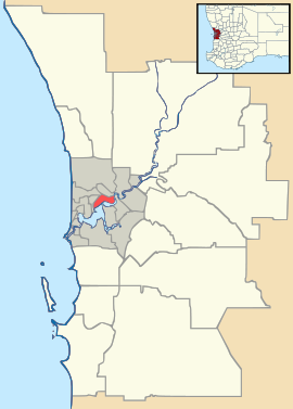
Oakford is located in Perth
{{{alt}}}
Oakford
Population: 2,137 (2006 census)[1]
Postcode: 6121
Area: 46.9 km² (18.1 sq mi)
Location: 36 km (22 mi) S of Perth
LGA: Shire of Serpentine-Jarrahdale
State District: Darling Range
Federal Division: Canning
Suburbs around Oakford:
Banjup Forrestdale Brookdale
Wandi Oakford Darling Downs
Anketell Oldbury Byford

Coordinates: 32°12′43″S 115°55′52″E / 32.212°S 115.931°E / -32.212; 115.931

Oakford is an outer suburb of Perth, Western Australia, within the Shire of Serpentine-Jarrahdale. The suburb was named in 1982, taking its name from a townsite briefly declared in the area in 1926.[2]

References


Wikimedia Foundation. 2010.

Игры ⚽ Нужно сделать НИР?

Look at other dictionaries:

  • Oldbury, Western Australia — Oldbury Perth, Western Australia …   Wikipedia

  • Anketell, Western Australia — Infobox Australian Place | type = suburb name = Anketell city = Perth state = wa caption = lga = Town of Kwinana postcode = 6167 est = pop = 234 (2006 census)Census 2006 AUS|id=SSC51021|name=Anketell (State Suburb)|quick=on|accessdate=2008 10 05] …   Wikipedia

  • Mundijong, Western Australia — Mundijong Perth, Western Australia Paterson Street, Mundijong …   Wikipedia

  • Wandi, Western Australia — Infobox Australian Place | type = suburb name = Wandi city = Perth state = wa caption = lga = Town of Kwinana postcode = 6167 est = pop = 782 (2006 census)Census 2006 AUS|id=SSC52441|name=Wandi (State Suburb)|quick=on|accessdate=2008 10 05] area …   Wikipedia

  • Forrestdale, Western Australia — Infobox Australian Place | type = suburb name = Forrestdale city = Perth state = wa caption = lga = City of Armadale postcode = 6112 pop = 1,297 (2006 census) area = 49.5 est = propval = $381,000 cite web|url=http://reiwa.com/res/res iframe… …   Wikipedia

  • Brookdale, Western Australia — Infobox Australian Place | type = suburb name = Brookdale city = Perth state = wa caption = lga = City of Armadale postcode = 6112 est = 1997 pop = 2,656 (2006 Census) area = 10.0 propval = $276,525 (Q4 2006)cite web|url=http://reiwa.com/res/res… …   Wikipedia

  • Byford, Western Australia — Infobox Australian Place | type = suburb name = Byford city = Perth state = Western Australia caption = lga = Shire of Serpentine Jarrahdale postcode = 6122 est = pop = 3,335 (2006 census) area = propval = stategov = Darling Range fedgov =… …   Wikipedia

  • Casuarina, Western Australia — Infobox Australian Place | type = suburb name = Casuarina city = Perth state = wa caption = lga = Town of Kwinana postcode = 6167 est = pop = 1389 (2006 census)Census 2006 AUS|id=SSC51271|name=Casuarina (State Suburb)|quick=on|accessdate=2008 10… …   Wikipedia

  • Banjup, Western Australia — Infobox Australian Place | type = suburb name = Banjup city = Perth state = wa caption = lga = City of Cockburn postcode = 6164 est = 1900s pop = 1291 (2006 census)Census 2006 AUS|id=SSC51086|name=Banjup (State Suburb)|quick=on|accessdate=2008 10 …   Wikipedia

  • List of major roads in Perth, Western Australia — This page details the major roads in the greater Perth conurbation, in Western Australia.A list of the routes (most involving multiple roads) is available at List of road routes in Perth, Western Australia.Freeways in Perth (by road route… …   Wikipedia

Share the article and excerpts

Direct link
Do a right-click on the link above
and select “Copy Link”