Jalalabad Airport

Jalalabad Airport
Jalalabad Airport
Nangarhar Airport.jpg
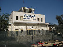
Control tower of the Jalalabad Airport in Nangarhar
IATA: JAAICAO: OAJL
Summary
Location Jalalabad
Elevation AMSL 1,814 ft / 553 m
Coordinates 34°23′57″N 70°29′58″E / 34.39917°N 70.49944°E / 34.39917; 70.49944Coordinates: 34°23′57″N 70°29′58″E / 34.39917°N 70.49944°E / 34.39917; 70.49944
Runways
Direction Length Surface
ft m
13/31 7,276 2,218 Asphalt

Jalalabad Airport (IATA: JAAICAO: OAJL) is located 3 miles (5 km) southeast of Jalalabad city in Afghanistan. This airport is currently being used only for military purposes and sometimes the United Nations' aircraft use this airport.

Contents

New Jalalabad Airport

The construction of a new civilian airport is underway in Gambiri area to north west of Jalalabad.The new airport will be constructed with financial assistance of the US and will be opened in 2011, Hamidullah Qaderi, Minister of Transport and Civil Aviation of Afghanistan, said on April 26, 2009.

2010 attack

On 30 June 2010 a car bomb was set off and militants stormed the airport. According to Zabiullah Mujahid, an Taliban spokesman, the Taliban were responsible and killed 32 Afghan and non-Afghan security forces. According to NATO there were eight Taliban deaths and one Afghan and one coalition member injured.[1][2]

Airlines and destinations

Currently, there are no scheduled airlines operating at Jalalabad Airport.

Cargo

Airlines Destinations
Khyber Afghan Airlines

References

External links


Wikimedia Foundation. 2010.

Игры ⚽ Нужен реферат?

Look at other dictionaries:

  • Jalalabad — Infobox Settlement official name =Jalalkot (Jalalabad) other name = native name =جلال اباد nickname = settlement type = motto = imagesize = 300px image caption = View of an area in Jalalabad in April 2004 flag size = image seal size = image… …   Wikipedia

  • Aéroport de Jalalabad — Code AITA Code OACI JAA OAJL Localisation Pays …   Wikipédia en Français

  • Kandahar International Airport — Aerial view of Kandahar Airport in 2005 IATA: KDH – ICAO: OAKN …   Wikipedia

  • Kabul International Airport — دکابل نړیوال هوایی ډګر میدان هوایی بین المللی کابل IATA: KBL – ICAO: OAKB …   Wikipedia

  • Transport in Afghanistan — Landlocked Afghanistan has almost no railways, but the Amu Darya (Oxus) River, which forms part of Afghanistan s border with Turkmenistan, Uzbekistan, and Tajikistan, has barge traffic. During their occupation of the country, the Soviets… …   Wikipedia

  • Khyber Afghan Airlines — Infobox Airline airline = Khyber Afghan Airlines logo size = fleet size = destinations = IATA = ICAO = KHY callsign = KHYBER parent = company slogan = founded = headquarters = flagicon|Afghanistan Jalalabad, Afghanistan key people = hubs =… …   Wikipedia

  • Abdul Rahman Khowlan — Infobox WoT detainees subject name = Abdul Rahman Mohammed Hussein Khowlan image size = image caption = date of birth = Birth year and age|1972 place of birth = Taif, Saudi Arabia date of death = place of death = detained at = Guantanamo id… …   Wikipedia

  • Dschellalabad — DEC …   Deutsch Wikipedia

  • Dschalalabad — ‏جلال‌ آباد‎ Dschalalabad …   Deutsch Wikipedia

  • Mohammed Atef — There are multiple individuals known as Abu Hafs, or some variation thereof. Mohammed Atef Born 1944,[1] 1951,[2] 1956 …   Wikipedia

Share the article and excerpts

Direct link
Do a right-click on the link above
and select “Copy Link”