- New York State Route 95
-
For the Interstate Highway in downstate New York, see Interstate 95 in New York.
NYS Route 95
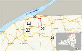
Map of northern New York with NY 95 highlighted in redRoute information Maintained by NYSDOT Length: 13.37 mi[2] (21.52 km) Existed: 1930[1] – present Major junctions South end:  US 11 in Moira
North end:  NY 37 in Bombay
Location Counties: Franklin Highway system Numbered highways in New York
Interstate • U.S. • N.Y. (former) • Reference • County←  I-95
I-95NY 96  →
→New York State Route 95 (NY 95) is a short state highway in northern New York, USA. NY 95 is a north–south route, connecting two towns in Franklin County. The southern terminus is at U.S. Route 11 in the hamlet of Moira in the town of Moira. The northern terminus is at NY 37 east of the hamlet of Hogansburg in the town of Bombay. The highway terminates less than 3 miles (5 km) south of the Canadian border.
Contents
Route description
 Southern terminus of NY 95
In the south, NY 95 begins at US 11 in Moira. Initially parallel to County Route 17, it heads almost due north, intersecting with several local streets. In flat terrain, NY 95 intersects County Route 32 and runs parallel to the Little Salmon River. After a series of turns, it once again heads directly northward. As it enters Bombay, the highway intersects County Route 4 and makes a sharp turn to the west. The Route turns north-northwestward and comes to an end at NY 37, east of Hogansburg.[3]
History
NY 95 was assigned as part of the 1930 renumbering of state highways in New York to an alignment extending from Saint Regis Falls in the south to the vicinity of Hogansburg in the north via Moira.[1][4] It was truncated to its current southern terminus in Moira ca. 1937.[5][6] The former alignment of NY 95 between Saint Regis Falls and Moira is now maintained by Franklin County as County Route 5.[7][8]
Major intersections
The entire route is in Franklin County.
Location Mile[2] Destinations Notes Moira 0.00 US 11Hamlet of Moira Bombay 8.51  CR 4
CR 4Hamlet of Bombay 13.37 NY 371.000 mi = 1.609 km; 1.000 km = 0.621 mi References
- ^ a b Dickinson, Leon A. (January 12, 1930). "New Signs for State Highways". The New York Times: p. 136.
- ^ a b "2008 Traffic Volume Report for New York State" (PDF). New York State Department of Transportation. June 16, 2009. p. 152. https://www.nysdot.gov/divisions/engineering/technical-services/hds-respository/NYSDOT%20TVR%202008%20by%20Route.pdf. Retrieved January 30, 2010.
- ^ Google, Inc. Google Maps – overview map of NY 95 (Map). Cartography by Google, Inc. http://maps.google.com/maps?hl=en&q=from:+RT-95%20@44.819637,%20-74.556260+to:+RT-95%20@44.966200,%20-74.640060. Retrieved May 21, 2008.
- ^ Standard Oil Company of New York (1930). Road Map of New York (Map). Cartography by General Drafting.
- ^ Standard Oil Company (1936). New York (Map). Cartography by General Drafting.
- ^ Standard Oil Company (1937). New York (Map). Cartography by General Drafting.
- ^ New York State Department of Transportation (1969). Brushton Digital Raster Quadrangle (Map). 1:24,000. http://www.nysgis.state.ny.us/gisdata/quads/drg24/dotpreview/index.cfm?code=b42. Retrieved June 6, 2010.
- ^ New York State Department of Transportation (1969). Saint Regis Falls Digital Raster Quadrangle (Map). 1:24,000. http://www.nysgis.state.ny.us/gisdata/quads/drg24/dotpreview/index.cfm?code=c42. Retrieved June 6, 2010.
External links
Categories:- State highways in New York
- Transportation in Franklin County, New York


Wikimedia Foundation. 2010.