- Mount Victoria, Wellington
-
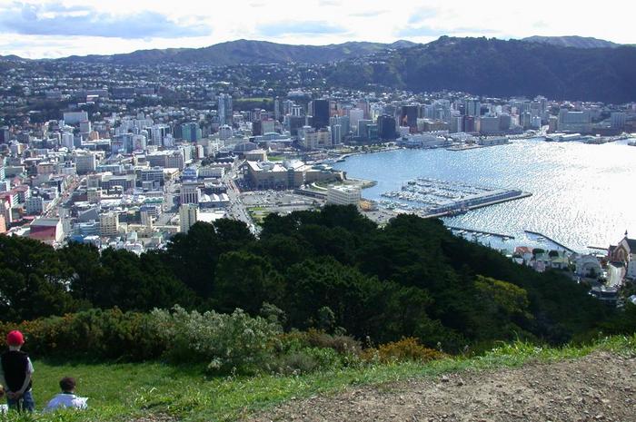
Mount Victoria Basic information Local authority Wellington City Population 5,226 (2006 [1]) Facilities Surrounds North Oriental Bay Northeast Roseneath Southeast Hataitai Southwest Mount Cook West Te Aro Northwest Wellington CBD  A view of Wellington looking north-west from the top of Mount Victoria. In the middle of the image you can see the national museum, Te Papa.
Mount Victoria, locally abbreviated to Mt. Vic, is a prominent hill (height 196 metres) to the east of the centre of Wellington, New Zealand, and its associated suburb. To the south of it is a spur, Mount Albert, and the two are linked by a ridge.
Mount Victoria's original Māori name is Tangi Te Keo. [2]
The suburb of Mount Victoria is a mixture of residential and commercial activity on the western flank of the ridge above the southern end of the Wellington Central Business District. Adjoining suburbs, almost entirely residential, are Oriental Bay, Roseneath and Hataitai.
Government House, the home of New Zealand's Governor-General, lies on the slopes of Mount Victoria to the south of the Basin Reserve, between Mount Victoria and Newtown. Behind it is Wellington Hospital.
The distinctive Byzantine-style domed Greek Orthodox Cathedral is on Mount Victoria's western flank, while the Basin Reserve sports stadium and National War Memorial lie near its foot. Schools in the area include Wellington College, Wellington East Girls' College and Clyde Quay School.
The Hataitai Bus Tunnel and the Mount Victoria Tunnel (SH1) run beneath the ridge, connecting the central city with Wellington International Airport, Evans Bay and the Miramar Peninsula.
Lord of the Rings Connection
Mount Victoria was used twice as a location in Peter Jackson's The Lord of the Rings film trilogy. The very first footage on the project was shot off Alexandra Road on 11th October 1999 Called the "Get off the road" scene. Followed by the “Escape from the Nazgûl” scenes a few hundred metres to the North. Later an old quarry at the top end of Ellice Street was used as the Rohirrim camp at Dunharrow. [3]
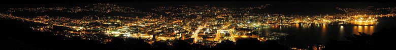 Panorama of Wellington from Mount Victoria at night
External links
- Rotary Club of Mount Victoria
- Local Toastmasters Society
- Mt Victoria Community Website
- Mt Victoria Historical Society
References
- ^ Quickstats about Mt Victoria West
- ^ Manuscripts and Pictorial Collections of the Alexander Turnbull Library Retrieved: 4 April 2009
- ^ Ian Brodie. (2003). The Lord of the Rings Location Guidebook. Harper Collins. ISBN 1-86950-491-7.
Coordinates: 41°17′54″S 174°47′10″E / 41.298383°S 174.786145°E
Categories:- Suburbs of Wellington City
- Wellington Region geography stubs

Wikimedia Foundation. 2010.