- Main Line (Long Island Rail Road)
-
For other uses, see Main Line (disambiguation).LIRR Main Line

Overview Type Commuter rail System Long Island Rail Road Status Operational Locale Long Island, New York, USA Termini Long Island City
GreenportStations 29 passenger, 1 employee-only Services Belmont Park BranchOperation Owner Long Island Rail Road Operator(s) Long Island Rail Road Technical Track gauge 4 ft 8 1⁄2 in (1,435 mm) Electrification Third rail (west of Ronkonkoma) The Main Line is a rail line owned and operated by the Long Island Rail Road in the U.S. state of New York. It begins in Long Island City and runs along the middle of Long Island about 95 miles (153 km) to Greenport. A mile east of Long Island City (east of Hunterspoint Avenue) the four tracks of the East River Tunnels join the two tracks from Long Island City; most Main Line trains use those tunnels rather than running to or from Long Island City.
Continuing east, five branches split from the Main Line; in order from west to east, they are:
- Port Washington Branch (at Wood Interlocking in Woodside, Queens)
- Hempstead Branch (at Queens Interlocking along the Queens/Nassau County border)
- Oyster Bay Branch (at Nassau Interlocking, east of Mineola station)
- Port Jefferson Branch (at Divide Interlocking, east of Hicksville station)
- Central Branch (at Beth Interlocking, east of Bethpage station) - a single track with no stations, connecting the Main Line to the Montauk Branch
Public timetables refer to the Main Line east of Hicksville as the Ronkonkoma Branch.
Trains on the Main Line between Long Island City and Ronkonkoma are governed by Automatic Block and Interlocking Signals and by Automatic Train Control (known as Automatic Speed Control by the LIRR). East of Ronkonkoma to Greenport trains operate in non-signalled or "Dark Territory", with all train movements governed by train orders and timetable authority.
Contents
Route description and current train service
The Main Line has two tracks from just east of Long Island City to Harold Interlocking (0.6 miles [1.0 km] northwest of the Woodside station), where the four tracks from Penn Station in Manhattan join the Main Line after passing through the East River Tunnels. East of Harold[1] the four-track Main Line runs adjacent to the two-track Port Washington Branch until, 0.7 miles (1.1 km) southeast of the Woodside station, the Port Washington Branch turns northeastward. The Main Line continues southeast with four tracks to Jay Interlocking where it meets the Atlantic Branch and Montauk Branch at the west end of Jamaica station. Eight platform tracks and two bypass tracks pass Jamaica station, along with a few yard tracks and two former freight tracks on the south side that can be used by trains bypassing Jamaica. At Hall Interlocking[2] just east of the station there are eight through tracks: two usually-westward tracks for Main Line and Montauk trains, two Atlantic Branch tracks that are about to duck under and turn southeast, two usually-eastward Main Line/Montauk tracks, and the two former freight tracks on the south side of Hall tower.
Just east of there Montauk Branch trains get their own two tracks in the center of the four Main Line tracks until the Montauk tracks fly over[3] the other tracks and head southeast. At Queens Interlocking, just inside Nassau County between the Queens Village and Bellerose stations, the four-track Main Line splits into the two-track Main Line and the two-track Hempstead Branch; the four tracks continue parallel to Floral Park where the Hempstead Branch curves away southward. To just east of Farmingdale Station the Main Line has two tracks, then is single track with passing sidings to Greenport except for a three-mile stretch of double track from west of Deer Park to east of Brentwood. The Main Line was electrified between Hicksville and Ronkonkoma in 1987, requiring construction of high platforms along that stretch. LIRR plans eventually to complete double track to Ronkonkoma.
The Main Line west of Jamaica to Harold Interlocking is the only line that can reach the East River Tunnels, so all trains bound for Penn Station use it. The portion between Harold and the Long Island City station is used by trains originating or terminating at Hunterspoint Avenue and LIC.
 Power station at Nassau Interlocking in Mineola
East of Jamaica Station the Main Line is used by all trains on the Hempstead Branch, the Oyster Bay Branch (diverging east of Mineola), the Port Jefferson Branch (diverging east of Hicksville), and the Ronkonkoma Branch (terminating at Ronkonkoma, the easterly limits of the line's electrification). Some Montauk Branch trains use the Main Line on their way to Babylon via the Central Branch, diverging east of Bethpage.
Only a few diesel shuttle trains, informally known as scoots, operate between Ronkonkoma and Greenport. Weekend service east of Ronkonkoma only operates between Memorial Day and Columbus Day.
History
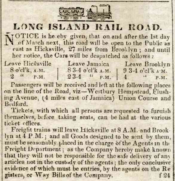
The Main Line opened beyond Jamaica to Hicksville on March 1, 1837; shortly afterwards, the Panic of 1837 severely curtailed construction. It was extended to Farmingdale on October 15, 1841, Deer Park on March 14, 1842, Brentwood on June 24, Central Islip on July 14, and Yaphank on June 26, 1844. An opening excursion to Greenport was operated on July 27, 1844, and revenue service began over the full line on July 29.[4][5][6][7]
Third Main Line track
To accommodate an expected increase in Long Island Rail Road ridership once the East Side Access project to Grand Central Terminal is completed and to expand local and reverse peak service, the Metropolitan Transportation Authority has proposed to build a third Main Line track from Floral Park to Hicksville in the future.[8][9] Components of the project include purchasing properties in the track's right of way, eliminating grade crossings (in conjunction with NYSDOT), relocating existing stations, and reconfiguring Mineola Station. Fierce opposition for building a third track comes from the villages of Floral Park, New Hyde Park, and Garden City,[10][11][12] which say the construction and the resulting increased train service will reduce the quality of life in their neighborhoods. However, these villages do support station improvements and the elimination of grade crossings.
Stations
Hempstead Branch trains run on separate tracks east of Queens Village (and split south, east of Floral Park), Oyster Bay Branch trains split off after Mineola, and Port Jefferson Branch trains split off after Hicksville. Montauk Branch trains that use the Main Line and Central Branch split off after Bethpage, but only some stop at Mineola and Hicksville east of Jamaica.
Jamaica is 11.2 to 11.3 (18 km) from Penn Station.
Station/
locationMiles
(kilometers)
from Jamaica[13]Notes Long Island City 
Hunterspoint Avenue Woodside 5.9 (9.5) Transfer to Port Washington Branch Forest Hills 2.3 (3.7) Kew Gardens 2.0 (3.2) Jamaica 0.0 (0.0) Hillside Facility Employee-only station Hollis
193rd Street and Woodhull Avenue, Hollis2.6 (4.2) Queens Village
Springfield Boulevard and Amboy Lane, Queens Village4.2 (6.8) Floral Park
Tulip Avenue and Atlantic Avenue, Floral Park5.9 (9.5) Hempstead Branch diverges New Hyde Park
New Hyde Park and 2nd Avenue, New Hyde Park7.2 (11.6) Merillon Avenue
Nassau Boulevard and Merillon Avenue, Garden City8.3 (13.4) Mineola
Front Street and Mineola Boulevard, Mineola9.5 (15.3) Oyster Bay Branch diverges Carle Place
Cherry Lane and Atlantic Avenue, Carle Place11.3 (18.2) Westbury
Union Avenue and Post Avenue Westbury12.4 (20.0) Hicksville
Newbridge Road (Route 106) and West Barclay Street, Hicksville15.8 (25.4) Port Jefferson Branch diverges Bethpage
Stewart Avenue and Jackson Avenue, Bethpage18.9 (30.4) Central Branch diverges Farmingdale
Off Secatogue Avenue, on Front Street and Atlantic Avenue, Farmingdale21.2 (34.1) Pinelawn
Wellwood Avenue and Long Island Avenue, Pinelawn Memorial Park23.4 (37.7) Wyandanch
Straight Path and Long Island Avenue, Wyandanch25.7 (41.4) Deer Park
Pine Aire Drive and Long Island Avenue, Deer Park29.4 (47.3) Brentwood
Brentwood Road and Suffolk Avenue, Brentwood32.1 (51.7) Central Islip
Lowell Avenue and Suffolk Avenue, Central Islip36.4 (58.6) Ronkonkoma
Hawkins Avenue and Johnson Avenue, Ronkonkoma39.5 (63.6) easternmost electrified service Medford
Medford Avenue (New York State Route 112) and Long Island Avenue, Medford45.1 (72.6) Yaphank
Yaphank Avenue and Park Street, Yaphank49.6 (79.8) Riverhead
Osborne Avenue and Railroad Street, Riverhead64.1 (103.2) Mattituck
Love Lane and Pike Street, Mattituck73.4 (118.1) Southold
Youngs Avenue and Traveler Street, Southold81.1 (130.5) Greenport
Wiggins Street and 4th Street, Greenport85.3 (137.3) Ferry to Shelter Island and New London, Connecticut Full list, including all former stations
Miles from LIC Name Opened Closed 0.0 Long Island City
earlier Hunter's PointJune 26, 1854 present Hunterspoint Avenue August 1860 present Woodside 1861 present 4.0[14] Winfield 1865 1929 Grand Street 1913 1925 Rego Park 1928 1962 Matawok 1922 1925 Forest Hills 1906 present Hopedale 1875 by 1884 Kew Gardens
originally Maple Grove, then Kew1879
1883
19101882
1909
presentWestbridge
earlier High Bridge1916 1939 Dunton 1897 1939 9.9[14] Jamaica 1836 present Union Hall Street
earlier New York Avenueca. 1890 1976 Canal Street June 24, 1890[15] 1899 10.9[14] Hillside
earlier Rockaway JunctionJune 24, 1890[15] July 1, 1966 Hillside Facility 1991 present Willow Tree ca. 1837 11.9[14] Hollis 1885 present 12.8[14] Bellaire
originally Flushing Avenue, then Brushville, then Interstate Park, then Brushville RoadMarch 1, 1837[16]
1900ca. 1871
197213.6[14] Queens Village
originally Queens1881
1924present Belmont Park 1905 present 14.5[14] Bellerose 1898 present (Hempstead Branch only) 15.3[14] Floral Park
originally Plainfield, then Stewart Junction, then Hinsdale, then East Hinsdale1870s present New Hyde Park
earlier Hyde Parkca. 1837 present Merillon Avenue
originally Clowesville, then Garden City1837 present Mineola
originally Hempstead, then Branch or Hempstead BranchMarch 1, 1837[16] present Carle Place
earlier Carll PlaceMay 1842[17] present Westbury March 1, 1837[16] present New Cassel 1875 Hicksville March 1, 1837[16] present Grumman 1942 1970's Bethpage
originally Jerusalem, then Central Parkby 1854[18] present Bethpage Junction (Beth Interlocking) 1873 closed Farmingdale October 15, 1841[19][20] present Republic 1940 1970's Pinelawn
earlier Melville1890s present Wyandanch
originally West Deer Park, then Wyandance1875 present Edgewood 1892 1914 Deer Park March 14, 1842[21][22] present Pilgrim State Hospital 1978 Thompson June 1842[23] 1869 Pineaire 1915 1986 Brentwood
originally Modern Times1870 present Suffolk August 10, 1842[24] 1873 Central Islip 1873
1916
1958
1987present Central Islip State Hospital Nichols Road Lakeland
earlier Lake Road1843 1883 Ronkonkoma
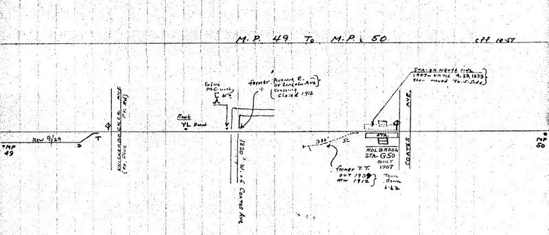
earlier Lake Ronkonkoma1883 present Holbrook 1844 1962[25] Holtsville
earlier Waverly[26]1843 March 16, 1998 Medford June 26, 1844[27] present Bartlett's
earlier Bellport1852 Fire Place June 26, 1844[27] Yaphank
earlier Milleville1844 present Carman's River June 26, 1844[27] 1945 Upton Road 1918 1922 Camp Upton 1917 1922 Wampmissic by 1852 Manorville
originally St. George's Manor, then Manorby 1845 ca. 1968 Calverton
originally Hulse Turnout, then Baiting Hollow1852 ca. 1958 Riverhead 1844 present Aquebogue 1892 c. 1967 Jamesport 1844 1985 Laurel 1901 1967 Mattituck by 1845 present Cutchogue 1844 1962 Peconic
earlier Hermitage1844 ca. 1970 Southold 1844 present Greenport 1844 present References
- ^ from 40°45′03″N 73°54′43″W / 40.75075°N 73.912°W to 40°44′18″N 73°53′38″W / 40.7382°N 73.894°W
- ^ 40°42′01″N 73°48′22″W / 40.70025°N 73.8061°W
- ^ 40°42′21″N 73°47′04″W / 40.70585°N 73.7845°W
- ^ PRR Chronology, 1837PDF (98.8 KiB), June 2004 Edition
- ^ PRR Chronology, 1841PDF (60.7 KiB), May 2004 Edition
- ^ PRR Chronology, 1842PDF (70.6 KiB), May 2004 Edition
- ^ PRR Chronology, 1844PDF (41.4 KiB), May 2004 Edition
- ^ Main Line Corridor Improvements EIS
- ^ Main Line Corridor Improvements Project brochure
- ^ Stephanie Mariel Petrellese (2005-11-11). "Floral Park Mayor To Address LIRR Expansion". The Garden City News. http://www.gcnews.com/news/2005/1111/Front_Page/001.html. Retrieved 2006-12-23.
- ^ Carisa Keane (2005-06-24). "Residents: MTA/LIRR Needs to Get on Right Track". New Hyde Park Illustrated News. http://www.antonnews.com/illustratednews/2005/06/24/news/. Retrieved 2006-12-23.
- ^ Stephanie Mariel Petrellese (2006-12-15). "Village Meets With LIRR On "Third Track" Project". The Garden City News. http://www.gcnews.com/news/2006/1215/Front_Page/001.html. Retrieved 2006-12-23.
- ^ Station pages linked from LIRR Map
- ^ a b c d e f g h Employee timetable, November 5, 1905
- ^ a b "Rapid Transit Extension". Brooklyn Daily Eagle: p. 1. June 24, 1890. http://eagle.brooklynpubliclibrary.org/Default/Scripting/ArchiveView.asp?BaseHref=BEG/1890/06/24&Page=1&skin=BE.
- ^ a b c d Brooklyn Advocate, Long Island Rail Road, February 1837
- ^ "Long Island Railroad Company". Brooklyn Daily Eagle: p. 3. May 28, 1842. http://eagle.brooklynpubliclibrary.org/Default/Scripting/ArchiveView.asp?BaseHref=BEG/1842/05/28&Page=3&skin=BE.
- ^ "RAILROADS". New York Times. 1854-04-13. pp. p7. http://query.nytimes.com/gst/abstract.html?res=9403E5DC153DE334BC4B52DFB266838F649FDE. Retrieved 2008-04-07.
- ^ "The Long Delay at Hicksville". Newsday. http://www.newsday.com/community/guide/lihistory/ny-history-hs515c,0,6895555.story.
- ^ "Brooklyn Eagle v1, #1 (LIRR timetable)". Brooklyn Eagle. 1841-10-26. http://eagle.brooklynpubliclibrary.org/Repository/getimage.dll?path=BEG/1841/10/26/1/Img/Pg001.png. This is the very first edition of the paper. (Whether "late Bethpage" is meant to indicate 1> a flag stop at the community near Merritts Road, or 2> that the area near the Farmingdale LIRR station had lately been called Bethpage, or 3> that the Merrits Road community had been a temporary stop until the Farmingdale station was completed has not yet been determined.)
- ^ "untitled". Brooklyn Daily Eagle: p. 2. March 14, 1842. http://eagle.brooklynpubliclibrary.org/Default/Scripting/ArchiveView.asp?BaseHref=BEG/1842/03/14&Page=2&skin=BE.
- ^ "Long Island Railroad Company". Brooklyn Daily Eagle: p. 3. March 16, 1842. http://eagle.brooklynpubliclibrary.org/Default/Scripting/ArchiveView.asp?BaseHref=BEG/1842/03/16&Page=3&skin=BE.
- ^ "Long Island Railroad". Brooklyn Daily Eagle: p. 2. June 29, 1842. http://eagle.brooklynpubliclibrary.org/Default/Scripting/ArchiveView.asp?BaseHref=BEG/1842/06/29&Page=2&skin=BE.
- ^ "untitled". Brooklyn Daily Eagle: p. 2. August 6, 1842. http://eagle.brooklynpubliclibrary.org/Default/Scripting/ArchiveView.asp?BaseHref=BEG/1842/08/06&Page=2&skin=BE.
- ^ Holbrook Station @ Ronkonkoma MP 49-50; October 1957(TrainsAreFun.com)
- ^ May 13, 1912 Photo @ Ron Zeil collection (Unofficial LIRR History Website)
- ^ a b c "Long Island Railroad Co". Brooklyn Daily Eagle: p. 2. June 24, 1844. http://eagle.brooklynpubliclibrary.org/Default/Scripting/ArchiveView.asp?BaseHref=BEG/1844/06/24&Page=2&skin=BE.
Long Island Rail Road Main routes 

Branch services Freight operations Defunct branches Bethpage · Cedarhurst Cutoff · Creedmoor · Evergreen · Manhattan Beach · Manorville · Northport · Rockaway Beach · Sag Harbor · Southern Hempstead · West Brighton Beach · White Line · WhitestoneAcquired railroads Brooklyn and Jamaica Railroad · Flushing and North Side Railroad · South Side Railroad of Long Island · Central Railroad of Long IslandOther Categories:- Long Island Rail Road
- Transportation in Queens
- Transportation in Nassau County, New York
- Transportation in Suffolk County, New York


Wikimedia Foundation. 2010.