- Ryukyu Islands
-
"Ryukyu" redirects here. For other uses, see Ryukyu (disambiguation).
Ryukyu Islands Native name: 琉球諸島 (Ryūkyū-shotō)[citation needed]
Nansei Islands (南西諸島 Nansei-shotō)[citation needed]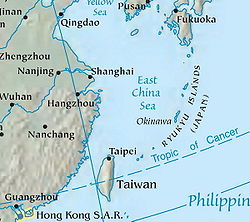
Location of Ryukyu IslandsGeography Location East China Sea Coordinates 26°19′58″N 127°44′56″E / 26.33278°N 127.74889°ECoordinates: 26°19′58″N 127°44′56″E / 26.33278°N 127.74889°E Total islands over 100 Major islands Okinawa Country JapanPrefecture Amami Islands, Kagoshima Prefecture and Ryūkyū Shotō, Okinawa Prefecture Demographics Demonym Ryukyuans The Ryukyu Islands (琉球諸島 Ryūkyū-shotō), also known as the Nansei Islands (南西諸島 Nansei-shotō, literally Southwest Islands),[1] is a chain of islands in the western Pacific, on the eastern limit of the East China Sea and to the southwest of the island of Kyushu in Japan.[2] From about 1829 until the mid 20th century, they were alternately called Luchu, Loochoo, or Lewchew, akin to the Mandarin pronunciation Liuqiu. They stretch southwest from the Japanese island of Kyushu to within 120 kilometres (75 mi) of the island of Taiwan.
The islands are administratively divided into the Satsunan Islands to the north, belonging to Kagoshima Prefecture, and Ryūkyū Shotō to the south, belonging to Okinawa Prefecture. Yoron Island is the southernmost island of the Satsunan Islands, and Yonaguni is the southernmost of the Ryukyu Islands. The largest of the islands is Okinawa Island (沖縄本島 Okinawa-hontō).
The islands have a subtropical climate with mild winters and hot summers. Precipitation is very high, and is affected by the rainy season and typhoons.
The archipelago is home to the Ryukyuan languages. The original languages are native to each island and distinct from one another.
Contents
Naming
Japanese
In Japanese, the definition of the Ryūkyū Shotō (琉球諸島),[3] literally meaning "Ryukyu Islands", is somewhat different from the English definition[4] of the word. In Japanese, the term Ryūkyū Shotō is used to refer to the part of the Nansei Islands which is in Okinawa Prefecture (the southern half), as opposed to islands of the same group located in Kagoshima Prefecture (the northern half).
Modern usage of the word Ryūkyū (琉球) in Japanese, however, is usually replaced by the word Okinawa (沖縄), which is considered its synonym.[5] When referring to the region in the broad sense, the Nansei Islands are sometimes referred to as Amami-Okinawa Chihō (奄美・沖縄地方), literally "Amami-Okinawa Region", or variations thereof.[6] For example, the Japanese train timetables JR Jikokuhyō (JR時刻表) uses variations of Nansei Shotō, Okinawa, Amami, etc., but completely avoids using the word Ryūkyū.[7]
English
In English, until well into the late 19th century (Meiji period in Japan), the word "Ryukyu" was spelled Luchu, Loo-choo, or Lewchew. These spellings were based on the Chinese pronunciation of the characters for "Ryukyu", which in Mandarin is Liúqiú.[8]
History
 Uchinaa flag until 1875
 Main article: History of Ryukyu Islands
The Ryukyu Kingdom was once an independent kingdom occupying the island chain, from Yonaguni Island in the southwest to Amami Ōshima in the north.
In 1609, Shimazu Tadatsune, Lord of Satsuma, invaded the Ryūkyū Kingdom with a fleet of 13 junks and 2,500 samurai, thereby establishing suzerainty over the islands. They faced little opposition from the Ryukyuans, who lacked any significant military capabilities, and who were ordered by King Shō Nei to surrender peacefully rather than suffer the loss of precious lives.[9] After that, the kings of the Ryukyus paid tribute to the Japanese shogun as well as the Chinese emperor. In 1655, the tribute relations between Ryukyu and Qing were formally approved by the shogunate.[10] In 1874, the Ryukyus terminated tribute relations with China.[11]
In 1872, the Japanese government established the Ryukyu han under the jurisdiction of the Foreign Ministry. In 1875, jurisdiction over the Ryukyus changed from the Foreign Ministry to the Home Ministry.[11]
In 1879, the Meiji government announced the annexation of the Ryukyus, establishing it as Okinawa Prefecture and forcing the Ryukyu king to move to Tokyo.[11]
When China signed the Treaty of Shimonoseki after its 1895 defeat in the First Sino-Japanese War, the Chinese officially abandoned its claims to the Ryukyus.[11]
Military activity on the island, before and during World War II, especially the Battle of Okinawa, had a devastating effect on the Okinawan people. A huge loss of civilian life left many feeling that they were being mistreated by both the Japanese and American military.[citation needed] Okinawa remains the poorest prefecture in Japan to this day.[citation needed]
US military control over Okinawa began in 1945 with establishment of the Okinawa Advisory Council. In 1952, the US was formally granted control over Ryukyu Islands south of 29°N latitude, and other Pacific islands, under the San Francisco Peace Treaty between the Allied Powers and Japan. The Okinawa Advisory Council eventually became the government of the Ryukyu Islands which existed from 1952 to 1972. Sovereignty reverted to Japan in 1972.
On February 27, 2010, at 5:31 a.m. local time, a magnitude 7.0 earthquake occurred 80 kilometres (50 mi) east-southeast of Naha at a depth of 22 kilometres (14 mi),[12] but no major damage was reported. At least eight recorded aftershocks were reported, with magnitude up to 5.3[13]
Today, there are a number of issues arising from Ryukyuan history. Some Ryukyuans and some Japanese feel that people from the Ryukyus are different from the majority Yamato people. Some natives of the Ryukyus claim that the central government is discriminating against the islanders by allowing so many American soldiers to be stationed on bases in Okinawa with a minimal presence on the mainland. Additionally, there is some discussion of secession from Japan.[14]
Many popular singers and musical groups come from the Ryukyus. These include the pop groups Begin (ビギン) and Orange Range, as well as singers Namie Amuro and Gackt, among many others.
Historical description of the 'Loo-Choo' islands
An article in the 1878 edition of the 'Globe Encyclopaedia of Universal Information' described the islands as:[15]
-
Loo-Choo, Lu-Tchu, or Lieu-Baeu, a group of thirty-six islands stretching from Japan to Formosa, in 20°-27° 40' N. lat., 126" :o'-!29° 5' E. long., and tributary to Japan. The largest, Tsju San ('middle island') is about 60 miles long and 12 broad; others are Sannan in the S. and Sanbok in the N. Nawa, the chief port of Tsju San, is open to foreign commerce. The islands enjoy a magnificent climate, and are highly cultivated and very productive. Among its products are tea, rice, sugar, tobacco, camphor, fruits, silk, cotton, paper, porcelain, and lacquered ware. The small people seem a link between the Chinese and Japanese.[15]
People
Main article: RyukyuansThe Ryukyuans are known for their longevity. The Okinawa Centenarian Study attributes this phenomenon to a combination of diet, exercise, and lifestyle practices.[citation needed]
Since the most recent Japanese invasion in 1879, Japanese has become the main language on the Ryukyus, especially on Uchinā (Okinawa-honto), through discrimination in education. Middle-aged or younger people tend not to speak a Ryukyuan language as fluently as Japanese, if at all.[citation needed]
Ecology
Nansei Islands subtropical evergreen forests
The Ryukyu Islands are recognized by ecologists as a distinct subtropical moist broadleaf forest ecoregion. The flora and fauna of the islands have much in common with Taiwan, the Philippines, and Southeast Asia, and are part of the Indomalaya ecozone.
Coral reefs
The coral reefs of the Ryukyus are one of the World Wildlife Fund's Global 200 ecoregions. The reefs are endangered by sedimentation and eutrophication, mostly a result of agriculture, as well as damage from fishing.
Major islands
 Map of the major Ryūkyū Islands
 The Yonaguni Monument
 The last sunset in Japan is seen from Yonaguni Island
This list is based on present day Japanese geographic names:
- Nansei Islands
- Satsunan Islands (The Northern Half)
- Ōsumi Islands with:
- Tanegashima, Yakushima, Kuchinoerabujima, Mageshima in the North-Eastern Group,
- Takeshima, Iojima, Kuroshima in the North-Western Group.
- Tokara Islands (The Shichi-tō): Kuchinoshima, Nakanoshima, Gajajima, Suwanosejima, Akusekijima, Tairajima, Kodakarajima, Takarajima
- Amami Islands: Amami Ōshima, Kikaigashima, Kakeromajima, Yoroshima, Ukeshima, Tokunoshima, Okinoerabujima, Yoronjima
- Ōsumi Islands with:
- Ryūkyū Shotō (The Southern Half)
- Okinawa Islands (The Central Group or Ryukyu proper): Okinawa Island (aka. Okinawan mainland, Okinawa hontō), Kumejima, Iheyajima, Izenajima, Agunijima, Iejima, Iwo Tori Shima (Iōtorishima) [16]
- Kerama Islands: Tokashikijima, Zamamijima, Akajima, Gerumajima
- Daitō Islands: Kita daitō, Minami daitō, Oki daitō
- Sakishima Islands ("Further Isles")
- Miyako Islands: Miyakojima, Ikema, Ogami, Irabu, Shimoji, Kurima, Minna, Tarama
- Yaeyama Islands: Iriomote, Ishigaki, Taketomi, Kohama, Kuroshima, Aragusuku, Hatoma, Yubujima, Hateruma, Yonaguni
- Senkaku Islands (claimed by the two Chinas, PRC and ROC): Uotsurijima, Kuba Jima, Taisho Jima, Kita Kojima, Minami Kojima
- Okinawa Islands (The Central Group or Ryukyu proper): Okinawa Island (aka. Okinawan mainland, Okinawa hontō), Kumejima, Iheyajima, Izenajima, Agunijima, Iejima, Iwo Tori Shima (Iōtorishima) [16]
- Satsunan Islands (The Northern Half)
For some of the island names above, the suffix -jima, -shima, and -gashima can be interchanged, omitted, or appended. The suffix means "island." In general, the islands are listed from north to south where possible.
"Shotō" is replaced with "Islands" in the list except for Ryūkyū Shotō (琉球諸島), since the term "Ryukyu Islands" already exists in English. The Japanese term refers only to the islands that comprise Okinawa Prefecture, while the English term refers to the entire chain of islands between Kyushu and Taiwan. Ryūkyū Rettō (琉球列島) refers to what was once the territory of the former kingdom, which are the Amami Islands, Okinawa Islands, Miyako Islands, and Yaeyama Islands.
See also
- History of Ryukyu Islands
- Pechin (Ryukyuan/Okinawan Samurai)
- Ryukyu independence movement
- Ryukyuan music
- Ryukyuan religion
- Ryukyuans (Ryukyuan people)
Notes
- ^ Tsuneyoshi, Ukita (1993). Nihon-dai-chizuchō (Grand Atlas Japan). Heibonsha. ISBN 4-582-43402-9.
- ^ Nussbaum, Louis-Frédéric. (2005). "Ryukyu Islands" in Japan Encyclopedia, p. 801 at Google Books
- ^ "Ryūkyū Shotō (りゅうきゅう‐しょとう【琉球諸島】)". Daijisen dictionary / Yahoo Japan. http://dic.yahoo.co.jp/dsearch?enc=UTF-8&p=%E7%90%89%E7%90%83%E8%AB%B8%E5%B3%B6&stype=0&dtype=2. Retrieved 2007-05-04.
- ^ "Ryukyu Islands". Merriam-Webster's Online Dictionary. http://www.m-w.com/dictionary/Ryukyu%20Islands. Retrieved 2007-05-04.
- ^ "Ryūkyū (りゅうきゅう〔リウキウ〕【琉球】)". Daijisen dictionary / Yahoo Japan. http://dic.yahoo.co.jp/dsearch?enc=UTF-8&p=%E7%90%89%E7%90%83&dtype=0&stype=0. Retrieved 2007-05-06.
- ^ "Radar AMeDAS Live: Amami-Okinawa Region (レーダーアメダス実況 奄美・沖縄地方)". Weather Service Inc. (ウェザー・サービス株式会社). http://www.otenki.co.jp/re-ame/html/okinawa100.html. Retrieved 2007-05-06.
- ^ JR 時刻表 (JR Jikokuhyō). Kotsushinbunsha.
- ^ The Geographical Journal. Royal Geographical Society (Great Britain). 1895.
- ^ Kerr, George H. (2000). Okinawa: the History of an Island People. (revised ed.) Boston: Tuttle Publishing.
- ^ Kang, David C. (2010). East Asia Before the West: Five Centuries of Trade and Tribute, p. 81. at Google Books
- ^ a b c d Lin, Man-houng Lin. "The Ryukyus and Taiwan in the East Asian Seas: A Longue Durée Perspective," Asia-Pacific Journal: Japan Focus. October 27, 2006, translated and abridged from Academia Sinica Weekly, No. 1084. 24 August 2006.
- ^ "Magnitude 7.0 - Ryukyu Islands, Japan". USGS. February 26, 2010. Archived from the original on February 27, 2010. http://www.webcitation.org/5nrnInRAL. Retrieved February 27, 2010.
- ^ Iris.edu
- ^ Masami Ito (May 12, 2009). "OKINAWA: Between a rock and a hard place". The Japan Times. http://search.japantimes.co.jp/cgi-bin/nn20090512i1.html.
- ^ a b Ross, J.M. (editor) (1878). "Globe Encyclopaedia of Universal Information", Vol. IV, Edinburgh-Scotland, Thomas C. Jack, Grange Publishing Works, retrieved from Google Books 2009-03-18;
- ^ http://www.volcano.si.edu/world/volcano.cfm?vnum=0802-02=
References
- Kang, David C. (2010). East Asia Before the West: Five Centuries of Trade and Tribute. New York : Columbia University Press. 13-ISBN 9780231153188/10-ISBN 023115318X; 13-ISBN 9780231526746/10-ISBN 0231526741; OCLC 562768984
- Nussbaum, Louis-Frédéric and Käthe Roth. (2005). Japan encyclopedia. Cambridge: Harvard University Press. 10-ISBN 0-674-01753-6; 13-ISBN 978-0-674-01753-5; OCLC 58053128
- This article incorporates text from the 1878 edition of the Globe Encyclopaedia of Universal Information, a work in the public domain
External links
- Nansei Islands subtropical evergreen forests (World Wildlife Fund)
- A Brief History of the Uchinanchu (Okinawans)
- National Archives of Japan: Ryukyu Chuzano ryoshisha tojogyoretsu, scroll illustrating procession of Ryuku emissary to Edo, Hōei 7 (1710)
Regions and administrative divisions of  Japan
JapanRegions 
Prefectures Hokkaido Tōhoku Kantō Chūbu Kansai Chūgoku Shikoku Kyushu Categories:- Ryukyu Islands
- Ecoregions of Japan
- Marine ecoregions
- Archipelagoes of Japan
-


Wikimedia Foundation. 2010.