- Nab Scar
-
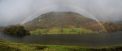 Nab Scar from Rydal Water with rainbow
Nab Scar Cumbria,
 Nab Scar
 England
Elevation 455 m (1,493 ft) Prominence c. 5 m Parent peak Heron Pike Listing Wainwright Location Range Lake District, Eastern Fells Coordinates 54°27′25″N 2°59′46″W / 54.457°N 2.996°WCoordinates: 54°27′25″N 2°59′46″W / 54.457°N 2.996°W Topo map OS Explorer OL5, OL7 OS grid NY356073 Nab Scar is a fell in the English Lake District, an outlier of the Fairfield group in the Eastern Fells. It stands above Rydal Water.
Contents
Topography
Nab Scar is properly the steep terminal face of the southern ridge of Heron Pike, but the name is also given to the whole of the ridge south of Lord Crag. Alfred Wainwright gave it the status of a separate fell in his Pictorial Guide to the Lakeland Fells and that convention is followed here.
The popular Fairfield horseshoe ridge walk either begins or ends with Nab Scar, consensus never having been achieved on the "correct" direction of travel. This route also takes in the additional Wainwrights of Heron Pike, Great Rigg, Fairfield, Hart Crag, Dove Crag, High Pike and Low Pike in a circuit of Rydale.
From the double summit of Heron Pike, a grassy ridge descends south westerly, gradually narrowing until a rougher section falls more steeply at Lord Crag. Beyond here it levels out, curving back a little to the east and passing over a couple of low mounds. The second of these is taken as the summit of Nab Scar. A few hundred yards further on is the scar itself, dropping steeply to the lake with woodland on the lower slopes. On the shore of the lake below the fell is Nab Cottage, past home to various of the Lake Poets. To the west is the little valley of Dunney Beck, separating Nab Scar from a low south western rigg running down from Heron Pike to Town End and the River Rothay. The eastern boundary of Nab Scar is the long, quiet valley of Rydale. All of these waters ultimately meet a Rydal village before turning south for Windermere.
A little to the west of the summit is Dockey Tarn, one of the smallest such bodies of water to be named on Ordnance Survey maps. This shallow, rocky bottomed pool has a fine colony of water starwort.[1]
Summit and view
The summit of Nab Scar bears a large cairn. The view westwards is extensive, with the Central Fells seen to particular effect.[2].
Ascents
The main route of ascent is via the recently repaired path up the ridge from Rydal village. A start can also be made from White Moss car park, climbing up Dunney Beck towards Alcock Tarn before swinging east onto the ridge.
References
- ^ Blair, D:Exploring Lakeland Tarns: Lakeland Manor Press (1993): ISBN 0-9543-9041-5
- ^ Alfred Wainwright: A Pictorial Guide to the Lakeland Fells, Book 1: ISBN 0-7112-2454-4
Categories:- Fells of the Lake District
- Wainwrights


Wikimedia Foundation. 2010.