- Midcontinent Rift System
-
 Geological map of North America showing (in white) the Midcontinent Rift, here labeled Keweenawan Rift. Lake Superior occupies the apex of the rift.
The Midcontinent Rift System (MRS) or Keweenawan Rift is a 2,000 km (1,200 mi) long geological rift in the center of the North American continent and south-central part of the North American plate. It formed when the continent's core, the North American craton, began to split apart during the Mesoproterozoic era of the Precambrian, about 1.1 billion years ago. The rift failed, leaving behind thick layers of rock that are exposed in its northern reaches, but buried beneath later sedimentary formations along most of its western and eastern arms.
Those arms meet at Lake Superior, which is contained within the rift valley. The lake's north shore (illustration) in Ontario and Minnesota defines the northern arc of the rift. From the lake, the rift's eastern arm trends south to central lower Michigan. The western arm runs from Lake Superior southwest through portions of Wisconsin, Minnesota, Iowa, and Nebraska to northeastern Kansas.[1]
Contents
Formation and failure
 Rift rocks are exposed in the buff-colored areas around Lake Superior (black). The buff area on the north margin is the Lake Nipigon area.
The rock formations created by the rift included gabbro and granites from magma and basalts from lava.[2] In the Lake Superior region, the upwelling of this molten rock may have been the result of a hotspot which produced a triple junction.[3] The hotspot made a dome that covered the Lake Superior area. Voluminous basaltic lava flows erupted from the central axis of the rift, similar to the present-day rifting under way in the Afar Depression of the East African Rift system. The southwest and southeast extensions represent two arms of the triple junction while a third failed arm extends north into Ontario as the Nipigon Embayment.[4][5] This failed arm includes Lake Nipigon, Ontario.
It is possible that the rift was the result of extensional forces behind the continental collision of the Grenville Orogeny to the east which in part overlaps the timing of the rift development.[4] Later compressive forces from the Grenville Orogeny likely played a major role in the rift's eventual failure and closure.[4][6] Had the rifting process continued, the eventual result would have been sundering of the North American craton and creation of a sea. The Midcontinent Rift appears to have progressed almost to the point where the ocean intruded.[7] But after about 15–22 million years the rift failed.[6][8] The Midcontinent Rift is the deepest closed or healed rift yet discovered; no known deeper rift ever failed to become an ocean.[7]
The rift today
 Iowa magnetic anomaly map showing the rift curving from the north center to the southwest of the state.[9]
Lake Superior occupies a basin created by the rift.[4] Near the lake rocks produced by the rift can be found on the surface in the Keweenaw Peninsula of Upper Michigan, northwest Wisconsin,[10] and on the North Shore of the lake in Minnesota and Ontario.[2] Similar rocks are exposed as far south as Interstate Park near Saint Paul, Minnesota,[11] but otherwise the rift is buried beneath more recent sedimentary rocks up to 9 km (6 mi) thick.[12] Where buried, the rift has been mapped by gravity anomalies (its dense basaltic rock increases gravity locally),[13] aeromagnetic surveys,[14] and seismic data.[15] A slightly older but possibly related geologic feature is the 2,700,000 km2 (1,000,000 sq mi) Mackenzie Large Igneous Province in Canada, which extends from the Arctic in Nunavut to near the Great Lakes in Northwestern Ontario.[16]
Natural resources
The Proterozoic Nonesuch Shale formation in the Keweenaw Rift contains enough organic carbon (greater than 0.5%) to be considered a potential source rock for petroleum. Oil identified as Precambrian has been found seeping out of the Nonesuch Shale in the White Pine mine in Michigan.[17] A few deep wells have been drilled to explore for oil and gas (so far unsuccessfully), in rift rocks as far southwest as Kansas, making some deep rock samples available.[12] These include two "dry holes" drilled by Amoco: a 7,238 ft (2,206 m) well in Alger County, Michigan in 1987 and 1988, and one in Bayfield County, Wisconsin to a depth of 4,966 ft (1,514 m) in 1992.[18] In 1987 Amoco also drilled a 17,851-foot dry hole that penetrated rift sediments in Iowa.[19]
The Michigan Copper Country in the Upper Peninsula and Isle Royale contains major native copper deposits in Keweenawan-age rocks associated with the rift. A copper mining industry was developed in Precolumbian times, reactivated in the 1840s and continued for more than a century. Low-grade copper and nickel deposits also exist in the Duluth Complex north of the lake, but are not economic to mine.[20]
Gallery
-

A diabase sill forms the upper part of the Sleeping Giant formation near Thunder Bay, Ontario
-

A mafic sill related to volcanism of the Midcontinent Rift System in Thunder Bay
-

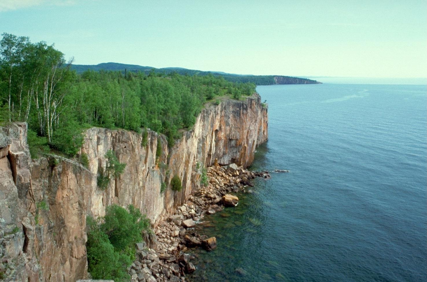
Surficial relics of the Midcontinent Rift: cliffs at Palisade Head and Shovel Point in Minnesota
-

Dalles of the St. Croix River at Interstate State Park, Minnesota-Wisconsin
See also
- Coldwell Complex
- Mamainse Point Formation
- Volcanism of Canada
- Volcanism of Eastern Canada
References
- ^ "Explore for Minnesota Gas". Midcontinent Rift Gas. Minnesota Geological Survey, University of Minnesota. April 2006. http://www.geo.umn.edu/mgs/rift_gas/explore.htm. Retrieved 2007-05-05. Map of Midcontinent Rift area.
- ^ a b Ojakangas, Richard W.; Charles L. Matsch (1982). Minnesota's Geology. Illus. Dan Breedy. Minneapolis, Minnesota: University of Minnesota Press. ISBN 0-8166-0953-5.
- ^ "Middle Proterozoic and The Mid-continent Rift". Minnesota's Rocks and Waters. Winona State University. http://geogroup4.wikispaces.com/file/view/Mid-continentRift.ppt. Retrieved 2008-04-13.(Powerpoint presentation)
- ^ a b c d Van Schmus, W. R.; Hinze, W. J. (May 1985). "The Midcontinent Rift System". Annual Review of Earth and Planetary Sciences 13 (1): 345–83. doi:10.1146/annurev.ea.13.050185.002021. https://kuscholarworks.ku.edu/dspace/bitstream/1808/104/1/fac6cit13.pdf. Retrieved 2007-06-10.
- ^ Kean, William F. (2000-11-24). "Keweenawan Rift System". Field Trips, Northern Wisconsin and Upper Michigan. University of Wisconsin-Milwaukee. http://www.uwm.edu/People/wkean/fieldtrip/ArCraig/keewenaw.htm. Retrieved 2007-06-08.
- ^ a b Ojakangas, R. W.; G. B. Morey and J. C. Green (2001-06-01). "The Mesoproterozoic Midcontinent Rift System, Lake Superior Region, USA". Sedimentary Geology 141–142: 421–442. doi:10.1016/S0037-0738(01)00085-9. http://www.sciencedirect.com/science?_ob=ArticleURL&_udi=B6V6X-436N4CX-M&_user=10&_rdoc=1&_fmt=&_orig=search&_sort=d&view=c&_acct=C000050221&_version=1&_urlVersion=0&_userid=10&md5=2aeeab5d2f46d23bc454bf9b3f967422. Retrieved 2008-04-15. (Abstract)
- ^ a b Reeves, T.K.; Carroll, Herbert B. (April 1999). "Geologic Analysis of Priority Basins for Exploration and Drilling". U.S. Department of Energy, Office of Scientific and Technical Information. http://www.osti.gov/bridge/servlets/purl/6060-JKD5at/webviewable/6060.PDF. Retrieved 2007-06-10.
- ^ Schneider, D. A.; D. K. Holm and V. Chandler (Fall 2006). "A Superior Swath: Proterozoic Geology of the North American Midcontinent". American Geophysical Union. Abstract #T42A-06. http://adsabs.harvard.edu/abs/2006AGUFM.T42A..06S. Retrieved 2008-04-15.
- ^ Kucks, Robert P.; Hill, Patricia L. (2005). "Iowa magnetic and gravity maps and data". U.S. Geological Survey. http://tin.er.usgs.gov/catalog/cite-view.php?cite=64. Retrieved 2009-09-03.
- ^ Anderson, Raymond R.. "Midcontinent Rift System in Iowa". Iowa Department of Natural Resources Geological Survey. http://www.igsb.uiowa.edu/Browse/rift/mrs.htm. Retrieved 2007-06-10.
- ^ Jol, Harry M. (2006). "Interstate State Park, A Brief Geologic History". University of Wisconsin at Eau Claire. http://www.uwec.edu/jolhm/Interstate2006/history.htm. Retrieved 2007-06-10.
- ^ a b Palacas, James G. (1995). "Superior Province (051)". National Oil and Gas Assessment. United States Geological Survey. http://certmapper.cr.usgs.gov/data/noga95/prov51/text/prov51.pdf. Retrieved 2007-06-10.
- ^ Daniels, David L.; Snyder, Stephen L. (2006). "Bouguer gravity anomaly map of north-central United States". Minnesota Geological Survey. http://www.geo.umn.edu/mgs/nicegeo/pdfs/boug_grav.pdf. Retrieved 2007-06-10.
- ^ Daniels, David L.; Snyder, Stephen L. (2006). "Shaded-relief map, total magnetic intensity anomaly". Minnesota Geological Survey. http://www.geo.umn.edu/mgs/nicegeo/pdfs/shd_tfmag.pdf. Retrieved 2007-06-10.
- ^ Hinze, W.; Kellogg, D.; and Merritt, D. (1971). "Gravity and Aeromagnetic Anomaly Maps of the Southern Peninsula of Michigan". Report of Investigation 14. Michigan State Geological Survey. http://www.michigan.gov/documents/deq/GIMDL-RI14_216260_7.pdf. Retrieved 2007-06-10.
- ^ Continental tectonics
- ^ J.A. Seglund, "Midcontinent rift continues to show promise as petroleum prospect," Oil and Gas Journal, 15 May 1989, p.55-58.
- ^ Albert B. Dickas, Results of the Middle Proterozoic Midcontinent rift frontier play along Lake Superior's south shore, Oil & Gas Journal, 18 September 1995, pp. 80–82.
- ^ Iowa Geological Survey: Exploring the Midcontinent Rift (PDF document)
- ^ Jira, Mark; David Southwick (2000-10-12). "Mineral potential and geology of the Duluth Complex". Mineral Potential and Geology of Minnesota. Minnesota Geological Survey, University of Minnesota. http://www.geo.umn.edu/mgs/mnpot/dcmplx.html. Retrieved 2008-04-13.
Large igneous provinces Brazilian Highlands · Caribbean · Central Atlantic · Circum–Superior · Columbia River · Deccan · Emeishan · Ethiopian Highlands · Franklin (Franklin dike swarm) · High Arctic (Sverdrup Basin) · Karoo-Ferrar · Kerguelen · Marathon · Keweenawan · Long Range · Mackenzie (Coppermine River · Mackenzie dike swarm) · Matachewan · Mistassini · North Atlantic · Ontong Java-Manihiki-Hikurangi · Paraná and Etendeka · Siberian · Ungava · WinagamiCategories:- Aulacogens
- Structural geology
- Plate tectonics
- Geologic provinces of the United States
- Geology of Michigan
- Geology of Minnesota
- Geology of Nebraska
- Geology of Iowa
- Geology of Wisconsin
- Geology of Kansas
- Volcanism of Ontario
- Proterozoic
- Large igneous provinces
-


Wikimedia Foundation. 2010.