- U.S. National Geodetic Survey
-
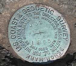 Closeup of a Geodetic Survey marker
National Geodetic Survey, formerly called the U.S. Coast and Geodetic Survey (U.S.C.G.S.), is a United States federal agency that defines and manages a national coordinate system, providing the foundation for transportation and communication; mapping and charting; and a large number of applications of science and engineering. Since 1970, it has been part of the National Oceanic and Atmospheric Administration (NOAA), of the U.S. Department of Commerce.
Contents
History
Earliest years
 Logo celebrating the 200th anniversary of the U.S. Coast and Geodetic Survey
The original predecessor agency of the NGS was the United States Coast Survey, created by Congress in 1807 to conduct a "Survey of the Coast".[1] This organization represented the Jefferson administration's interest in science and stimulation of international trade. The Jackson administration expanded and extended the coast surveys scope and organization.[2]:468 Progress moved ahead slowly and haltingly during the first 25 years. Not until August 29, 1811, did F. R. Hassler sail for Europe to purchase the proper instruments. He remained in Europe during the War of 1812, and then he returned to the United States, arriving on August 16, 1815.
Hassler's plan was to employ triangulation to establish his system. Work began in the vicinity of New York City in 1816. The first baseline was measured and verified in 1817. A further Act of Congress in 1818 interfered with Hassler's work. The U.S. Army and U.S. Navy were placed in charge of the survey work. This generated a lull in activity which lasted from 1818 to 1832. The Coast survey existed without a superintendent during the 14 years from 1818 to 1832.
Little work was carried out until another Federal law was enacted on July 10, 1832. It renewed the original law of 1807. Hassler was reappointed as the agency's superintendent, and field work was resumed in April 1833.
The U.S. Department of the Navy was given the control of the coast and geodetic survey from 1834 to 1836, but the U.S. Department of the Treasury resumed the administration of the survey on March 26, 1836. Hassler passed away in 1843.
Growth years
Professor Alexander Dallas Bache became superintendent of the Survey in 1843. Earlier in his life, he had established the first magnetic observatory. During his years as superintendent, he expanded the Survey southward along the Atlantic coast into the Florida Keys. He instituted regular and systematic observations of the tides and the Gulf Stream, and investigated magnetic forces and directions.
During the nineteenth century, the remit of the Survey was rather loosely drawn and it had no competitors in federally funded scientific research. Various Superintendents developed its work in fields as diverse as astronomy, cartography, meteorology, geodesy, geology, geophysics, hydrography, navigation, oceanography, exploration, pilotage, tides and topography. The Survey published important articles by Charles Sanders Peirce on the design of experiments and on a criterion for the statistical treatment of outliers.[3] For example, from 1836 until the establishment of the National Bureau of Standards in 1901, the Survey was responsible for weights and measures throughout the United States.
 Survey of the Mississippi River below Forts Jackson and St. Philip to prepare for the bombardment of the forts by Porters mortar fleet. Plan done by the U.S. Coast Survey.[4]
Civil War
The outbreak of the American Civil War caused a dramatic shift in direction for the Coast Survey. Since most men of the survey had Union sympathies, their work shifted emphasis to support of the United States Navy. One of the individuals who excelled at this work was Joseph Smith Harris, who supported Admiral David G. Farragut and his Western Gulf Blockading Squadron in the Battle of Forts Jackson and St. Philip. This survey work was particularly valuable to Commander David Dixon Porter and his mortar bombardment fleet.
As the American continent was progressively explored, inhabited, and enclosed, the bureau took responsibility for survey of the interior. By 1871, Congress expanded its responsibilities to include geodetic surveys in the interior of the country and the name of the agency was changed in 1878 to the U.S. Coast and Geodetic Survey (C&GS).[1]
ESSA / NOAA years
From 1965 to 1970, the C&GS was transferred to the control of the Environmental Science Services Administration.[1] In 1970, ESSA expanded and was reorganized into the National Oceanic and Atmospheric Administration (NOAA), of which the NGS is a constituent unit today.[1]
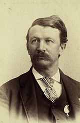 Frank Manly Thorn served as 6th Superintendent of the USC&GS.
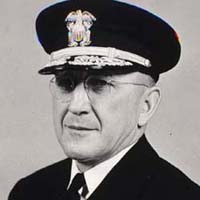
 Rear Admiral Henry Arnold Karo served as the 4th head of USC&GS.
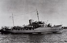 The USC&GS oceanographic research ship Pathfinder was re-commissioned as a US Navy vessel during World War II.
Leadership
Superintendents (1816–1919)
- Ferdinand Rudolph Hassler, (1816–1818 and 1832–1843)
- Alexander Dallas Bache, (1843–1865)
- Benjamin Peirce, (1867–1874)
- Carlile Pollock Patterson, (1874–1881)
- Julius Erasmus Hilgard, (1881–1885)
- Frank Manly Thorn, was the first non-scientist to head USC&GS (1885–1889)
- Thomas Corwin Mendenhall, (1889–1894)
- William Ward Duffield, (1894–1897)
- Henry Smith Pritchett, (1897–1900)
- Otto Hilgard Tittmann, (1900–1915)
- Ernest Lester Jones, (1915–1919)
Directors (1919–1968)
- Ernest Lester Jones, (1919–1929)
- Raymond Stanton Patton, (1929–1937)
- Robert Francis Anthony Studds, (1938–1955)
- Henry Arnold Karo, (1955–1965)
- James C. Tison, Jr., (1965–1968)
Superintendents of Weights and Measures
- Ferdinand Rudolph Hassler (c. 1818–1843)
- Joseph Saxton, (1843–1873);
Ships
See also Category: Ships of the United States Coast and Geodetic Survey.A partial list of the Survey's ships:
- USC&GS A. D. Bache
- Hassler
- USC&GS Thomas R. Gedney
- USC&GS Guide (1918)
- USC&GS Guide (1929)
- USC&GS Yukon (1873)
- USC&GS Carlile P. Patterson
- USC&GS Yukon (1898)
- USC&GS Oceanographer
- USC&GS Pathfinder
- USC&GS Pioneer (1918), in service 1922–1941
- USC&GS Pioneer (1929), in service 1941–1942
- USC&GS Pioneer (OSS 31), in service 1946–1966
- USC&GS Silliman
- USC&GS Barataria (1867)
 The United States Coast and Geodetic Survey flag, in use from 1899 to 1970
Flag
The Coast and Geodetic Survey was authorized its own flag on January 16, 1899. The flag, which remained in use until the Survey became a part of NOAA in 1970, was blue, with a central white circle and a red triangle centered within the circle. It was intended to symbolize the triangulation method used in surveying. The flag was flown by ships in commission with the Coast and Geodetic Survey at the highest point on the forwardmost mast, and served as a distinguishing mark of the Survey as a separate seagoing service from the Navy, with which the Survey shared a common ensign.
The NOAA service flag, in use today, was adapted from the Coast and Geodetic Survey flag by adding the NOAA emblem—a circle divided into two parts by the white silhouette of a flying seabird, with the roughly triangular portion above the bird being dark blue and the portion below it a lighter blue—to the center of the old Survey flag. The NOAA symbol lies entirely within the red triangle.[5]
See also
- Height Modernization
- Hydrography
- Topography
- Surveying
- Nautical Chart
- International maritime signal flags
- Lists of flags
Notes
- ^ a b c d NOAA, Coast and Geodetic Survey Heritage
- ^ Howe, Daniel W. (2007). What hath God Wrought, The Transformation of America, 1815–1848. Oxford University Press, Inc.. ISBN 978-0-19-507894-7.
- ^
- Peirce, Charles Sanders (1870 [published 1873]). "Appendix No. 21. On the Theory of Errors of Observation". Report of the Superintendent of the United States Coast Survey Showing the Progress of the Survey During the Year 1870: 200–224.. NOAA PDF Eprint (goes to Report p. 200, PDF's p. 215). U.S. Coast and Geodetic Survey Annual Reports links for years 1837–1965. Reprinted in Writings of Charles S. Peirce, v. 3, pp. 140–160.
- Peirce, C. S. (1876 [published 1879]), "Appendix No. 14. Note on the Theory of the Economy of Research" in Report of the Superintendent of the United States Coast Survey Showing the Progress of the Survey for Fiscal Year Ending with June 1876, pp. 197–201, NOAA PDF Eprint, goes to p. 197, PDF's page 222. Reprinted in Collected Papers of Charles Sanders Peirce, v. 7, paragraphs 139–157 and in Operations Research v. 15, n. 4, July–August 1967, pp. 643–648, abstract at JSTOR Peirce, C. S. (1967). "Note on the Theory of the Economy of Research". Operations Research 15 (4): 643. doi:10.1287/opre.15.4.643.
- ^ Official Records of the Union and Confederate Navies, Series I, Volume 18, p.362.
- ^ Sea Flags: National Oceanic and Atmoshperic Administration at verizon
External links
- National Geodetic Survey website
- Timeline at Arlington National Cemetery website
- Explanation of survey monuments
- 1858 map: Preliminary chart of entrance to Brazos River hosted by the Portal to Texas History.
- 1853 map: Preliminary chart of San Luis Pass, Texas hosted by the Portal to Texas History.
- 1854 map: Preliminary survey of the entrance to the Rio Grande, Texas hosted by the Portal to Texas History.
Categories:- Geodesy
- National Oceanic and Atmospheric Administration
- Government agencies established in 1807


Wikimedia Foundation. 2010.