- Cleveleys
-
Coordinates: 53°52′52″N 3°02′24″W / 53.881°N 3.040°W
Cleveleys 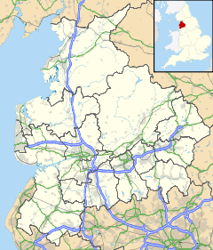
 Cleveleys
Cleveleys shown within LancashireOS grid reference SD317433 District Wyre Shire county Lancashire Region North West Country England Sovereign state United Kingdom Post town THORNTON-CLEVELEYS Postcode district FY5 Dialling code 01253 Police Lancashire Fire Lancashire Ambulance North West EU Parliament North West England UK Parliament Blackpool North and Cleveleys List of places: UK • England • Lancashire Cleveleys (with its neighbouring village of Thornton, collectively known as Thornton-Cleveleys) is a town on the Fylde Coast of Lancashire, England, about 4 miles north of Blackpool and 2 miles south of Fleetwood. It is part of the Borough of Wyre.
Contents
History
At the start of World War II, several departments of the Ministry of Pensions, the Ministry of Education and the Board of Trade were moved to the Cleveleys area. Some were housed in the Rossall School briefly. An extensive site was developed for the Ministry of Pensions in the Norcross section of Carleton and all the government departments moved out in 1940.
Cleveleys is the hometown of published author Malcolm Brocklehurst. His works include 'The Secret history of Christianity'2008 and 'The House of cavendish~Outroads' 2010
On 1 February 2008, the MS Riverdance ferry, while undertaking a regular sailing from Northern Ireland to Heysham under severe stormy conditions, ran aground on the beach, close to the boundary with Blackpool.[1]
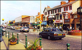
 Victoria Road, Cleveleys
Transport
Cleveleys is well served by Blackpool Transport, who serve the town with regular bus services. Services 1, 3, 4, 7, 9 and 16 all serve the town centre, all of which have regular frequencies of up to ten minutes maximum. Bus services operate to Bispham, Blackpool town centre, Mereside, Lytham, Bispham and Fleetwood.
Stagecoach North West routes 74, 84 and 86 also serve Cleveleys.
Cleveleys is also served by the Blackpool Tramway, although currently as of August 2011 the tramway has temporarily been terminated at Little Bispham as a result of engineering work. The tramway is expected to re-open back at Cleveleys towards Christmas 2011. The tramway runs from Starr Gate in Blackpool, to the Pleasure Beach, through landmarks in Blackpool, Bispham, Cleveleys, Thornton and Fleetwood.
The nearest railway station to Cleveleys is in Poulton-le-Fylde, 31⁄2 miles away.
References
- ^ "BBC News report". 2008-02-04. http://news.bbc.co.uk/1/hi/england/lancashire/7226523.stm. Retrieved 2008-02-05.
External links
Ceremonial county of Lancashire North West England Portal Unitary authorities Boroughs or districts Major settlements Accrington • Adlington • Bacup • Barnoldswick • Blackburn • Blackpool • Brierfield • Burnley • Burscough • Carnforth • Chorley • Clayton-le-Moors • Cleveleys • Clitheroe • Colne • Darwen • Earby • Fleetwood • Garstang • Great Harwood • Haslingden • Kirkham • Lancaster • Leyland • Longridge • Lytham St Annes • Morecambe • Nelson • Ormskirk • Oswaldtwistle • Padiham • Penwortham • Poulton-le-Fylde • Preesall • Preston • Rawtenstall • Rishton • Skelmersdale • Wesham • Whitworth
See also: List of civil parishes in LancashireRivers Canals Topics Categories:- Towns in Lancashire
- Geography of Wyre
- The Fylde
- Populated coastal places in Lancashire

Wikimedia Foundation. 2010.