- Tijeras Canyon
-
-
- Not to be confused with Tijeras Canyon Creek, a tributary of Trabuco Creek.
 Deadman's curve on old Route 66
Tijeras Canyon is a prominent canyon in the central part of the US state of New Mexico. Tijeras Canyon is often referred to by locals as the I-40 Canyon after the major highway that traverses it, linking Albuquerque and points east. It separates the Sandia Mountains to the north from the Manzano Mountains to the south. (The two ranges can also be considered parts of one larger mountain chain.) Elevations along the bottom of the canyon range from 5,600 feet (1,700 m) to 7,000 feet (2,100 m) above sea level.[1] The canyon drains to the west, into a large dry wash known as Tijeras Arroyo, which runs through Kirtland Air Force Base, passes just south of the Albuquerque International Airport, and then joins the Rio Grande. It heads at a historically important pass, and this pass and the entire canyon are traversed by Interstate 40, following the path of historic U.S. Route 66. (Route 66 originally passed through Santa Fe and entered Albuquerque from the North. In 1937 Governor Arthur Hannett re-routed the road away from Santa Fe and through Tijeras Canyon as revenge on politicians who he perceived had thwarted his re-election.[2]) However the railroad was not routed through this pass, instead skirting around the south end of the Manzano Mountains through Mountainair and Belen.
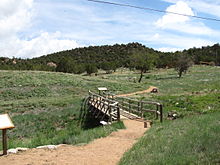 Tijeras Pueblo archeological site
The name Tijeras means "scissors" in Spanish, and the name is said to come from the junction of two tributary canyons, or perhaps of two roads.[2][3] The name is most properly applied only the small village, Tijeras, at the junction, as the original name of the canyon was Cañon de Carnué. However the name Tijeras is now almost universally applied to the canyon.
The original inhabitants of the canyon were Pueblo people, occupying Tijeras Pueblo near the site of the present-day town of Tijeras, but the site has long been deserted.[3]
 The cement plant
The largest employer in the Canyon is a cement plant which opened in the late 1950s. Its buildings and excavations dominate the portion of the canyon and surrounding hills southwest of the town of Tijeras.[2]
References
- ^ Tijeras Canyon on TopoQuest
- ^ a b c Mike Smith, Towns of the Sandia Mountains, Arcadia Publishing, 2006, ISBN 0-7385-4852-9.
- ^ a b Robert Julyan, The Place Names of New Mexico (Revised Edition), University of New Mexico Press, 1998, ISBN 0-8263-1689-1
External links
Coordinates: 35°04′51″N 106°23′15″W / 35.0808°N 106.3875°W
 State of New Mexico
Topics Delegations · Geography · Government · History · Landmarks · Military · Natural history · New Mexicans · Settlements · Transportation · Tribes · Visitor attractions
Society Culture · Demographics · Economy · Education · Politics
Regions Cities Alamogordo · Albuquerque · Artesia · Carlsbad · Clovis · Corrales · Deming · Española · Farmington · Gallup · Grants · Hobbs · Las Cruces · Las Vegas · Los Alamos · Los Lunas · Lovington · Portales · Raton · Rio Rancho · Roswell · Ruidoso · Santa Fe · Silver City · Socorro · Sunland Park · Taos · Tucumcari
Counties Bernalillo · Catron · Chaves · Cibola · Colfax · Curry · De Baca · Doña Ana · Eddy · Grant · Guadalupe · Harding · Hidalgo · Lea · Lincoln · Los Alamos · Luna · McKinley · Mora · Otero · Quay · Rio Arriba · Roosevelt · Sandoval · San Juan · San Miguel · Santa Fe · Sierra · Socorro · Taos · Torrance · Union · Valencia
Categories:- Canyons and gorges of New Mexico
- Landforms of Bernalillo County, New Mexico
-


Wikimedia Foundation. 2010.