- Tappan Zee Bridge
-
Tappan Zee Bridge 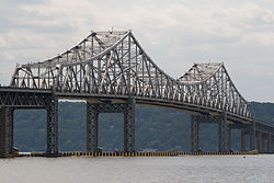
Official name The Governor Malcolm Wilson Tappan Zee Bridge Carries 

 7 lanes (3 northbound, 3 southbound, 1 reversible) of I-87/I-287 (New York State Thruway)
Crosses Hudson River Locale Connecting South Nyack, Rockland County, New York and Tarrytown, Westchester County, New York Maintained by New York State Thruway Authority Design Cantilever bridge Total length 16,013 feet (4,881 m) Width 90 feet (27 m) Longest span 1,212 feet (369 m) Clearance below 138 feet (42 m) Opened December 15, 1955 Toll (eastbound/southbound only)
$4.75 (E-ZPass)[2]
$5.00 (cash)[1]Daily traffic 133,445 (2008)[3] Coordinates 41°04′12″N 73°53′28″W / 41.07°N 73.89111°WCoordinates: 41°04′12″N 73°53′28″W / 41.07°N 73.89111°W The Governor Malcolm Wilson Tappan Zee Bridge, usually referred to as Tappan Zee Bridge, is a cantilever bridge in New York over the Hudson River at one of its widest points; the Tappan Zee is named for an American Indian tribe from the area called "Tappan"; and zee being the Dutch word for "sea".[4] It connects Nyack in Rockland County with Tarrytown in Westchester County. Federal and state authorities are currently planning a Tappan Zee replacement bridge, with estimated completion in 2017.
The total length of the bridge and approaches is 16,013 feet (4,881 m). The cantilever span is 1,212 feet (369 m) providing a maximum clearance of 138 feet (42 m) over the water. The bridge is about 25 miles (40 km) north of midtown Manhattan; the skyline can be seen from the bridge on a clear day.
The bridge is part of the New York State Thruway mainline, and also designated as Interstate 87 and Interstate 287. The span carries seven lanes of motor traffic. The center lane can be switched between eastbound and westbound traffic depending on the prevalent commuter direction; on weekdays, the center lane is eastbound in the morning and westbound in the evening. The switch is accomplished via a movable center barrier which is moved by a pair of barrier transfer machines. Even with the switchable lane, traffic is frequently very slow. The bridge is one of the primary crossings of the Hudson River north of New York City; it carries much of the traffic between southern New England and points west of the Hudson.
As of January 2009[update], eastbound passenger car pays a toll of $5.00 cash, or $4.75 via E-ZPass. The "Commuter Plan" charges $3 per trip. If using fewer than 13 trips per month, the Commuter Plan can be more expensive than paying cash, as you must pay $3 for every trip you did not take under 20 trips.[5]
Contents
History
With the increasing demands for commuter travel taxing the existing bridges and tunnels, the Port Authority of New York and New Jersey had plans in 1950 to construct a bridge across the Hudson near Dobbs Ferry. The proposal was overridden by New York State Governor Thomas E. Dewey, who wanted to construct a bridge to connect the New York State Thruway across Westchester to the New England Thruway. The Port Authority promised its bondholders that it would not allow any other entity to construct a river crossing within its jurisdiction, which reached to a point one mile (1.6 km) south of Nyack and across to Piermont.[6]
A May 10, 1950 editorial in The New York Times suggested that a site in southern Dobbs Ferry or northern Hastings-on-Hudson, where the Hudson narrowed considerably from its three-mile (5 km) width at Tappan Zee, would be a more appropriate site, and suggested that Governor Dewey work with his counterpart, Governor of New Jersey Alfred E. Driscoll, to craft a compromise that would offer Thruway customers a discounted bridge fare at a more southerly crossing.[7] Two days later, Governor Dewey announced that the Port Authority had dropped its plans to construct a bridge of its own. The location would be close to the Tarrytown-Nyack line just outside the Port Authority's jurisdiction. Dewey stated that World War II military technology would be used in the bridge's construction.[8]
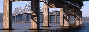
The site of the bridge, at the Hudson River's second-widest point, added to construction costs. The site was chosen to be as close as possible to New York City, while staying out of the 25-mile (40 km) range of the Port Authority's influence, thus ensuring that revenue from collected tolls would go to the newly-created New York State Thruway Authority, and not the Port Authority.[9][10][11] A unique aspect about the design of the bridge is that the main span is supported by eight hollow concrete caissons. Their buoyancy supports some of the loads and helped to reduce costs.[12]
Construction started in March 1952 and the bridge opened for traffic on December 15, 1955, along with a 27-mile (43 km) long section of the New York State Thruway from Suffern to Yonkers.[13][14] New York State Governor W. Averell Harriman signed a bill on February 28, 1956 to name the structure officially the Tappan Zee Bridge.[15] In 1994, the name of Malcolm Wilson was added to the bridge's name upon the 20th anniversary of his leaving the governor's office in December 1974, though it is almost never used when the bridge is spoken about colloquially.[16]
In 2009, the Tappan Zee Bridge was featured on The History Channel "The Crumbling of America" showing the infrastructure crisis in the United States.[17]
On November 7, 2011 around 10:40 am EST, Michael Davitt, 54, of West Haverstraw, NY staged a protest on the bridge. Davitt drove his van onto the center of the bridge and lowered himself off the bridge using a rope ladder. Davitt had a sign, which said "Rockland Executive Legislative Cover up Retaliation" along with food, hanging at the midpoint between the bridge and the Hudson River. This protest was in response to his wrongful firing when he worked for the county in 2008. Davitt "was separated from the County service in 2008 because he was no longer able to perform his essential job functions as a Substance Abuse Counselor 1" as stated by the Rockland County Executive's Office. Davitt was employed from 1991 to 2008 by the Department of Mental Health in Ponoma. As a result of the protest, traffic came to a slow to a standstill. Two lanes on the Westchester bound of the the bridge were closed as the police and fire departments responded to the incident. Helicopters as well as boats from the fire department circled the protester. The traffic extended into the Palisades Parkway. The ordeal finally ended around 2:00 pm EST, as Michael Davitt was lowered down, dropped into the river in an attempt to swim away from the police. He was caught and was arrested. [18]
Proposed replacement
Main article: New Tappan Zee Bridge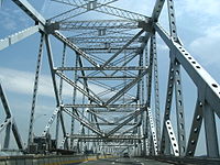 The superstructure was constructed during a period of material shortages during the Korean War.
The deteriorating structure, which bears far more traffic than it was designed for, has led to plans to repair the bridge or replace it with a tunnel or a new bridge.[19][20] These plans and discussions were whittled down to six options and underwent environmental review. Part of the justification for the replacement of the bridge has been that it was constructed during material shortages during the Korean War and designed to last only 50 years.[21] The collapse of the I-35W Mississippi River bridge in Minnesota on August 1, 2007 has renewed concerns about the bridge's structural integrity.[22]
The Metropolitan Transportation Authority (MTA) is studying the feasibility of either including a rail line across the new bridge or building the new bridge so a new rail line can be installed at a future date. The rail line, if built, will be located on a lower level, beneath the roadway. Commuter rail service west of the bridge in Rockland County is limited, and the MTA is studying expansion possibilities in Rockland County that would use the new bridge to connect with Metro-North's Hudson Line on the east side of the bridge along the Hudson River for direct service into Manhattan.
On September 26, 2008, New York state officials announced their plan to replace the Tappan Zee Bridge with a new bridge that includes commuter-train tracks and lanes for high-speed buses. The bridge would cost $6.4 billion, while adding bus lanes from Suffern to Port Chester would cost $2.9 billion. Adding a rail line from the Suffern Metro-North station and across the bridge, connecting with Metro-North’s Hudson Line south of Tarrytown, would cost another $6.7 billion. The plan is being reviewed for environmental impact.[23]
Meetings by the New York State of Transportation with local communities were held in December 2009. They revised the replacement cost including road, rail, and bus to be $16 billion.[24]
Suicide prevention
 The Tappan Zee Bridge as seen from a train on the eastern shore of the Hudson River.
From 1998 to 2008, more than 25 people committed suicide on the Tappan Zee Bridge, according to the New York State Thruway Authority.[25] On August 31, 2007, NYSTA officials added four phones – two each on the Rockland and Westchester sides – that connect callers via the National Suicide Prevention Lifeline suicide prevention hotline to counselors at LifeNet or Covenant House. Signs reading "Life is Worth Living" and "When it seems like there is no hope, there is help" have been placed on the bridge.[26]
The most famous and notorious suicides that happened on the Tappan Zee Bridge are that of Scott Douglas on January 1, 1994 after brutally bludgeoning his wife Anne Scripps to death, and on September 24, 2009 his stepdaughter Annie Morrell Petrillo jumped from that same bridge to her death.[27] Two US military service members jumped from the bridge to their deaths in 2010.[28]
See also
References
- ^ "Fixed Barrier Cash Toll Rates". New York State Thruway Authority. http://www.nysthruway.gov/tolls/barrier.html. Retrieved 2010-02-27.
- ^ "E-ZPass Tolls at Fixed Toll Barriers". New York State Thruway Authority. http://www.nysthruway.gov/tolls/ezpassbarrier.html. Retrieved 2010-02-27.
- ^ "2008 Traffic Data Report for New York State" (PDF). New York State Department of Transportation. Appendix C. https://www.nysdot.gov/divisions/engineering/technical-services/hds-respository/NYSDOT_TDR_Appendix_C.pdf. Retrieved 2010-02-27.
- ^ Melvin, Tessa (August 21, 1994). "If You're Thinking of Living In/Tarrytown; Rich History, Picturesque River Setting". The New York Times. http://www.nytimes.com/1994/08/21/realestate/if-you-re-thinking-of-living-in-tarrytown-rich-history-picturesque-river-setting.html. Retrieved 2007-12-30. "The Dutch called this point, the river's widest, the Tappan Zee -- Tappan probably for a group of Indians and Zee meaning "sea" in Dutch."
- ^ "E-ZPass Commuter Plan". http://www.e-zpassny.com/en/about/plans.shtml. Retrieved 2010-12-24. "If fewer than 20 trips are taken per month, you will be charged $3.00 for each trip not taken."
- ^ Ingraham, Joseph C. (May 7, 1950). "Port Bridge Plan Blocked by Dewey; Peril to Thruway Is Seen in Project at Dobbs Ferry for Link with Jersey Roads". The New York Times: p. 1. http://select.nytimes.com/gst/abstract.html?res=FB0A14FC385B177B93C5A9178ED85F448585F9. Retrieved 2008-07-18.
- ^ "That Thruway Bridge". The New York Times: p. 1. May 10, 1952. http://select.nytimes.com/gst/abstract.html?res=F10D11F6385F177A93C2A8178ED85F448585F9. Retrieved 2008-07-18.
- ^ Ingraham, Joseph C. (May 12, 1950). "Port Body Gives In on Thruway Span; Accedes to Dewey's Orders and Will Let the Bridge Be Built Wherever His Engineers Say". The New York Times: p. 29. http://select.nytimes.com/gst/abstract.html?res=F2061EF63F5D147B93C0A8178ED85F448585F9. Retrieved 2008-07-18.
- ^ Brenner, Elsa (April 30, 2000). "Future of Bridge Stirs Bicounty Cooperation". The New York Times. http://www.nytimes.com/2000/04/30/nyregion/future-of-bridge-stirs-bicounty-cooperation.html. Retrieved 2008-07-18. "The site was selected to be as close to New York City as possible while escaping the 25-mile jurisdiction of the Port Authority of New York and New Jersey, which apparently opposed the bridge because it would compete with the authority's own crossings."
- ^ Chen, David W. (January 30, 2000). "Ideas & Trends: A Bridge Too Long; The Cost of Urban Sprawl: Unplanned Obsolescence". The New York Times. http://www.nytimes.com/2000/01/30/weekinreview/ideas-trends-a-bridge-too-long-the-cost-of-urban-sprawl-unplanned-obsolescence.html. Retrieved 2008-07-18. "And because it is so long -- built at the Hudson's widest point to escape the 25-mile jurisdiction of the Port Authority of New York and New Jersey -- it is unusually expensive to maintain, repair and, if necessary, replace."
- ^ Kestenbaum, David (August 19, 2011). "A Big Bridge In The Wrong Place". National Public Radio. http://www.npr.org/blogs/money/2011/08/19/139749870/a-big-bridge-in-the-wrong-place?ps=cprs. Retrieved 2011-08-19.
- ^ Guide to Civil Engineering Projects In and Around New York City (2nd ed.). Metropolitan Section, American Society of Civil Engineers. 2009. p. 41.
- ^ "Thruway Fact Book" (PDF). New York State Thruway Authority. http://www.nysthruway.gov/about/factbook/thruway-fact-book-5-09.pdf. Retrieved 2010-02-27.
- ^ "The Thruway Bridge Opens". The New York Times: p. 36. December 15, 1955. http://select.nytimes.com/gst/abstract.html?res=F40A12F83554127B93C7A81789D95F418585F9. Retrieved 2010-02-27.
- ^ "Tappan Zee Is Official; Governor Signs Bill Naming the Thruway Bridge". New York Times: p. 22. February 29, 1956. http://select.nytimes.com/gst/abstract.html?res=FB0916FA3E58157B93CBAB1789D85F428585F9. Retrieved 2010-02-27.
- ^ "Mario Just Might Have Been Easier". The New York Times. January 13, 1994. http://www.nytimes.com/1994/01/13/nyregion/mario-just-might-be-easier.html. Retrieved 2010-02-27.
- ^ "Legislator Day to Appear on History Channel Modern Marvel Series" (PDF) (Press release). June 17, 2009. http://www.co.rockland.ny.us/Legislature/LNews/09/061809.pdf. Retrieved 2010-02-27.
- ^ Zawacki, Kevin (November 7, 2011). "Protester Hanging Off Tappan Zee Bridge Lowered to Safety". http://newcity.patch.com/articles/protester-on-tappan-zee-bridge-snarls-traffic#photo-8369440. Retrieved 2011-11-7.
- ^ http://web.archive.org/web/20060725173254/
- ^ http://www.tzbsite.com/tzblibrary/stage1/tzbrecommendedreviewalt.pdf
- ^ McGeehan, Patrick (January 17, 2006). "A Bridge That Has Nowhere Left to Go". The New York Times. http://www.nytimes.com/2006/01/17/nyregion/17tappan.html. Retrieved 2010-02-27.
- ^ "Tappan Zee Bridge has received "poor" ratings". Poughkeepsie Journal. Gannett News Service. August 3, 2007. http://www.poughkeepsiejournal.com/apps/pbcs.dll/article?AID=/20070803/NEWS01/70803009. Retrieved 2008-08-09.
- ^ Neuman, William (September 26, 2008). "State to Replace, Not Rebuild, Tappan Zee Bridge". The New York Times. http://www.nytimes.com/2008/09/27/nyregion/27bridge.html. Retrieved 2010-02-27.
- ^ Mayberg, Nathan (December 11, 2009). "$16 billion Tappan Zee replacement will touch Port Chester, Rye Brook". Port Chester Westmore News. http://pc.westmorenews.com/atf.php?sid=11601. Retrieved 2010-02-27.
- ^ "Authorities Put Anti-Suicide Phones on TZ Bridge". WCBS-TV. August 29, 2007. Archived from the original on 2007-12-22. http://web.archive.org/web/20071222023917/http://wcbstv.com/local/tappan.zee.bridge.2.246904.html. Retrieved 2008-02-13.
- ^ Lombardi, Kate Stone (May 11, 2008). "Struggling to Prevent Suicides at Tappan Zee". The New York Times. http://www.nytimes.com/2008/05/11/nyregion/nyregionspecial2/11bridgewe.html. Retrieved 2010-02-27.
- ^ Berger, Joseph; Schweber, Nate (September 27, 2009). "As Body Is Found, Efforts to Make Sense of a Loss". The New York Times. http://www.nytimes.com/2009/09/28/nyregion/28bridge.html. Retrieved 2009-12-23.
- ^ Ryser, Rob; Liebson, Richard; Howard, Brian (June 10, 2010). "Army pvt. bound for Hood jumps from NY bridge". The Journal News (Westchester, NY). http://www.armytimes.com/news/2010/06/ap_pvt_jump_061010/. Retrieved 2010-06-10.
External links
- Thruway schedule of cash tolls at fixed toll barriers (includes bridge toll)
- Thruway Authority Factbook
- Tappan Zee Bridge at NYC Roads
- Tappan Zee Bridge/I-287 Environmental Review
- Tappan Zee Bridge on Flickr
- Tappan Zee Bridge at Structurae
Crossings of the Hudson River Upstream
Haverstraw–Ossining FerryTappan Zee Bridge
Downstream
George Washington Bridge


 Categories:
- Bridges over the Hudson River
- Cantilever bridges
- Toll bridges in New York
- Bridges completed in 1955
- Tolled sections of Interstate Highways
- New York State Thruway Authority
- Transportation in Rockland County, New York
- Transportation in Westchester County, New York
- Road bridges in New York


Wikimedia Foundation. 2010.