- Santo Domingo Metro
-
Santo Domingo Metro 
Info Locale Santo Domingo Transit type Rapid transit Number of lines 1 Number of stations 16 Daily ridership 100.000 (avg. weekday) Operation Began operation December 22, 2008 (non-commercial), January 30, 2009 (Commercial) Operator(s) OPRET Technical Track gauge 1,435 mm (4 ft 8 1⁄2 in) (standard gauge) The Santo Domingo Metro is a rapid transit system in Santo Domingo, the capital of the Dominican Republic. The Santo Domingo Metro is part of a major "National Master Plan" to improve transportation in Santo Domingo as well as the rest of the nation. The first line was planned to relieve traffic congestion in the Máximo Gómez and Hermanas Mirabal Avenue. The second line, currently under construction, is meant to relieve the congestion along the Duarte-Kennedy-Centenario Corridor in the city from west to east. Four more lines are planned to be constructed in the near future, for a total of six.
The first line was unofficially inaugurated on February 27, 2008, but commercial service only started on January 30, 2009.[1] On December 22, 2008 non-commercial operation of the metro system began as a way to provide free service to the public during the Christmas holiday season. The metro was closed on January 6, 2009 for final touches, before opening for commercial use on January 30, 2009.[2]
Shortly after the inauguration of Line 1 presidential elections took place in the Dominican Republic. Leonel Fernández was returned to power and promised to continue the expansion of the SDM across the Greater Santo Domingo. By the mid 2009, works on Line 2 had commenced: it is presently at an advanced stage of construction even though little official information on it has been provided to the public.
Contents
Approval and Construction
Line 1
President Leonel Fernández proposed and started the construction of the first subway system in the Dominican Republic and second in the Caribbean. The actual first phase of the overall "Master Plan" for the Metro of Santo Domingo, took place once Fernandez proposed the construction of the Juan Bosch bridge. This bridge was built with support for two heavy rail lines on the deck, which until the third line of the system gets built are used for regular vehicle traffic today. This phase took place on Fernandez first administration, and with very little public knowledge of the "Master Plan". [3]
The project was prompted by the need to reduce the continually rising heavy road traffic congestion, as well as the current disorganized and inefficient public transportation system, and air pollution which severely affects productive time and health of the citizens of the city. The system will complement other forms of public transportation such as OMSA (Metropolitan Office of Buses Services) buses, with the government estimating that around 100 feeder buses will be in service. The first line of the mass-transit system has sixteen stations; 6 elevated, 10 underground and a total route length of 14.5 km (9.0 mi). It connects Villa Mella (north of the city) with La Feria (south of the city), which is expected to bring relief to the current public transport system of Santo Domingo. Daily ridership is expected to be a maximum of about 200,000 passengers for the first line, once other lines are integrated or at least the feeder bus system. The first line opened for commercial service in January 30, 2009.
On September 23, 2007, President Leonel Fernández while on a trip to the east coast of the USA announced that stations on the Santo Domingo Metro were not to be named by the streets it intercepted, but instead named in honor of important historical people of the Dominican Republic. On February 25th, during the final testing before the official inauguration of the line by President Fernández, Ing. Diandino Peña announced the official names for the stations.[4]
Line 2
In the presidential elections that took place on May 16, 2008, President Leonel Fernández was re-elected for his second consecutive term. However, long before his re-election companies that specializes in studying land composition commenced drilling holes specifically around the area were Line 2 (along John F. Kennedy Avenue, a major through-way in the city that converts into V Centenario Highway connecting Santo Domingo with Santiago) is to be constructed. Although OPRET and the overseeing government institutions said that the drilling was not related to any approved construction of the new Metro line, widespread doubts from the population remained.
Line 2 will run east-west under John F. Kennedy Avenue, from the westernmost metropolitan stretch of the city to the eastern part of the city. This line would be underground in its entire 22 kilometer course intersecting line 1 of the metro in the heart of the city. Due to its length this line will be about twice the cost the completion of Line 1 and due to the economic burden it would place in the national budget it was decided that it would be constructed in two phases.
On September 2009, it was officially announced that Line 2 would be divided into two phases. The first phase is going to be from Los Alcarrizos to Puente de la 17 [5], intercepting with the first line. A second phase will then complete this line from Puente de la 17 [6] to San Isidro located in the eastern portion of Santo Domingo Este. Images gathered in news sites, and forums show that the construction is more advanced than what the government was initially interested to inform the press [1]. As of July 28th 2011, the construction is very advanced at the stations located south of Avenue Gregorio Luperon are in about 80% of their construction phase. The rest of the stations North of the same starting location are to be following in the next months with a Tunnel Boring Machine.
Trainsets
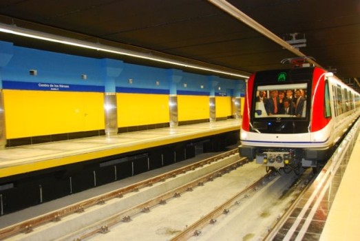
 The Alstom Metropolis 9000 series on testing status in the Santo Domingo Metro. Centro De Los Heroes
The French firm Alstom supplied a total of 19 Alstom Metropolis 9000 three-car trainsets (57 cars) from its factories in Belgium, France and Spain in a contract worth 92.5 million euros.[7] In January 2011, an order was announced for a further 15 Alstom trainsets for Line 2.[8]
The first train was shipped from Barcelona in December 2007 and arrived on January 3, 2008. The standard gauge units have air-conditioning, CCTV and passenger information, and can accommodate 617 passengers per trainset.[9] The trains initially consist of three cars, but all stations are being built to accommodate six car trains in anticipation of expected future ridership demands. Seventeen trainsets will normally be in service, with two sets as spares.[10]
Unlike most other rapid transportation systems, the Santo Domingo Metro does not have a third rail and trainsets instead collect their power from an overhead line system.
Station locations
 Map of the Metro
Line 1
Villa Mella to Centro de los Heroes
Line 2
West to east- Mamá Tingó
- Gregorio Urbano Gilbert
- Gregorio Luperón
- José Francisco Peña Gómez
- Hermanas Mirabal
- Máximo Gómez
- Los Taínos
- Pedro Livio Cedeño
- Peña Batlle
- Centro Olímpico Juan Pablo Duarte
- Juan Bosch
- Casandra Damirón
- Joaquín Balaguer
- Amín Abel
- Francisco Alberto Caamaño
- Centro de los Héroes
References
- ^ El Metro redefinirá la dominicanidad, según Diandino Peña
- ^ "Santo Domingo metro enters service". Railway Gazette International. 2009-01-30. http://www.railwaygazette.com/news/single-view/view//santo-domingo-metro-enters-service.html.
- ^ http://www.skyscrapercity.com/showthread.php?t=814746&page=112
- ^ "NOMBRES POLÍTICOS ESTACIONES - Ministro de Madrid dice el Metro de Santo Domingo está a nivel del que funciona en España". La República. 2008-02-25. http://www.listindiario.com/app/article.aspx?id=49414. Retrieved 2008-02-25.
- ^ http://wikimapia.org/9458760/PUENTE-DE-LA-17
- ^ http://wikimapia.org/9458760/PUENTE-DE-LA-17
- ^ "City News". Railway Gazette International. 2006-07-01. http://www.railwaygazette.com/news/single-view/view//city-news-5.html.
- ^ "World rolling stock market January 2011". 2011-01-07. http://www.railwaygazette.com/nc/news/single-view/view/world-rolling-stock-market-january-2011.html. Retrieved 2011-01-07.
- ^ "Santo Domingo metro delivery". Railway Gazette International. 2007-12-18. http://www.railwaygazette.com/news/single-view/view//santo-domingo-metro-delivery.html.
- ^ ALSTOM to deliver Santo Domingo's first metro Retrieved on 2008-01-18
Categories:- Rapid transit in the Dominican Republic
- Santo Domingo
- Underground rapid transit systems


Wikimedia Foundation. 2010.