- California State Route 60
-
State Route 60

Route information Defined by S&HC § 360 Maintained by Caltrans Length: 70 mi[1] (113 km) History: 1964 Major junctions West end: 

 I-5 / I-10 / US 101 in Los Angeles
 I-710 in East Los Angeles
 I-605 in Industry
 SR 57 in Diamond Bar
 SR 71 in Pomona
 I-15 in Ontario
 I-215 in Riverside
East end: I-10 in BeaumontHighway system State highways in California(list • pre-1964)
History • Unconstructed • Deleted • Freeway • Scenic←  SR 59
SR 59SR 61  →
→State Route 60 is a state highway in the U.S. state of California. It runs from Interstate 10 near the Los Angeles River in Los Angeles east to I-10 in Riverside County, with overlaps at State Route 57 and Interstate 215.
Contents
Route description
This route is part of the California Freeway and Expressway System.[2]
Route 60 serves the cities and communities on the eastern side of the Los Angeles metropolitan area and runs along the south side of the San Gabriel Valley. The west terminus of the freeway is at the East Los Angeles Interchange complex. The east terminus is at the junction with the San Bernardino Freeway, Interstate 10 (I-10) in Beaumont. The freeway is known as the Pomona Freeway west of its junction with State Route 91 and Interstate 215 in Riverside. East of this interchange the freeway is known as the Moreno Valley Freeway until its terminus at its junction with Interstate 10. The freeway shares the alignment of the Orange Freeway, State Route 57 for some 2 miles (3.2 km) in Diamond Bar and also shares the alignment of Interstate 215 for about 5 miles (8.0 km) in Riverside. The route takes its number from former U.S. Route 60.
Pomona Freeway
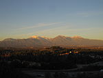 Pomona Freeway in the foreground, with Phillips Ranch, and Mt. San Antonio in the background
The Pomona Freeway is the assigned name Route 60 (SR 60) between its western terminus at the East Los Angeles Interchange complex and its junction with the Riverside Freeway, State Route 91 (SR 91) and Interstate 215 (I-215) in Riverside.
It traverses through Los Angeles, San Bernardino, and Riverside Counties. As it passes through many of Los Angeles' east side suburbs in southern San Gabriel and Pomona Valleys, it is a major transportation corridor. For the majority of its length it is generally parallel to, and south of, the San Bernardino Freeway, Interstate 10 (I-10), and generally parallel to, and north of, the Riverside Freeway, California State Route 91. Traffic congestion is exacerbated by the rapid population growth and, therefore, residential, commercial, and industrial development in the inland communities known informally as the Inland Empire. In particular, it has become increasingly clogged of late with shipping container-laden trucks travelling from the ports of Los Angeles and Long Beach to rail yards and warehouses in the Inland Empire.
Moreno Valley Freeway
The Moreno Valley Freeway is a freeway segment of State Route 60 and Interstate 215, connecting Riverside to communities further east in the Inland Empire and (via Interstate 10) to the Coachella Valley. Its western terminus is at the intersection of the Pomona (State Route 60) and Riverside Freeways (State Route 91 and Interstate 215), near downtown Riverside. The freeway is cosigned as State Route 60 and Interstate 215 for several miles in Riverside, traveling southeast, until the border between Riverside and Moreno Valley, where Interstate 215 branches southward as the Escondido Freeway, and State Route 60 (maintaining the Moreno Valley Freeway designation) branches eastward for approximately 20 miles (32 km). East of Moreno Valley, Route 60 technically loses its freeway status and becomes an expressway (because Caltrans has not yet found the money to close off all driveways and rebuild all at-grade intersections as grade-separated interchanges). After passing through Moreno Valley and the rugged hill country to the east (known as the Badlands to the locals), Route 60 ends at Interstate 10 in Beaumont.
As a result of the rapid development of the Inland Empire since the 1980s, the Moreno Valley Freeway now suffers from severe traffic congestion. The northwestern section that is concurrently signed with Interstate 215 recently underwent significant construction to improve traffic flow.
History
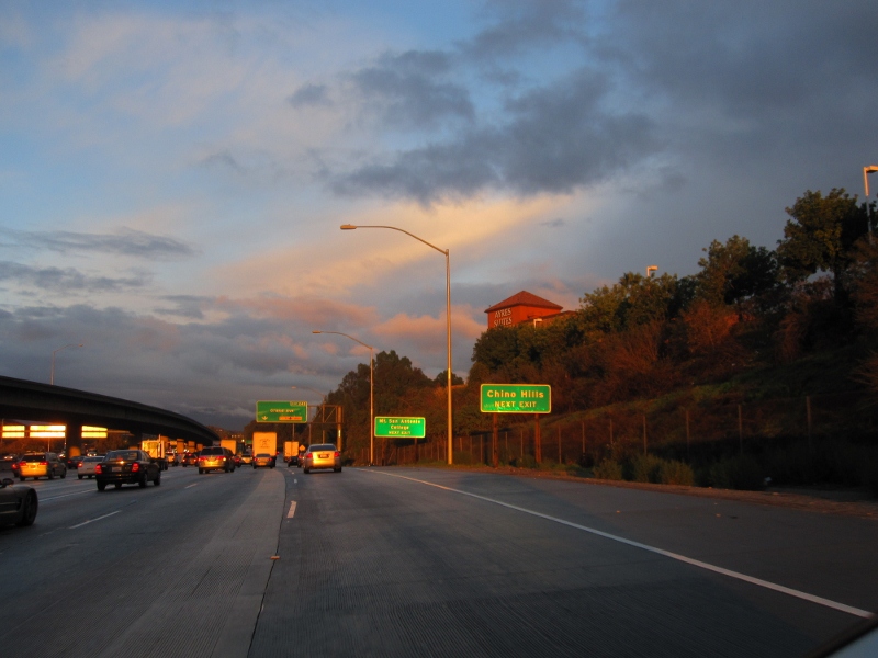
 Pomona Freeway (N) and 57N Interchange, with Grand Ave. exit (exit 24B) for Mt. San Antonio College, Chino Hills, and Diamond Bar visible
Before 1964, U.S. 60 ran from Los Angeles to the Arizona state line, where it continued its nationwide trek, often overlapping U.S. 99 and U.S. 70 along the way. The advent of Interstate 10 created a situation where, at one point, four different signed routes would run along the state-maintained highway.
In 1964, California implemented a plan to simplify its highway-numbering system, where one state highway had only one route number and concurrencies were sternly discouraged. As a result, the U.S. 60 designation (along with U.S. 70 and U.S. 99) was removed. Interstate 10 (as Route 10) superseded U.S. 60's alignment from Beaumont and towards the Arizona state line, even though the routing was only partly a freeway. This left the officially designated Route 60 from Beaumont to Los Angeles orphaned from its original U.S. Highway (which to this day begins at a point on Interstate 10 east of Quartzsite, Arizona). This new Route 60 was provisionally signed as a U.S. Highway since the designation would guide motorists from Los Angeles to Arizona in the absence of a completed freeway for Interstate 10; when all of Route 10 was upgraded to a freeway, the U.S. Highway designation disappeared.
At least one California highway sign managed to be overlooked for many years afterward. A sign on Hess Boulevard at California State Route 62 in the unincorporated town of Morongo Valley pointing not to Interstate 10 but to U.S. 60 (with evidence of the sign having pointed to both U.S. 70 and U.S. 99 as well) stood through the early 2000s. It has since been removed.[3]
The stretch of Route 60 along the Moreno Valley Freeway made national headlines in April, 2004, when five-year-old Ruby Bustamante of Indio and her 26-year-old mother, Norma, were reported missing. Their car had left the road, apparently unwitnessed, between the gap in two guard rails on April 4. It then crashed underneath a tree in a deep ravine. Though Mrs. Bustamante lost her life, presumably at the moment of impact, Ruby survived on her own for ten days on cups of uncooked Top Ramen noodles and bottles of Gatorade which were in the car.
Exit list
- Note: Except where prefixed with a letter, postmiles were measured in 1964, based on the alignment as it existed at that time, and do not necessarily reflect current mileage. The numbers reset at county lines; the start and end postmiles in each county are given in the county column.
County Location Postmile
[4][5][6]Exit
[7][8]Destinations Notes Los Angeles
LA 0.00-R30.46Los Angeles 0.00 1 I-10 west (Santa Monica Freeway) – Santa MonicaWestbound exit and eastbound entrance 0.04 1A Mateo Street, Santa Fe Avenue Westbound exit and eastbound entrance 0.38 1B Soto Street No eastbound exit R0.55 1A I-5 south (Santa Ana Freeway) – Santa AnaEastbound exit and westbound entrance R0.55 1C I-5 north (Golden State Freeway) / US 101 north (Santa Ana Freeway) – Los Angeles, SacramentoWestbound exit and eastbound entrance R1.48 1D Whittier Boulevard, Lorena Street Signed as exit 1B eastbound R1.94 2 Indiana Street Westbound exit and eastbound entrance R2.59 3A Downey Road R3.27 3B I-710 (Long Beach Freeway) – Pasadena, Long BeachMonterey Park R4.43 4 Atlantic Boulevard Montebello R5.16 6A Findlay Avenue Eastbound exit and westbound entrance R5.89 6B Garfield Avenue, Wilcox Avenue Signed as exit 6 westbound R7.77 8 Paramount Boulevard – Montebello Rosemead R8.55 9 San Gabriel Boulevard – Rosemead 9.51 10A  SR 19 (Rosemead Boulevard)
South El Monte 10.23 10B Santa Anita Avenue – South El Monte 11.01 11 Peck Road Industry 11.71 12 I-605 (San Gabriel River Freeway)12.63 13 Crossroads Parkway 14.26 14 Seventh Avenue – Industry Signed as exits 14A (south) and 14B (north) eastbound 15.93 18A Hacienda Boulevard Former SR 39 17.97 18B Azusa Avenue 19.46 19 Fullerton Road 20.43 20 Nogales Street R21.48 21 Fairway Drive – Walnut Diamond Bar R22.97 23 Brea Canyon Road R23.56 24A SR 57 south (Orange Freeway) – Santa AnaWest end of SR 57 overlap R24.45 24B Grand Avenue – Diamond Bar R25.46 25 SR 57 north (Orange Freeway)East end of SR 57 overlap; westbound exit is via exit 26 R25.56 26 Diamond Bar Boulevard Pomona R28.04 28 Phillips Ranch Road R29.39 29A SR 71 (Chino Valley Freeway) – Pomona, CoronaSigned as exit 29B westbound; eastbound exit to SR 71 north is via exit 29B R29.39 29B Garey Avenue Signed as exit 29A westbound R30.33 30 Reservoir Street San Bernardino
R0.00-R9.96Chino R1.37 32 Ramona Avenue R2.37 33 Central Avenue R3.60 34 Mountain Avenue Ontario R4.58 35  SR 83 (Euclid Avenue) – Ontario
R5.86 36 Grove Avenue – Ontario Airport R6.86 37 Vineyard Avenue R7.87 38 Archibald Avenue R8.91 39 Haven Avenue – Ontario Airport R9.96 40 Milliken Avenue, Hamner Avenue Signed as exit 41A westbound; former SR 31 Riverside
R0.00-30.50R0.49 41 I-15 (Ontario Freeway) – Barstow, San DiegoSigned as exit 41B westbound R1.99 42 Van Buren Boulevard, Etiwanda Avenue, Mission Boulevard R3.03 43 Country Village Road, Mission Boulevard (SR 60 Bus. east) R4.55 45 Pedley Road R5.58 46 Pyrite Street Rubidoux 7.53 48 Valley Way, Mission Boulevard (SR 60 Bus.) – Rubidoux 9.56 50 Rubidoux Boulevard – Rubidoux Riverside 11.07 52A Market Street – Downtown Riverside 11.73 52B Main Street R12.06 53A  SR 91 west (Riverside Freeway) – Riverside, Beach Cities
Signed as exit 34B westbound; former US 91 south R12.21
43.27[N 1]53B I-215 north (Riverside Freeway) – San Bernardino, BarstowWest end of I-215 overlap; no exit number westbound; former I-15E north / US 91 north / US 395 north 42.84[N 1] 34A Spruce Street Closed[9] 42.16[N 1] 33 3rd Street, Blaine Street 41.49[N 1] 32 University Avenue (SR 60 Bus. west) 40.98[N 1] 31 Martin Luther King Boulevard 40.28[N 1] 31 El Cerrito Drive Closed[9] 39.48[N 1] 30B Watkins Drive, Central Avenue R38.92[N 1] 30A Fair Isle Drive – Box Springs No westbound exit from I-215 north R38.34[N 1]
R12.2158 I-215 south (Escondido Freeway) – San DiegoEast end of I-215 overlap; no exit number eastbound; former I-15E south / US 395 south 13.31 59 Day Street Moreno Valley 14.32 60 Frederick Street, Pigeon Pass Road (SR 60 Bus. via Sunnymead Boulevard) 15.34 61 Heacock Street 16.35 62 Perris Boulevard 18.37 64 Nason Street 19.20 65 Moreno Beach Drive 20.37 66 Redlands Boulevard – Moreno 21.37 67 Theodore Street 22.10 68 Gilman Springs Road – Hemet, San Jacinto Former SR 177 27.98 74 Jack Rabbit Trail Interchange eastbound; at-grade intersection westbound; no exit number westbound Beaumont Short gap in freeway 30.50 Beaumont Eastbound exit and westbound entrance 30.50 I-10 east – IndioEastbound exit and westbound entrance 1.000 mi = 1.609 km; 1.000 km = 0.621 mi
Concurrency terminus • Closed/Former • Incomplete access • UnopenedSee also
- Interstate 10
- U.S. Route 60
- U.S. Route 70
- U.S. Route 99
References
- ^ January 1, 2006 California Log of Bridges on State Highways
- ^ CA Codes (shc:250-257)
- ^ http://www.westcoastroads.com/california/ca-062.html Link to California 62 article at Westcoastroads. November 2000 photo of the Morongo Valley U.S. 60 sign on Hess Boulevard is near the bottom of the page
- ^ California Department of Transportation, State Truck Route List (XLS file), accessed February 2008
- ^ California Department of Transportation, Log of Bridges on State Highways, July 2007
- ^ California Department of Transportation, All Traffic Volumes on CSHS, 2005 and 2006
- ^ California Department of Transportation, California Numbered Exit Uniform System, State Route 60 Freeway Interchanges, Retrieved on 2009-02-05.
- ^ California Department of Transportation, California Numbered Exit Uniform System, Interstate 215 Freeway Interchanges Northbound and Interstate 215 Freeway Interchanges Southbound, Retrieved on 2009-02-05.
- ^ a b Caltrans District 8: 60-91-215 Interchange Project
External links
- California @ WestCoastRoads.com - State Route 60
- Caltrans: Route 60 highway conditions
- California Highways: Route 60
- The 60/91/215 Freeway Improvement Project
Freeways in Greater Los Angeles Radial Hollywood (US 101/SR 170) • Golden State (I-5) • Antelope Valley (SR 14) • Glendale (SR 2) • Pasadena/Arroyo Seco Pkwy (SR 110) • San Bernardino (I-10) • Pomona (SR 60) • Santa Ana (I-5/US 101) • Laguna (SR 133) • Corona del Mar (SR 73) • Long Beach (I-710) • Seaside (SR 47) • Terminal Island (SR 103) • Harbor (I-110/SR 110) • Marina (SR 90) • Santa Monica (I-10)Circumferential Inland Empire Chino Valley (SR 71) • Foothill (SR 210) • Moreno Valley (SR 60) • Riverside (SR 91) • San Bernardino (I-10/I-215) • I-10 • I-15 • I-215 • SR 259 • SR 330Toll Categories:- Moreno Valley, California
- State highways in California
- Juan Bautista de Anza National Historic Trail
- Southern California freeways
- Roads in Los Angeles County, California
- Roads in San Bernardino County, California
- Roads in Riverside County, California


Wikimedia Foundation. 2010.