- Đeravica
-
Đeravica Gjeravica 
Đeravica.Elevation 2,656 m (8,714 ft) Listing Country high point Pronunciation Serbian: [dʑɛraʋitsa] Location Location of Đeravica (on the Albanian-Kosovo border).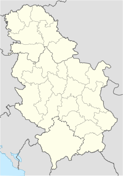
 Đeravica
Location Serbia[a] Range Prokletije Coordinates 42°31′58″N 20°08′27″E / 42.53278°N 20.14083°ECoordinates: 42°31′58″N 20°08′27″E / 42.53278°N 20.14083°E Đeravica Serbian Cyrillic: Ђеравица) is the highest mountain peak located in Kosovo[a] and the second highest in the entire Prokletije and the entire Dinaric Alps chain. It has an altitude of 2,656 m (8,714 ft), although it could be 2,667m as new GPS readings say.[citation needed] Located in south-western Serbia near the Albanian border, it is only surpassed by the Maja Jezercë peak in Albania, which at 2,694 m (8,839 ft) is the highest point of the entire Dinaric Alps.
Between 1992 and 2006 it was the highest mountain peak in the Federal Republic of Yugoslavia, and then in the State Union of Serbia and Montenegro. According to the position of considering Kosovo as part of Serbia sovereign territory, Đeravica is Serbia's highest point also.[1]
It is somewhat different from the rest of the Prokletije mountains because of the lack of a stony, limestone texture the mountains in Prokletije have.[citation needed] Many large and small glacial lakes can be found near the summit. The largest of the lakes is Đeravica Lake which is just under the summit and is the origin of the Erenik river.
Contents
Geography
Nearby settlements
Nearby Peaks
- Kumulore
- Tropojske Pločice
- Guri i Gjate
- Maja e Ram Arućit
- Ljogi i Prelš
Cliffs
- Biga Tamas
- Krši i Ćenit
- Kumulore
- Krši i Zi
- Guri i Mal
- Gurt e Ljove
- Brehov
- Minarja
Nearby Springs
- Kroni Tedel
- Kroni Gusija
- Kroni i Lizit
- Kroni i Nuses
- Gura e Hasanags
- Kroni i Metes
- Gura e Mir
- Kroni i Rasave
- Kroni i Smajlit
- Gura i Ćuršis
- Gura Hođs
- Kroni i Mir
Gallery
-

Glacial lake Đeravica Lake near the summit
-
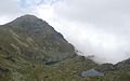
Glacial lakes in Đeravica.
-

Viewpoint from Đeravica
-

Hikers in Đeravica
-

Đeravica is a frequented Hiking place.
-

Another Viewpoint from Đeravica
-

Erenik river near the springs in Đeravica
-

Picture of the lakes
Notes and references
Notes:
a. ^ Kosovo is the subject of a territorial dispute between the Republic of Serbia and the self-proclaimed Republic of Kosovo. The latter declared independence on 17 February 2008, while Serbia claims it as part of its own sovereign territory. Its independence is recognised by 85 UN member states. References:
- ^ Official Web Site of the Serbian Government. Facts about Serbia: Position, Relief, Climate. – Retrieved on 24 December 2008.
External links
Categories:- Mountains of Kosovo
- Prokletije Mountains


Wikimedia Foundation. 2010.