- Colorado River Bridge at Bastrop
-
Colorado River Bridge at Bastrop
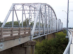

Location: Bastrop, Texas, USA Coordinates: 30°06′35.3″N 97°19′21.4″W / 30.109806°N 97.322611°WCoordinates: 30°06′35.3″N 97°19′21.4″W / 30.109806°N 97.322611°W Built: 1923 Architect: R.E. Schiller Governing body: City of Bastrop NRHP Reference#: 90001031 [1] Added to NRHP: July 19, 1990 The Colorado River Bridge at Bastrop is a 1,285-foot (392 m)-long bridge with three steel truss spans and concrete piers that crosses the Colorado River as part of Loop 150 through Bastrop, Texas. The three bridge spans over the river consist of identical Parker through trusses, each 192 feet (59 m) in length, supported on concrete piers. The bridge is one of the earliest surviving uses of the Parker truss in Texas.
The Colorado River Bridge was the second bridge crossing at this location. The first bridge at the crossing was built from 1889 to 1890 at a cost of $45,000. This bridge replaced the ferries across the river, which had been in use since the 1830s. The bridge was 1,268 feet (386 m) in length. It was originally a toll bridge, but was later purchased by the county and the tolls were removed.
With automobiles becoming the dominant form of transportation in the United States after World War I, a new bridge was needed to handle the increasing traffic between Houston and Austin. The original estimate of the cost of the Colorado River Bridge was $40,000 and was partially financed by bonds issued by Bastrop County. The rest was paid for with federal funds disbursed by the Texas State Highway Department. Bids on the project were solicited and the Kansas City Bridge Co. was selected as contractor. The final cost of the bridge's construction was $167,500. The bridge was completed in 1923 and opened for use in January 1924. The original bridge was sold and torn down in the early 1930s.[2]
Ownership of the Colorado River Bridge probably passed from the county to the state during the depression, as the local governments did not have the funds to maintain their road systems.
Growth in Bastrop in the 1990s strained the capacity of the narrow two-lane bridge. A wider concrete beam bridge was built parallel to the Colorado River Bridge. The State of Texas transferred ownership of the truss bridge to the City of Bastrop and the bridge became a pedestrian walkway. The bridge is also used for special events such as the annual "Art on the Bridge" art show and sale. The bridge was listed in the National Register of Historic Places on July 19, 1990.
See also
- List of Registered Historic Places in Bastrop County
- List of crossings of the Colorado River
References
- ^ "National Register Information System". National Register of Historic Places. National Park Service. 2009-03-13. http://nrhp.focus.nps.gov/natreg/docs/All_Data.html.
- ^ "Colorado River Bridge at Bastrop" Texas Historic Sites Atlas
Crossings of the Colorado River Upstream
Bridge

Colorado River Bridge
Downstream
Bridge

U.S. National Register of Historic Places Topics Lists by states Alabama • Alaska • Arizona • Arkansas • California • Colorado • Connecticut • Delaware • Florida • Georgia • Hawaii • Idaho • Illinois • Indiana • Iowa • Kansas • Kentucky • Louisiana • Maine • Maryland • Massachusetts • Michigan • Minnesota • Mississippi • Missouri • Montana • Nebraska • Nevada • New Hampshire • New Jersey • New Mexico • New York • North Carolina • North Dakota • Ohio • Oklahoma • Oregon • Pennsylvania • Rhode Island • South Carolina • South Dakota • Tennessee • Texas • Utah • Vermont • Virginia • Washington • West Virginia • Wisconsin • WyomingLists by territories Lists by associated states Other Categories:- Buildings and structures in Bastrop County, Texas
- Bridges completed in 1890
- Bridges completed in 1923
- Bridges on the National Register of Historic Places in Texas
- Transportation in Bastrop County, Texas
- Road bridges in Texas


Wikimedia Foundation. 2010.