- Jersey Shore, Pine Creek and Buffalo Railway
-
Jersey Shore, Pine Creek and Buffalo Railway Locale Tioga County, Pennsylvania Dates of operation 1883–1884 Successor Pine Creek Railway Track gauge 4 ft 8 1⁄2 in (1,435 mm) (standard gauge) Headquarters Wellsboro The Jersey Shore, Pine Creek and Buffalo Railway was a railroad built in the early 1880s to give the New York Central and Hudson River Railroad access to the coal regions around Clearfield, Pennsylvania, USA. It was originally planned as part of a connecting line between the East Coast of the United States and Buffalo, New York.
Contents
Reading sponsorship
The railroad was incorporated on February 17, 1870 to run from the vicinity of Williamsport to Jersey Shore, up Pine Creek and down the Allegheny River to Port Allegany,[1] as part of a route to Buffalo.[2]
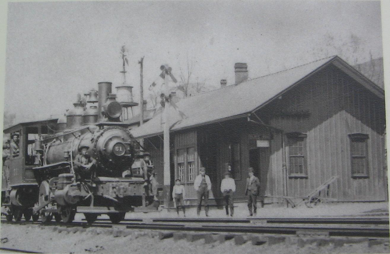
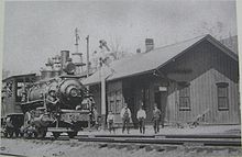 Locomotive and station of the Jersey Shore, Pine Creek and Buffalo Railway
On December 1, 1871, Sobieski Ross, one of the JSPC&B's promoters, wrote to George B. McClellan, extolling the advantages of the route.[3] McClellan was then president of the Atlantic and Great Western Railroad, which shipped petroleum to New York City over the Erie Railway. The Erie's service was felt to be unsatisfactory, and the A&GW potentially interested in a new partner. The eastern end of the A&GW was at Salamanca, New York, about 35 miles (56 km) from Port Allegany along the Allegheny River, and could easily be extended along the river to connect with the JSPC&B. At Newberry, near Williamsport, traffic could be routed onto the Catawissa Railroad and then the Central Railroad of New Jersey to reach the New York area.
Ross's letter gives a good idea of the route planned. He says that it would descend on the western side via Mill Creek,[3] which meets the Allegheny River at Coudersport. The closest approach to the Pine Creek watershed would leave Mill Creek to climb along Nelson Run. A summit tunnel 2,300 feet (700 m) long was planned[3], which would suffice to carry a line from the headwaters of Nelson Run into Splash Dam Hollow, then down Lyman Run to the West Branch Pine Creek, reaching the main stream of Pine Creek at Galeton.
Besides the JSPC&B's value as a trunk line, Ross hopefully anticipated the development of traffic along the line from lumbering, coal mining, and iron manufacturing. In the end, only lumbering and tanning[4] would play a significant role in the industry of the area. The coal beds along the Allegheny River west of Coudersport were proclaimed "worthless" by the State Geological Survey in 1885[5], nor could the local iron ore deposits be economically worked.[6]
While grading of the JSPC&B began on June 12, 1873[2], the Panic of 1873 soon brought a halt to construction. The unfinished line appeared in other grandiose rail schemes: the Gaines and State Line Rail Road, incorporated 1875, would have built north from the JSPC&B at Gaines as part of a line to Hornellsville and Geneva, New York.[7]
The New York Central and coal
During the early 1880s, the New York Central Railroad (NYC) and a consortium of coal companies from Tioga County, Pennsylvania and New York State embarked upon a bold venture. The coal companies were plagued by labor disputes, and the deposits they mined were diminishing. The NYC feared that its rival, the Pennsylvania Railroad, would use its control over coal shipments from central Pennsylvania to inflate the price of that fuel. The solution decided upon was that the coal companies, backed by the NYC, would build a new rail line into the Clearfield Coalfield and open new mines there. Coal would move north over the new line to the NYC. The JSPC&B would be a key link in the new extension.[8] It would also link the NYC to its ally, the Philadelphia and Reading Railroad, via the latter's Catawissa Railroad subsidiary at Newberry.
Gaining control of the JSPC&B, the NYC exploited a provision of the railroad's charter allowing for branches of up to thirty miles in any county traversed by the main line.[3] The new connection would leave the Corning, Cowanesque and Antrim Railroad at Stokesdale Junction, near Wellsboro, and follow Marsh Creek to Pine Creek and the original route at Ansonia, and then pass downstream to Jersey Shore and the Reading connection at Newberry.
The remainder of the grading was sold off, and in fact was the first part of the route to operate: the Coudersport and Port Allegany Railroad opened on the old grade between those two points in 1882. The JSPC&B continued construction on the route from Newberry to Stokesdale Junction, which ran through the spectacular Pine Creek Gorge (also known as the Grand Canyon of Pennsylvania) below Ansonia. The new line began regular service on June 4, 1883 and was opened over its whole length on July 1, 1883.[1][9] However, the New York Central did not choose to operate the JSPC&B directly. On December 18, 1882, it has been leased to the Fall Brook Coal Company from the date of completion, officially June 30, 1883, for twenty years.[9] The company's name was changed to the Pine Creek Railway on June 6, 1884.[1]
Most of the rest of the planned route between Ansonia and Coudersport saw track laid by the Buffalo and Susquehanna Railroad and dependent logging lines.[1] However, it was not connected so as to form a through route, and the summit tunnel was never built.
Pine Creek Railway
Pine Creek Railway Locale Tioga County, Pennsylvania Dates of operation 1884–1909 Successor Geneva, Corning and Southern Railroad Track gauge 4 ft 8 1⁄2 in (1,435 mm) (standard gauge) As the Pine Creek Railway, the new line formed an important part of the Fall Brook's system. The Fall Brook already leased the Corning, Cowanesque & Antrim and a series of NYC-controlled lines in New York, giving it a continuous line from Tioga County to the NYC main line at Lyons, New York. On July 1, 1892, the Fall Brook Coal Company separated its railroad and coal interests, transferring the Pine Creek Ry. lease to the new Fall Brook Railway. However, the independent operation of these lines by the Fall Brook was not to last. In 1895, the NYC began to investigate buying out the Fall Brook, which now formed a vital link between the New York Central main line and the NYC-controlled Beech Creek Railroad at Jersey Shore. The NYC ultimately succeeded in buying up the Fall Brook Railway, and took over the Pine Creek Railway lease on May 1, 1899.[9] On February 4, 1909, the Pine Creek was merged with other elements of the former Fall Brook system to form the Geneva, Corning and Southern Railroad, which in turn was merged into the New York Central on December 22, 1914.[1]
After the 1899 takeover, the former Fall Brook lines were operated by the NYC as the Fall Brook District, Pennsylvania Division.[10] The Pine Creek line was one of those taken over by Conrail in 1976, but the last train ran on the route on October 7, 1988. After the removal of the tracks, the right-of-way was converted to the Pine Creek Rail Trail.[11]
 Former JSPC&B right-of-way along Pine Creek.
References
- ^ a b c d e Taber, Thomas T., III (1987). Railroads of Pennsylvania Encyclopedia and Atlas. Thomas T. Taber III. ISBN 0-9603398-5-X.
- ^ a b Baer, Christopher T. "A General Chronology of the Pennsylvania Railroad Company Predecessors and Successors and its Historical Context". Archived from the original on 2006-09-30. http://web.archive.org/web/20060930032929/http://www.prrths.com/PRR_hagley_intro.htm. Retrieved 2006-11-03.
- ^ a b c d "Letter from Sobieski Ross to George McClellan". http://wnyrails.org/news/c0000043.htm. Retrieved 2006-11-03.
- ^ "Marker Details: Potter County". http://www.explorepahistory.com/hmarker.php?markerId=534. Retrieved 2006-11-03.
- ^ Lesley, J.P. "Potter County". A geological hand atlas of the sixty-seven counties of Pennsylvania: embodying the results of the field work of the survey, from 1874 to 1884. Harrisburg, Pennsylvania: Board of commissioners for the second geological survey, 1885. http://www.libraries.psu.edu/emsl/guides/X/potter.htm. Retrieved 2006-11-03.
- ^ Lesley, J.P. "Lycoming County". A geological hand atlas of the sixty-seven counties of Pennsylvania: embodying the results of the field work of the survey, from 1874 to 1884. Harrisburg, Pennsylvania: Board of commissioners for the second geological survey, 1885. http://www.libraries.psu.edu/emsl/guides/X/lycoming.htm. Retrieved 2006-11-03.
- ^ Map showing the Geneva & Hornellsville Railroad and its connections, New York: G.W. & C.B. Colton & Co., 1875, http://memory.loc.gov/ammem/gmdhtml/rrhtml/rrhome.html, retrieved 2006-11-03
- ^ "Interpreting the Geographies of Peale, Pennsylvania". http://go.owu.edu/~jbkrygie/krygier_html/peale/peale_interp.html. Retrieved 2006-11-03.
- ^ a b c Stoving, Richard L. (2003). Wellsboro's Own Railroad. Hanover, Pennsylvania: The Railroad Press. pp. 21–27. ISBN 1-931477-10-8.
- ^ "The Beech Creek Railroad in the Peale, Pennsylvania Area". http://go.owu.edu/~jbkrygie/krygier_html/peale/peale_bc.html. Retrieved 2006-11-03.
- ^ "Leonard Harrison State Park". http://www.dcnr.state.pa.us/stateparks/parks/leonardharrison.aspx. Retrieved 2006-11-03.
Categories:- Defunct Pennsylvania railroads
- Predecessors of the New York Central Railroad
- Transportation in Tioga County, Pennsylvania
- Railway companies established in 1870
- Railway companies disestablished in 1884

Wikimedia Foundation. 2010.