- Sândominic
-
Sândominic
Csíkszentdomokos— Commune — 

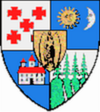
Coat of arms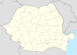
 Sândominic
Csíkszentdomokos Sândominic
CsíkszentdomokosCoordinates: 46°35′0″N 25°47′0″E / 46.583333°N 25.783333°E Country  Romania
County Harghita County Status Commune Government – Mayor Alajos Ferencz (Democratic Union of Hungarians in Romania) Area – Total 158.65 km2 (61.3 sq mi) Population (2002) – Total 6,401 – Density 40.32/km2 (104.4/sq mi) Ethnicity[1] – Hungarians 98,38 – Romanians 0,45% Time zone EET (UTC+2) – Summer (DST) EEST (UTC+3) Postal Code 537275 Area code(s) +40 266 Sândominic (Hungarian: Csíkszentdomokos, Hungarian pronunciation: [ˈtʃiːksɛntdomokoʃ]) is a commune in Harghita County, Romania. It lies in the Székely Land, an ethno-cultural region in eastern Transylvania. It is composed of a single village, Sândominic.
Contents
Demographics
According to the 2002 census, the commune has a population of 6,401, with an absolute Székely Hungarian majority of 6,297 or (98.38%). There are also small minorities of Roma, ethnic Romanians and Germans. [1] [2]
Sândominic is religiously homogeneous, with 98.6% of the population professing Roman Catholicism. Unitarian, Romanian Orthodox, and Hungarian Reformed communities also exist.
The name Sândominic is used for most official purposes, but the population usually uses the shortened form Domokos.
Location
Sândominic is located in the upper reaches of the Olt valley, 29 kilometres north of Miercurea Ciuc. The mountain pass to the northwest, leading to the village of Izvorul Mureşului (Hungarian: Marosfő) and on to the large town of Gheorgheni, marks the northern boundary of the traditional region of Felcsík.
The northern reaches of the village follow the descent of the river Olt to the village centre. Within the village limits, the Lok and Szádakút brooks meet the river, which then flows south to the village of Tomeşti. In 1967, the northern village of Bălan, long a part of the commune but by then more populous than the central village, gained official town status and was separated from Sândominic; however, the two settlements still share important economic and transport links.
The village is served by the Izvorul Olt station of Romanian State Railways, on the Războieni-Târgu Mureş-Deda-Miercurea Ciuc-Sfântu Gheorghe-Braşov line.
History
There is evidence of Székely settlement on the site of Sândominic in the 14th century. In the Middle Ages, the village was the site of iron and copper mining (a tradition carried on until very recently in Bălan.) The name Zent Damokos appears in a document from 1567.[3] The village gained notoriety for an incident of 3 November 1599 at the field of Pásztorbükk. On this day, Székely irregulars, allied in the Long War with Michael the Brave (Romanian: Mihai Viteazul) against the Hungarian nobility, killed the Cardinal András Báthory, Prince of Transylvania, who was retreating to Poland after being defeated in the Battle of Şelimbăr. The murderers were Mihály András Kristály and Balázs Nagy (later nicknamed Balázs Ördög - 'Balázs the Devil') and they were executed for their deed. Pope Clement VIII responded by placing the whole village under interdict. A Memorial Cross was erected in 1816. Its location is at a distance of 5.5 km north of town, on south-eastern slope of the hill Fagul Ciobanului (1108 m)
The village administratively belonged to Csíkszék, then, from 1876 until 1918 to the Csík County of the Kingdom of Hungary. In 1920, Sândominic, like the rest of Transylvania, formally passed with the Treaty of Trianon from Hungarian to Romanian control. The region passed again to Hungary with the 1940 Treaty of the Belvedere (also known as the Second Vienna Award). In 1944, the village was the site of particularly bloody reprisals by Romanian irregulars participating in the recapture of Transylvania from this Hungarian control; a small monument in the village's central square bears witness to the 14 victims, among them an 86-year-old woman. After WWII, it came under Romanian administration and became part of Romania in 1947. Between 1952 and 1960, it formed part of the Hungarian Autonomous Province, then, of the Mureş-Hungarian Autonomous Province until it was abolished in 1968. Since then, the commune is part of Harghita County.
Religious sites and buildings
 Roman Catholic parish church
Sândominic's Roman Catholic church was constructed between 1787 and 1802, and still preserves numerous relics and treasures from the Middle Ages. A Greek Catholic church was completed in 1787, and there is also a small Romanian Orthodox church. Numerous chapels are scattered around the village, including the chapel at Pásztorbükk.
 The location of the commune in Harghita County
A small village museum, containing historic farm equipment, costumes and weaponry, has been installed in the upper floor of the former House of Culture. The lower floor retains its function as a meeting-hall and often hosts musical and theatrical events.
Examples of the famous "Székely gates," richly carved wooden gates often several metres in height, can be seen throughout the village. For this and other reasons, Sândominic has long attracted the attention of ethnologists and anthropologists.
People
- Áron Márton (1896–1980), longstanding Roman Catholic bishop of Alba Iulia and tireless crusader against Romanian Communism. His house in the centre of the village is marked with a commemorative plaque.
- Gyárfás Kurkó (1909–1983), political writer and politician.
External links
- (English) Sândominic (Csíkszentdomokos) on the site of the Harghita County Council.
- (Hungarian) Sândominic (Csíkszentdomokos)library
- (Hungarian) Domokosi Kitekintő ("Domokos Observer" local newspaper
References
- ^ Census data 2002
- ^ Census data
- ^ János András Vistai. "Tekintő – Erdélyi Helynévkönyv". p. 955.Transylvanian Toponym Book
Harghita County, Romania Cities Miercurea-Ciuc (county seat) · Gheorgheni · Italic text Odorheiu Secuiesc · Topliţa
Towns Băile Tuşnad · Bălan · Borsec · Cristuru Secuiesc · Vlăhiţa
Communes Atid · Avrămeşti · Bilbor · Brădeşti · Căpâlniţa · Cârţa · Ciceu · Ciucsângeorgiu · Ciumani · Corbu · Corund · Cozmeni · Dăneşti · Dârjiu · Dealu · Ditrău · Feliceni · Frumoasa · Gălăuţaş · Joseni · Lăzarea · Leliceni · Lueta · Lunca de Jos · Lunca de Sus · Lupeni · Mădăraş · Mărtiniş · Mereşti · Mihăileni · Mugeni · Ocland · Păuleni-Ciuc · Plăieşii de Jos · Porumbeni · Praid · Racu · Remetea · Săcel · Sâncrăieni · Sândominic · Sânmartin · Sânsimion · Sântimbru · Sărmaş · Satu Mare · Secuieni · Siculeni · Şimoneşti · Subcetate · Suseni · Tomeşti · Tulgheş · Tuşnad · Ulieş · Vărşag · Voşlăbeni · Zetea
Categories:- Communes in Harghita County
- Székely communities


Wikimedia Foundation. 2010.