- Denchworth
-
Coordinates: 51°37′23″N 1°27′04″W / 51.623°N 1.451°W
Denchworth 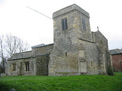
St. James' parish church
 Denchworth
Denchworth shown within OxfordshirePopulation 154 (2001 census)[1] OS grid reference SU3891 Parish Denchworth District Vale of White Horse Shire county Oxfordshire Region South East Country England Sovereign state United Kingdom Post town Abingdon Postcode district OX12 Dialling code 01235 Police Thames Valley Fire Oxfordshire Ambulance South Central EU Parliament South East England UK Parliament Wantage List of places: UK • England • Oxfordshire Drayton is a village and civil parish about 2.5 miles (4 km) north of Wantage. It was part of Berkshire until the 1974 boundary changes transferred the Vale of White Horse to Oxfordshire.
The parish is bounded by the Land Brook in the west and the Childrey Brook in the east. The Great Western Main Line between Reading and Swindon runs through the parish just south of the village, but there is no station.
Contents
History
The Domesday Book of 1086 describes Denchworth as being granted to Henry de Ferrers:
"The same Henry de Ferrers holds Denchworth and Reiner holds of him. Aethelric held it TRE.[2] Then assessed at 7 hides now at five and a half hides. There is land for five ploughs. In demesne is one plough and five villans and five cottars with one plough and 30 acres (12 ha) of meadow and there is a church. TRE it was worth 70 shillings and afterwards 60 shillings. Now 4 pounds."[3]
Denchworth was the home of the old and widespread Berkshire families of Fettiplace and Hyde. The Hydes have many old memorial brasses in the Church of England parish church. One has the commemorative plaque for the foundation of Bisham Priory on the back. There are also stained glass windows by Sir Edward Burne-Jones and it once had a large library of early printed books as well as curiosities such as a "mermaid's rib".
Economy & amenities
 Interior of St. James' parish church
Denchworth has a public house, the Fox Inn,[4] controlled by Greene King Brewery.
RJN Motorsport is based in Denchworth parish.[5]
References
- ^ "Area selected: Vale of White Horse (Non-Metropolitan District)". Neighbourhood Statistics: Full Dataset View. Office for National Statistics. http://neighbourhood.statistics.gov.uk/dissemination/viewFullDataset.do?instanceSelection=03070&productId=779&$ph=60_61&datasetInstanceId=3070&startColumn=1&numberOfColumns=4&containerAreaId=790499. Retrieved 2 January 2011.
- ^ TRE in Latin is Tempore Regis Edwardi, meaning in the time of Edward the Confessor before the Battle of Hastings.
- ^ Domesday Book: A Complete Transliteration, page 148. London: Penguin Books, 2003. ISBN 0-14-143994-7
- ^ The Fox
- ^ RJN Motorsport: Contact Us
Further reading
- Page, W.H.; Ditchfield, P.H., eds (1924). A History of the County of Berkshire, Volume 4. Victoria County History. pp. 280–284.
- Pevsner, Nikolaus (1966). Berkshire. The Buildings of England. Harmondsworth: Penguin Books. pp. 126–127.
External links
Towns 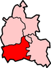
Large Villages Blewbury • Cumnor (Chilswell, Cumnor Hill, Dean Court, Farmoor, Swinford) • Drayton • East Challow • East Hendred • Grove • Harwell • Kennington • Kingston Bagpuize with Southmoor (Kingston Bagpuize, Southmoor) • Marcham (Cothill) • Milton • North Hinksey (Botley, Harcourt Hill) • Radley • St. Helen Without (Dry Sandford, Shippon) • Shrivenham • Stanford in the Vale (Bow) • Steventon • Sunningwell (Bayworth, Boars Hill, Foxcombe Hill) • Sutton Courtenay • Watchfield • Wootton (Boars Hill, Henwood, Lamborough Hill)Other Civil
Parishes
(Component
Villages
and Hamlets)Appleford-on-Thames • Appleton-with-Eaton (Appleton, Eaton) • Ardington (Ardington Wick, West Ginge) • Ashbury (Idstone, Kingstone Winslow) • Baulking • Besselsleigh • Bourton • Buckland (Gainfield) • Buscot • Charney Bassett • Childrey • Chilton • Coleshill • Compton Beauchamp (Knighton) • Denchworth • East Hanney • Eaton Hastings • Fernham • Frilford • Fyfield and Tubney (Fyfield, Tubney, Netherton) • Garford • Goosey • Great Coxwell • Hatford (Little Hatford) • Hinton Waldrist (Duxford) • Kingston Lisle • Letcombe Bassett • Letcombe Regis • Little Coxwell • Littleworth • Lockinge (East Lockinge, West Lockinge) • Longcot • Longworth • Lyford • Pusey • Shellingford • South Hinksey (Hinksey Hill)• Sparsholt • Uffington • Upton • West Challow • West Hanney • West Hendred (East Ginge) • Woolstone • Wytham (Seacourt)Former Districts
and BoroughsMunicipal Borough of Abingdon • Abingdon Rural District • Faringdon Rural District • Wantage Urban District • Wantage Rural DistrictFormer
ConstituenciesCategories:- Villages in Oxfordshire
- Civil parishes in Oxfordshire


Wikimedia Foundation. 2010.