- Oughty Bridge railway station
-
Oughty Bridge 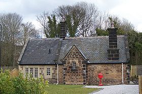
Location Place Oughtibridge Area City of Sheffield Coordinates 53°26′13″N 1°31′55″W / 53.437°N 1.532°WCoordinates: 53°26′13″N 1°31′55″W / 53.437°N 1.532°W Grid reference SK311934 Operations Pre-grouping Sheffield, Ashton-under-Lyne and Manchester Railway
Great Central RailwayPost-grouping London and North Eastern Railway
London Midland Region of British RailwaysPlatforms 2 History 14 July 1845 Opened 15 June 1959 Closed Disused railway stations in the United Kingdom Closed railway stations in Britain
A B C D–F G H–J K–L M–O P–R S T–V W–ZOughty Bridge railway station[1] was a railway station on the Sheffield, Ashton-under-Lyne and Manchester Railway built to serve the village of Oughtibridge, near Sheffield, South Yorkshire.
The station, which lies between Wadsley Bridge and Deepcar was opened on 14 July 1845 and closed on 15 June 1959.[2] The old station house is a grade two listed building constructed from gritstone[3] and has been used for industrial purposes for a number of years. In 2008 it was renovated and converted into a house. When the station was still in use, the goods sidings were used for carrying wood pulp to the nearby paper mill and also freight to and from the Oughtibridge silica works.[4]
Preceding station Disused railways Following station Deepcar British Railways
Great Central Main LineWadsley Bridge References
- ^ The spelling Oughty Bridge was used throughout the life of the station, despite the village name being spelt Oughtibridge. For examples see: Sharpe, John (1855). Sharpe's road-book for the rail, eastern division. London: David Bogue. p. 22. http://books.google.com/books?id=BH8HAAAAQAAJ. and time tables and photographs reproduced in Batty, Stephen R. (2005). Rail Centres: Sheffield. Nottingham: Booklaw Publications. pp. 25, 29, 72, & 75. ISBN 1901945219.
- ^ "Oughty Bridge". Disused Stations. Subterranea Britannica Limited. http://www.subbrit.org.uk/sb-sites/stations/o/oughty_bridge/index.shtml. Retrieved 23 November 2008.
- ^ "Former Oughtibridge Station Building". Images of England. English Heritage. http://www.imagesofengland.org.uk/details/default.aspx?id=335422. Retrieved 23 November 2008.
- ^ A Layman's Look at the History, Industry, People and Places of Oughtibridge ..., Doug Sanderson Page 56. Gives details of listed building and industry
Railways in Sheffield Railway lines █ Dearne Valley · █ Hallam · █ Hope Valley · █ Midland Main Line · █ Penistone · █ Hull · █ Lincoln · █ Wakefield · WoodheadRailway stations Closed stations Attercliffe · Attercliffe Road · Beauchief · Beighton · Bridgehouses · Brightside · Broughton Lane · Chapeltown · Chapeltown Central · Deepcar · Ecclesfield East · Ecclesfield West · Grange Lane · Grimesthorpe Bridge · Heeley · Millhouses · Meadow Hall and Wincobank · Wincobank · Neepsend · Oughtibridge · Tinsley · Victoria · Wadsley Bridge · West Tinsley · WickerEngine sheds Transport in Sheffield · SYPTE
UK railway stations: A B C D E F G H I J K L M N O P Q R S T U V W X Y ZCategories:- Disused railway stations in Sheffield
- Woodhead Line
- Railway stations opened in 1845
- Railway stations closed in 1959
- Grade II listed buildings in Sheffield
- Yorkshire and the Humber railway station stubs

Wikimedia Foundation. 2010.