- Norseman, Western Australia
-
Norseman
Western Australia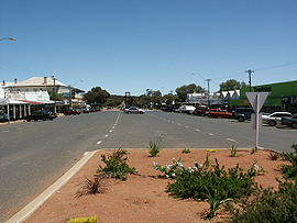
Norseman townsite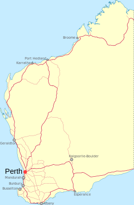
 Norseman
Population: 857 (2006 Census)[1] Postcode: 6443 Coordinates: 32°11′46″S 121°46′41″E / 32.196°S 121.778°ECoordinates: 32°11′46″S 121°46′41″E / 32.196°S 121.778°E Location: - 726 km (451 mi) from Perth
- 196 km (122 mi) from Kalgoorlie
- 203 km (126 mi) from Esperance
LGA: Shire of Dundas State District: Eyre Federal Division: O'Connor Norseman is a town located in the Goldfields-Esperance region of Western Australia along the Coolgardie-Esperance Highway, 726 kilometres (451 mi) east of Perth and 278 metres (912 ft) above sea level. It is also the starting point of the Eyre Highway, and the last major town in Western Australia before the South Australian border 720 kilometres (447 mi) to the east. At the 2006 census, Norseman had a population of 857.[1]
Contents
History
The quest for gold led to the establishment of Norseman. Today there are a number of small goldmining operations in the area but only the Central Norseman Gold Corporation can be considered a major producer. Gold was first found in the Norseman area in 1892 about 10 km south of the town, near Dundas, and the "Dundas Field" was proclaimed in August 1893 and a townsite gazetted there.
In August 1894, Lawrence Sinclair his brother Geroge Sinclair & Jack Alsopp discovered a rich gold reef which Sinclair named after his horse ( Norse-Man )the family originally came from the Shetland Isles in December 1863. Laurie,s brothe James was working in Esperance as the Post & Telegraphist Master. In January 1895, the mining warden asked the Government to declare a townsite for the 200 or so miners who had arrived - it was gazetted on 22 May. The Aboriginal name for the area is "Jimberlana".[2][3]
Norseman initially struggled to develop because of the established town of Dundas, but between 1895 and 1901, a post office, banks, doctor, courthouse, stores and churches were established and in 1899 Cobb & Co mail coaches started delivering mail to Norseman. In 1935, Western Mining Corporation came to Norseman and invested significantly in its infrastructure, resulting in new bitumen roads, electricity and an extension of the Goldfields Water Supply Scheme to the town.[4]
Once it was the second-richest goldfield in Western Australia, next to the Golden Mile of Kalgoorlie. It is claimed that since 1892, over 100 tonnes of gold have been extracted from the area. The Norseman Gold Mine is Australia’s longest continuously running gold mining operation.[5] As of 2006, it had been in operation for more than 65 years, producing in excess of 5.5 million ounces of gold in that time.[6]
Present day
Modern Norseman is a large, sprawling town driven by mining and tourism and dominated by a huge tailings dump.
Norseman is located 724 km east of Perth via Great Eastern Highway and Coolgardie-Esperance Highway, and has a population of about 1,000. It contains a district high school (opened 1894), and ANZ bank, shopping facilities, accommodation (hotel, motel, caravan park), district hospital, council offices and a telecentre are located within the town. Being at the start of the Eyre Highway, three fuel outlets are available.
Geography
Climate
Norseman experiences a desert climate (Köppen climate classification BWh).
Climate data for Norseman, Western Australia (1897-2010) Month Jan Feb Mar Apr May Jun Jul Aug Sep Oct Nov Dec Year Record high °C (°F) 46.0
(114.8)44.9
(112.8)43.8
(110.8)37.0
(98.6)33.3
(91.9)27.8
(82.0)27.7
(81.9)32.5
(90.5)35.6
(96.1)40.0
(104.0)41.1
(106.0)44.9
(112.8)46.0
(114.8)Average high °C (°F) 32.5
(90.5)31.3
(88.3)28.8
(83.8)24.5
(76.1)20.4
(68.7)17.4
(63.3)16.8
(62.2)18.4
(65.1)21.6
(70.9)24.9
(76.8)28.0
(82.4)30.7
(87.3)24.6 Average low °C (°F) 15.8
(60.4)15.9
(60.6)14.5
(58.1)11.6
(52.9)8.5
(47.3)6.3
(43.3)5.2
(41.4)5.4
(41.7)7.4
(45.3)9.7
(49.5)12.2
(54.0)14.0
(57.2)10.5 Record low °C (°F) 6.0
(42.8)6.3
(43.3)3.3
(37.9)0.6
(33.1)−2.3
(27.9)−4.6
(23.7)−3.1
(26.4)−2.2
(28.0)−3
(26.6)−0.7
(30.7)2.2
(36.0)3.6
(38.5)−4.6
(23.7)Precipitation mm (inches) 19.8
(0.78)25.2
(0.992)23.9
(0.941)23.6
(0.929)30.6
(1.205)30.3
(1.193)26.9
(1.059)25.1
(0.988)21.1
(0.831)20.3
(0.799)20.5
(0.807)21.3
(0.839)288.7
(11.366)Source: Australian Bureau of Meteorology[7] See also
References
- ^ a b Australian Bureau of Statistics (25 October 2007). "Norseman (L) (Urban Centre/Locality)". 2006 Census QuickStats. http://www.censusdata.abs.gov.au/ABSNavigation/prenav/LocationSearch?collection=Census&period=2006&areacode=UCL521000&producttype=QuickStats&breadcrumb=PL&action=401. Retrieved 19 July 2011.
- ^ Western Australian Land Information Authority. "History of country town names". http://www.landgate.wa.gov.au/corporate.nsf/web/History+of+country+town+names. Retrieved 2007-04-17.
- ^ Western Australian Government Gazette, file 301/95, 22 May 1895, p.735.
- ^ "Shire of Dundas - History". http://www.dundas.wa.gov.au/tourism/history.html. Retrieved 2006-11-06.
- ^ The Norseman Project Norseman Gold website, accessed: 30 December 2009
- ^ Norseman Gold annual report 2007 accessed: 30 December 2009
- ^ "Climate statistics for Norseman". Australian Bureau of Meteorology. http://www.bom.gov.au/climate/averages/tables/cw_012065_All.shtml. Retrieved 21 September 2011.
External links
Towns in the Goldfields-Esperance region of Western Australia Major centres Kalgoorlie · Boulder · Coolgardie · Esperance · Hopetoun · Kambalda · Kambalda West · Laverton · Leonora · Norseman · Ravensthorpe
Other towns Agnew · Balagundi · Balgarri · Bardoc · Beria · Black Flag · Bonnie Vale · Boorara · Broad Arrow · Buldania · Bullabulling · Bulong · Burbanks · Burtville · Callion · Cascade · Comet Vale · Condingup · Coonana · Cosmo Newbery · Cundeelee · Dalyup · Davyhurst · Duketon · Dundas · Dunnsville · Eucla · Eulaminna · Euro · Feysville · Forrest · Gibson · Gindalbie · Golden Ridge · Goongarrie · Grass Patch · Gudarra · Gwalia · Higginsville · Israelite Bay · Jerdacuttup · Kanowna · Kathleen · Kintore · Kookynie · Kurnalpi · Kunanalling · Kundana · Kurrajong · Kurrawang · Lakewood · Lawlers · Leinster · Linden · Londonderry · Loongana · Malcolm · Menzies · Mertondale · Mount Burges · Mount Ida · Mount Margaret · Mount Morgans · Mulgarrie · Mulwarrie · Mulline · Mungari · Munglinup · Murrin Murrin · Niagara · Ora Banda · Princess Royal · Rawlinna · Salmon Gums · Scaddan · Sir Samuel · Tampa · Vivien · Warburton · Waverley · Widgiemooltha · Windanya · Wingellina · Woodarra · Yarri · Yerilla · Yunndaga · Yundamindera · Zanthus
Towns on the Nullarbor Plain, Australia Western Australia South Australia Categories:- Towns in Western Australia
- Mining towns in Western Australia
- Goldfields-Esperance


Wikimedia Foundation. 2010.