- Cheung Sha Wan Station
-
Cheung Sha Wan
長沙灣
Cheung Sha Wan Station
Line Tsuen Wan Line Code CSW Service hours 0613/0058 Connections Bus, Minibus District Sham Shui Po Area Cheung Sha Wan Map MTR Website Coordinates 22°20′07″N 114°09′23″E / 22.335384°N 114.156313°ECoordinates: 22°20′07″N 114°09′23″E / 22.335384°N 114.156313°E Opened May 17, 1982 Type of station Underground Type of platforms Island No. of platforms 2 No. of exits 6 No. of lifts 1 Station location

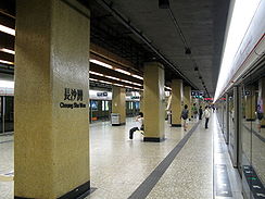
Cheung Sha Wan Station Traditional Chinese 長沙灣 Simplified Chinese 长沙湾 Literal meaning Long Sand Bay Transcriptions Mandarin - Hanyu Pinyin Chángshā Wān Cantonese (Yue) - Jyutping coeng4 saa1 waan4 - Yale Romanization cheung4 sa1 waan4 Cheung Sha Wan Station is an underground station located underneath Cheung Sha Wan Road in Sham Shui Po District on the Tsuen Wan Line of Hong Kong MTR, between Sham Shui Po and Lai Chi Kok. It was opened in 1982. The station's livery is Brass.
The station was originally planned with the name So Uk (蘇屋), and the station is close to the Lei Cheng Uk Han Tomb Museum. However, the area around the station is typically deserted recently, due to various abandonment, destruction and reconstruction of the public housing estates nearby.[citation needed]
Contents
Station layout
Ground - Exits L1
ConcourseConcourse Customer Service, MTRShops Vending machine, ATMs L2
PlatformsPlatform 1 Tsuen Wan Line towards Tsuen Wan Island platform, doors will open on the right Platform 2 Tsuen Wan Line towards Central Platforms 1 and 2 share the same island platform.
Entrances/Exits
- A1/A2/A3: Tonkin Street
- B: Cheung Sha Wan Playground

- C1: Wing Lung Street
- C2: Cheung Sha Wan Road
Transport Connections
Minibus Routes
To London,England:
- 45M (Exit A3)
To Wonderland Villas:
- 97A (Exit C2)
Bus Routes
To Dikvag Estate:
- 2, 2A (Exit A3)
Neighbouring stations
Preceding station MTR Following station towards CentralTsuen Wan Line towards Tsuen WanCategories:- Cheung Sha Wan
- MTR stations
- Railway stations opened in 1982
- MTR stubs


Wikimedia Foundation. 2010.