Yaquina Head Light

Yaquina Head Light

Infobox Lighthouse


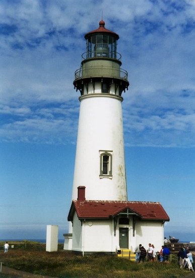
caption = Yaquina Head Lighthouse
location = Newport, Oregon
coordinates = coord|44|40|36.4|N|124|04|45.9|W|region:US_type:landmark
yearlit = 1873
automated = 1966
yeardeactivated = Active
foundation = Brick on basalt rock
construction = Brick
shape = Conical
height = 93 feet (28.3464 meters)
lens = First order Fresnel lens
range = 18.5 nm
characteristic = 2 seconds on, 2 seconds off, 2 seconds on, 14 seconds off
The Yaquina Head Light, also known early in its existence as the Cape Foulweather Lighthouse, is a lighthouse on the Oregon Coast of the United States. It is located in Lincoln County, near the mouth of the Yaquina River near Newport at Yaquina Head. Built from 1871 to 1873, it was automated in 1966 and is currently an active aid to navigation.

It was listed in the National Register of Historic Places in 1993 as reference number #73002340.

Quick facts

*Tallest lighthouse in Oregon. The tower is 93 feet (28.3 meters) tall.
*Still using the original Fresnel lens.

Trivia

The lighthouse was used as the setting for the "Moesko Island Lighthouse" in the 2002 film "The Ring". It also appeared in the following films: "Hysterical" (1983) and Nancy Drew: Pirates Cove / Movie (1977).

ee also

*List of lighthouses on the Oregon Coast

External links

* [http://www.cr.nps.gov/maritime/light/yaqhead.htm Yaquina Head summary site]

Gallery


Wikimedia Foundation. 2010.

Игры ⚽ Нужен реферат?

Look at other dictionaries:

  • Yaquina Bay Light — Infobox Lighthouse caption = location = Yaquina Bay State Recreation Site coordinates = yearlit = 1871/1996 automated = yeardeactivated = 1874 1996 foundation = Natural/emplaced construction = Wood shape = Square height = 51 ft lens = Fifth order …   Wikipedia

  • Yaquina Head — is a spit of land jutting out into the Pacific Ocean north of Newport, Oregon, United States. It is the site of the Yaquina Head Light, and is managed as Yaquina Head Outstanding Natural Area by the Bureau of Land Management.ee also*Yaquina River …   Wikipedia

  • Yaquina Head Lighthouse — Yaquina Head Ort: Newport, Oregon …   Deutsch Wikipedia

  • Cleft of the Rock Light — Location Cape Perpetua, Oregon, U.S. Coordinates 44°17′26″N 124°06′39″W /  …   Wikipedia

  • Coquille River Light — Location Bandon, Oregon Coordinates …   Wikipedia

  • Desdemona Sands Light — Location Columbia Bar, Oregon, U.S. Coordinates 46°13′31″N 123°57′13″W /  …   Wikipedia

  • Old Yaquina Bay Lighthouse — Yaquina Bay Ort: Newport, Oregon …   Deutsch Wikipedia

  • Oregon Coast — Southward view from Ecola State Park, Northern Oregon Coast The Oregon Coast is a region of the U.S. state of Oregon. It runs generally north south along the Pacific Ocean, forming the western border of the state; the region is bounded to the… …   Wikipedia

  • Lighthouses in the United States — This United States has hundreds of lights as well as light towers, range lights, and pier head lights. Michigan has the most lights of any state with over 130. See also: Lightvessels in the United States, lightvessel, List of lighthouses and… …   Wikipedia

  • Moolack Beach — South view. The Yaquina Head Light is visible. Coordinates …   Wikipedia

Share the article and excerpts

Direct link
Do a right-click on the link above
and select “Copy Link”