- Mobile River
-
Contents
Mobile River 
Mobile-Alabama-Coosa River systemOrigin Confluence of Tombigbee and Alabama rivers Mouth Mobile Bay, at Mobile, Alabama Basin countries United States Length 72 km (45 mi) Source elevation 225 m (738 ft) Avg. discharge 67,000 cubic feet per second (1,900 m3/s)
Max: 318,468 cubic feet per second (9,018.0 m3/s) [1]
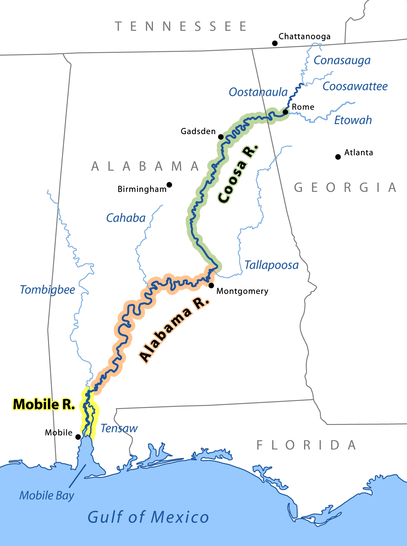
Min: 9,959 cubic feet per second (282.0 m3/s)Basin area 115,000 km² (44,000 mi²) The Mobile River is located in southern Alabama in the United States. Formed out of the confluence of the Tombigbee and Alabama rivers, the approximately 45-mile-long (72 km) river drains an area of 44,000 square miles (110,000 km2) of Alabama, with a watershed extending into Mississippi, Georgia, and Tennessee. Its drainage basin is the fourth-largest of primary stream drainage basins entirely in the United States. The river has historically provided the principal navigational access for Alabama. Since construction of the Tennessee-Tombigbee Waterway, it also provides an alternative route into the Ohio River watershed.
The Tombigbee and Alabama River join to form the Mobile River approximately 50 miles (80 km) north-northeast of Mobile, along the county line between Mobile and Baldwin counties. The combined stream flows south, in a winding course. Approximately 6 miles (10 km) downstream from the confluence, the channel of the river divides, with the Mobile flowing along the western channel. The Tensaw River, a bayou of the Mobile River, flows alongside to the east, separated from 2 to 5 miles (3 to 8 km) as they flow southward. The Mobile River flows through the Mobile-Tensaw River Delta and reaches Mobile Bay on the Gulf of Mexico just east of downtown Mobile.
Biodiversity
The Mobile River Basin historically supported the greatest biodiversity of freshwater snail species in the world (Bogan et al. 1995), including six genera and over 100 species that were endemic to the Mobile River Basin. During the past few decades, publications in the scientific literature have primarily dealt with the apparent decimation of this fauna following the construction of dams within the Mobile River Basin and the inundation of extensive shoal (a shallow place in a body of water) habitats by impounded waters (Goodrich 1944, Athearn 1970, Heard 1970, Stein 1976, Palmer 1986, Garner 1990).[2]
Crossings
This is a list of bridges and other crossings of the Mobile River from Mobile Bay upstream to its source at the confluence of the Tombigbee and Alabama rivers. Proposals for a new bridge to carry Interstate 10 over the river have been debated for several years. Currently the Alabama Department of Transportation is conducting an environmental impact study for such a crossing and into the widening of the Jubilee Parkway, which carries Interstate 10 over Mobile Bay. The location of this bridge is of great debate with some parties pushing for a crossing south of the current tunnels while others are opposed to anything south of the Cochrane–Africatown USA Bridge.
Crossing Carries Location Coordinates George Wallace Tunnel  Interstate 10
Mobile Bankhead Tunnel  U.S. Route 90
 U.S. Route 98
Cochrane–Africatown USA Bridge 
U.S. Route 90
U.S. Route 9814-Mile Bridge CSX General W.K. Wilson Jr. Bridge  Interstate 65
Gallery
 The Mobile River at the Old Fort Stoddert landing, near Mount Vernon, in 2009.
 Aerial view of the Mobile River at its confluence with Chickasaw Creek, about 5 miles (8 km) above Mobile Bay. This photograph was taken about 1990 during construction of the Cochrane-Africatown bridge carrying U.S. Route 90 across the river. The bridge piers and construction crane are visible in the picture.
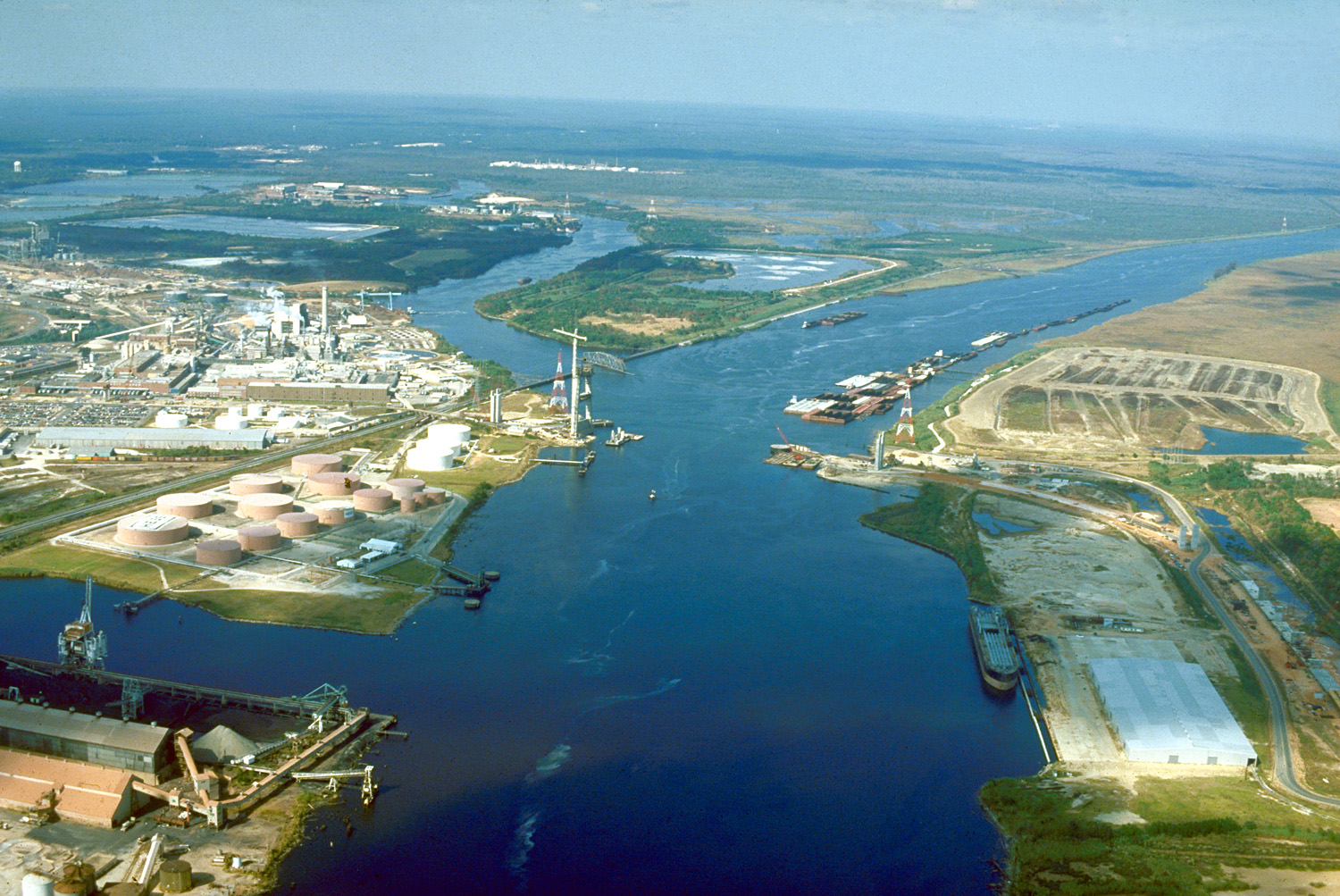
 Map of the Mobile River drainage basin
See also
- Mobile-Tensaw River Delta
- List of Alabama rivers
References
This article incorporates public domain text (a public domainwork of the United States Government) from the reference.[2]
- ^ "River Plume Productivity" (short title), Institute for Marine Remote Sensing (IMaRS), Oceanic Atlas of the Gulf of Mexico, 2001-10-04, web: USF-edu-RPlumeProd.
- ^ a b Fish and Wildlife Service. (October 28) 1998. Endangered and Threatened Wildlife and Plants; Endangered Status for Three Aquatic Snails, and Threatened Status for Three Aquatic Snails in the Mobile River Basin of Alabama. Federal Register, Vol. 63, No. 208, Rules and Regulations, Accessed 26 January 2009.
External links
Categories:- Mobile River
- Geography of Mobile County, Alabama
- Geography of Baldwin County, Alabama


Wikimedia Foundation. 2010.