- Clay County, Alabama
-
Clay County, Alabama 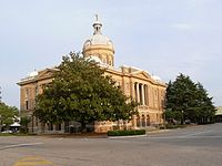 Clay County Courthouse in Ashland
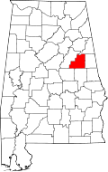
Location in the state of Alabama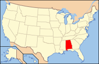
Alabama's location in the U.S.Founded December 7, 1866 Seat Ashland Largest city Lineville Area
- Total
- Land
- Water
606.00 sq mi (1,570 km²)
605.07 sq mi (1,567 km²)
0.93 sq mi (2 km²), (0.15%)Population
- (2010)
- Density
13,932
23/sq mi (8.8/km²)Clay County is a county of the US state of Alabama. Its name is in honor of Henry Clay, famous American statesman, member of the United States Senate from Kentucky and United States Secretary of State in the 19th century. As of 2010 the population was 13,932. Its county seat is Ashland and it is a prohibition or dry county.
Contents
History
Clay County was established on December 7, 1866 from land taken from Randolph and Talladega County. Named after the famous statesman Henry Clay, the county seat itself was named after his estate in Lexington, Kentucky called "Ashland". Clay County was formed for geographic reasons. The citizens of the area had a difficult time reaching the county seat of Wedowee in Randolph County because of the Tallapoosa River to the east. Talladega was difficult to reach because of the intervening mountains. Even today, Clay County is one of only three counties in Alabama to have no U.S. Highways in its boundaries.
During the Desert Shield/Storm conflict, Clay County had more soldiers serving per capita than any other county in the United States.[1]
Geography
According to the 2000 census, the county has a total area of 606.00 square miles (1,569.5 km2), of which 605.07 square miles (1,567.1 km2) (or 99.85%) is land and 0.93 square miles (2.4 km2) (or 0.15%) is water.[2]
Major highways
Rail
Adjacent counties
- Cleburne County, Alabama – north
- Randolph County, Alabama – east
- Tallapoosa County, Alabama – south
- Coosa County, Alabama – southwest
- Talladega County, Alabama – west
National protected area
- Talladega National Forest (part)
Demographics
Clay County, Alabama Year Pop. ±% 1870 9,560 — 1880 12,938 +35.3% 1890 15,765 +21.9% 1900 17,099 +8.5% 1910 21,006 +22.8% 1920 22,645 +7.8% 1930 17,768 −21.5% 1940 16,907 −4.8% 1950 13,929 −17.6% 1960 12,400 −11.0% 1970 12,636 +1.9% 1980 13,703 +8.4% 1990 13,252 −3.3% 2000 14,254 +7.6% 2010 13,932 −2.3% Sources: "American FactFinder". United States Census Bureau. http://factfinder2.census.gov/faces/nav/jsf/pages/index.xhtml. through 1960 As of the census[3] of 2000, there were 14,254 people, 5,765 households, and 4,098 families residing in the county. The population density was 24 people per square mile (9/km2). There were 6,612 housing units at an average density of 11 per square mile (4/km2). The racial makeup of the county was 82.62% White, 15.70% Black or African American, 0.32% Native American, 0.10% Asian, 0.02% Pacific Islander, 0.46% from other races, and 0.79% from two or more races. 1.77% of the population were Hispanic or Latino of any race.
There were 5,765 households out of which 30.80% had children under the age of 18 living with them, 56.70% were married couples living together, 10.50% had a female householder with no husband present, and 28.90% were non-families. 26.70% of all households were made up of individuals and 13.10% had someone living alone who was 65 years of age or older. The average household size was 2.43 and the average family size was 2.93.
In the county the population was spread out with 23.80% under the age of 18, 8.00% from 18 to 24, 27.40% from 25 to 44, 24.20% from 45 to 64, and 16.50% who were 65 years of age or older. The median age was 39 years. For every 100 females there were 95.20 males. For every 100 females age 18 and over, there were 91.10 males.
The median income for a household in the county was $27,885, and the median income for a family was $34,033. Males had a median income of $26,118 versus $18,637 for females. The per capita income for the county was $13,785. About 12.90% of families and 17.10% of the population were below the poverty line, including 21.60% of those under age 18 and 19.00% of those age 65 or over.
Cities and towns
Notable natives
- Hugo Black (1886–1971), born in Harlan, served as an associate justice of the U.S. Supreme Court from 1937 until 1971
- LaFayette L. Patterson (1888–1987), born near Delta, served three terms in the U.S. Congress from 1928 to 1933
- Byron Lavoy Cockrell (1935–2007), born in Lineville, rocket scientist and engineer
- Bob Riley (b. 1944), Alabama's 52nd governor, native of Ashland
Places of interest
Clay County is home to parts of Cheaha State Park in the Talladega National Forest and Lake Wedowee on the eastern boundary. Outdoor adventures abound in Clay County and the surrounding area. The Pinhoti Trail system weaves its way through the Talladega National Forest to Mt. Cheaha, the highest point in Alabama. Hikers along the trail may spy some of the local wildlife, including whitetail deer, wild turkey, and the rare bald eagle.
Home of Doc Hilt Trails for Off-Highway Vehicles. On May 5, 2010, Doc Hilt Trails was awarded the distinction of being a "National Recreation Trail." One of only two private motorized parks in the nation to ever be awarded the NRT designation.
See also
- National Register of Historic Places listings in Clay County, Alabama
- Properties on the Alabama Register of Landmarks and Heritage in Clay County, Alabama
References
- ^ Small Town Historic Markers, Alabama Tourism Department, http://www.alabama.travel/homecoming/, retrieved 2011-02-02
- ^ "Census 2000 U.S. Gazetteer Files: Counties". United States Census. http://www.census.gov/tiger/tms/gazetteer/county2k.txt. Retrieved 2011-02-13.
- ^ "American FactFinder". United States Census Bureau. http://factfinder.census.gov. Retrieved 2008-01-31.

Cleburne County Talladega County 
Randolph County  Clay County, Alabama

Coosa County Tallapoosa County Municipalities and communities of Clay County, Alabama City 
Town  State of Alabama
Topics - Index
- History
- Geography
- People
- Delegations
- Government
- Governors
- Lieutenant Governors
- Metropolitan Areas
- Visitor Attractions
- National Historic Landmarks
Regions Metros - Greater Birmingham
- Montgomery Metro Area
- Mobile Metro Area
- Huntsville Metro Area
Larger cities Counties - Autauga
- Baldwin
- Barbour
- Bibb
- Blount
- Bullock
- Butler
- Calhoun
- Chambers
- Cherokee
- Chilton
- Choctaw
- Clarke
- Clay
- Cleburne
- Coffee
- Colbert
- Conecuh
- Coosa
- Covington
- Crenshaw
- Cullman
- Dale
- Dallas
- DeKalb
- Elmore
- Escambia
- Etowah
- Fayette
- Franklin
- Geneva
- Greene
- Hale
- Henry
- Houston
- Jackson
- Jefferson
- Lamar
- Lauderdale
- Lawrence
- Lee
- Limestone
- Lowndes
- Macon
- Madison
- Marengo
- Marion
- Marshall
- Mobile
- Monroe
- Montgomery
- Morgan
- Perry
- Pickens
- Pike
- Randolph
- Russell
- Shelby
- St. Clair
- Sumter
- Talladega
- Tallapoosa
- Tuscaloosa
- Walker
- Washington
- Wilcox
- Winston
Coordinates: 33°16′20″N 85°51′40″W / 33.27222°N 85.86111°W
Categories:- Alabama counties
- Clay County, Alabama
- 1866 establishments


Wikimedia Foundation. 2010.