- Oklahoma State Highway 31
-
State Highway 31
Route information Maintained by ODOT Length: 132.6 mi (213.4 km) Major junctions West end:  SH-48 south of Tupelo
East end: 
 US-59/US-271 north of Panama
Highway system Oklahoma State Highways
Oklahoma turnpike system←  SH-30
SH-30SH-32  →
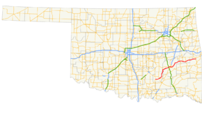
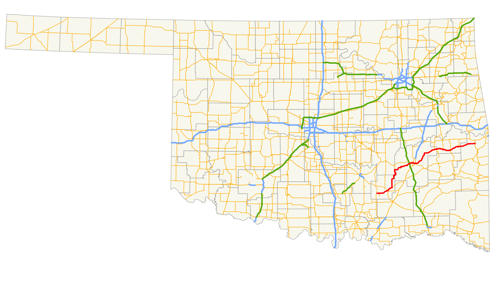
→State Highway 31 (SH-31 or OK-31) is a state highway in Oklahoma. It runs 132.6 miles[1] in an irregular west-to-east pattern in the southeastern part of the state.
There are two spur highways branching from SH-31, SH-31A and SH-31B.
Contents
Route description
SH-31 begins at SH-48 seven miles (11 km) south of Tupelo. Two miles (3.2 km) east of here, SH-31B branches off, connecting the main highway with the town of Olney. SH-31 then continues for 10 miles (16 km) to Coalgate, the seat of Coal County, where it intersects US-75/SH-3. Leaving Coalgate, SH-31 turns north at SH-131, traveling 22 miles (35 km) to its junction with SH-31A, which connects with US-270 at Stuart. At SH-31A, SH-31 turns to the east, following the northern edge of the McAlester Army Ammunition Plant, arriving in McAlester, seat of Pittsburg County, 22 miles (35 km) later.[2]
In McAlester, SH-31 forms a five-mile (8 km) concurrency with US-270 and SH-1, splitting up just east of the US-69 interchange on the east side of the city. SH-31 then sets off to the northeast, passing through Krebs, and crossing the south arm of Lake Eufaula.[2]
At Quinton, 27 miles (43 km) from McAlester, SH-31 serves as the southern terminus of SH-71, then heads east, forming a six-mile (10 km) concurrency with SH-2 to the town of Kinta. At Kinta, SH-2 turns north, and SH-31 continues east, with a short dogleg concurrency with SH-82 at Lequire. Continuing on to the east, SH-31 serves as the southern terminus for SH-26 at McCurtain, then passes though Bokoshe before terminating at US-59/US-271, two miles (3 km) north of Panama.[2]
Junction list
County Location Mile[1] Destinations Notes Coal 0.0 SH-48Western terminus 2.0  SH-31B
Northern terminus of SH-31B Coalgate 11.5 
 US-75 / SH-3
Western end of US-75/SH-3 concurrency 11.6 US-75 / SH-3Eastern end of US-75/SH-3 concurrency Cairo 17.1  SH-131
Western terminus of SH-131 Pittsburg No major junctions Hughes 39.0  SH-31A
Southern terminus of SH-31A Pittsburg McAlester 60.9 
 US-270 / SH-1
Western end of US-270/OK-1 concurrency 62.7  US-69
US-6963.4 US-270 / SH-1Eastern end of US-270/OK-1 concurrency Quinton 90.8  SH-71
SH-71Southern terminus of SH-71 Haskell 92.9  SH-2
SH-2Western end of SH-2 concurrency Kinta 98.6 SH-2Eastern end of SH-2 concurrency Lequire 106.4  SH-82
SH-82McCurtain 115.1  SH-26
SH-26Southern terminus of SH-26 Le Flore 132.6 US-59 / US-271Eastern terminus 1.000 mi = 1.609 km; 1.000 km = 0.621 mi
Concurrency terminus • Closed/Former • Incomplete access • UnopenedSpur routes
- SH-31A is a 5.2-mile (8.4 km) spur connecting SH-31 with US-270 and the town of Stuart in Hughes County.
- SH-31B is a 3.4-mile (5.5 km) spur connecting SH-31 and the town of Olney in Coal County.
External links
References
- ^ a b Stuve, Eric. "OK-31". OKHighways. http://www.okhighways.com/ok31.html. Retrieved 2006-09-19.
- ^ a b c Oklahoma Department of Transportation. Official State Map (Map) (2009–10 ed.). http://www.odot.org/hqdiv/p-r-div/maps/state-maps/2009state/pdfs/state-map.pdf. Retrieved 2010-03-21.
Roads of Fort Smith Interstate Highways 
U.S. Routes Arkansas Highways Oklahoma State Highways Categories:- State highways in Oklahoma


Wikimedia Foundation. 2010.