- M-185 (Michigan highway)
-
M-185
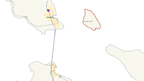
Map of the Straits of Mackinac with M-185 highlighted in redRoute information Maintained by MDOT Length: 8.004 mi[2] (12.881 km) Existed: July 12, 1933[1] – present Major junctions Loop around Mackinac Island Fort Street
British Landing RoadLocation Counties: Mackinac Highway system Michigan State Trunkline Highway System
Interstate • US • State←  M-184
M-184M-186  →
→M-185 is a state trunkline highway in the U.S. state of Michigan that circles Mackinac Island, a popular tourist destination on the Lake Huron side of the Straits of Mackinac, along the island's shoreline. A narrow paved road of 8.004 miles (12.881 km), it offers scenic views of the straits that divide the Upper and the Lower peninsulas of Michigan and Lakes Huron and Michigan. It also has no connection to any other Michigan state trunkline highways—as it is on an island—and is accessible from elsewhere only by passenger ferry. According to the Michigan Department of Transportation (MDOT), M-185 is "the only state highway in the nation where motor vehicles are banned".[3] These restrictions on automobiles date back to the 1890s, and since the ban, only a few vehicles have been permitted on the island other than the city's emergency vehicles.
The City of Mackinac Island, which shares jurisdiction over Mackinac Island with the Mackinac Island State Park Commission (MISPC), calls M-185 Main Street within the built-up area on the island's southeast quadrant, and Lake Shore Road everywhere else. M-185 passes by several key sites within Mackinac Island State Park, including Fort Mackinac, Arch Rock, British Landing, and Devil's Kitchen. Lake Shore Road carries the highway next to the Lake Huron shoreline, running between the water's edge and woods outside of the downtown area. The highway was built during the first decade of the 20th century by the state and designated as a state highway in 1933. The highway was paved in the 1950s, and portions were rebuilt to deal with shoreline erosion in the 1980s. Until 2005, it was the only state highway without any automobile accidents.
Contents
Route description
As a circular highway, M-185 has no specific termini; the generally accepted starting point is at the mile 0 wooden marker placed in front of the Mackinac Island State Park Visitor Center, originally a U.S. Coast Guard station, operated by the MISPC.[4] The highway uses wooden, not metal, markers to measure miles; these signs are erected by the MISPC, as MDOT does not install the standard state highway reassurance markers on this roadway.[5] M-185 is one of only three state trunkline highways in Michigan on islands; the others are M-134 on Drummond Island and M-154 on Harsens Island.[4][6] No part of M-185 has been listed on the National Highway System,[7] a network of roadways important to the country's economy, defense, and mobility.[8] Over a half million people travel along the trunkline in a year, according to an article in The Grand Rapids Press.[9]
Mackinac Island has been a tourist destination since the late 19th century. As the road around the island, M-185 is recognized in the press for its unique role as the only state highway without car traffic in the United States by such papers as The Kansas City Star, [10] the Chicago Tribune,[11] and the Toronto Star.[12] In 2003, it was named the "best scenic drive" in the state by The Detroit News.[13] In 2008, USA Today named the island one of the "10 great places to get your feet back on the ground" as a carfree destination.[14] The magazine Paraplegia News in an article encouraging its readers to visit Mackinac Island called the trek around the island on M-185 a "high priority" for visitors.[15] The trip around the island "provides a photo opportunity at every bend in the path", according to the PSA Journal, the official magazine of the Photographic Society of America.[16]
Along the harbor
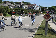 Bikers on M-185 at mile marker 0 in downtown Mackinac Island
The beginning and ending of M-185 is marked at the intersection of Main and Fort streets. At the mile 0 marker in front of the state park visitor center, M-185 heads east between Marquette Park at the base of Fort Mackinac and the marina at Haldimand Bay. The roadway passes the Indian Dormitory (Mackinac Art Center), as well as various hotels, bed and breakfast establishments, private residences and landmarks such as Sainte Anne's Catholic Church, Mission Church and the Mission House. Main Street then turns northeasterly passing Mission Point Resort (the former Mackinac College) to cross onto state park lands, and the road name changes to Lake Shore Road. Along this section of the trunkline, Shoreline Trail departs to the south and follows the water's edge before returning to M-185 at the city's water filtration plant.[4][17][18]
Around the island
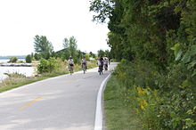
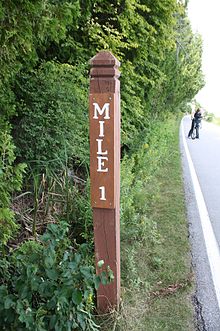
After entering the state park, M-185 continues north-northwesterly along the eastern shore of Mackinac Island, first passing Dwightwood Spring then the Arch Rock viewing area just beyond the mile 1 marker. The next two miles (3.2 km) of M-185 are relatively isolated and devoid of major landmarks as the highway rounds Hennepin Point and runs along Voyageur's Bay. Other than a few picnic tables, the only feature between Arch Rock and mile 3 is the Lake Shore Nature Trail, a short interpretive trail on the inland side of the road. Just beyond mile 3, Scott's Shore Road, a short gravel-surfaced connecting roadway between Lake Shore Road and Scott's Road, departs inland near Point St. Clair. M-185 is bounded by the interior woods on one side and the beaches and rocky shores on the other through this area.[4][17][18]
 Looking south near mile 1
Mile 4 is situated at Point aux Pins at the northernmost point on the island. Here, M-185 and Lake Shore Road turn southerly, passing the state boat dock and the nature center before coming to British Landing at the intersection with British Landing Road. The area is a popular stopping point for tourists biking or walking M-185, and the location where British troops came ashore during the Battle of Mackinac Island during the War of 1812. Located here are restrooms (at the nature center), a water fountain, picnic tables, a concession stand and a stony beach. After a short trip outside the state park boundary along Maniboajo Bay, M-185 and Lake Shore Road re-enter the park at Forest Driveway and continue past the mile 5 marker near Radisson Point before again leaving the park for approximately 1½ miles (2.4 km).[4][17][18]
The next area along M-185 is also sparsely developed as it passes along Griffin Cove. Other than a few newer residential developments, the sights are limited to Brown's Brook, which features a picnic area and interpretive nature trial, and the views of the Mackinac Bridge as the trunkline rounds both Heriot and Perrot points. Between the markers for miles 6 and 7 is the Devil's Kitchen, another popular tourist stopping point, at Jacker Point. Near mile 7 is the West Bluff Stairs leading up the bluff to Pontiac's Lookout. Further along, there is a marker commemorating the filming of a scene from Somewhere in Time as well as views of the Grand Hotel.[4] The building's 660-foot-long (200 m) front porch[19] is billed as the "longest in the world".[20] Visible to the east of the hotel is Michigan's second Governor's Mansion, which is used as a summer retreat for the state's chief executive. At this point, M-185 transitions back to the more developed portion of the island and the road name for the route changes back to Main Street. Next to the roadway, a boardwalk runs from here into the downtown business district.[4][17][18]
Entering downtown
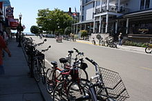 Downtown Mackinac Island near the Star Line Ferry Dock and the Lake View Hotel
The first landmark as the route approaches downtown Mackinac Island is the island's public school building. As it passes the island's public library on the water side of the street, Main Street makes a sweeping curve to the north at Windermere, or Biddle's, Point to run through the downtown district. Other than the library, most of the city's public buildings actually sit along Market Street, one block behind Main Street. M-185 through downtown Mackinac Island passes through the major business district, featuring dozens of shops, restaurants and lodging establishments; many of these outlets, nearly a dozen, feature the authentic Mackinac Island fudge made fresh daily during tourist season. The passenger ferry docks are all situated along Main Street in the downtown area. Three streets and a city park allow for connections between Main and Market streets. At the northeastern end of the downtown district, Main Street intersects Fort Street and the point of beginning for M-185 at the state park visitor center.[4][17][18]
History
The first city ordinances banning all motorized vehicles from the island were passed on July 6, 1898, with similar state park rules coming in 1901.[21] The residents complained after a doctor's car scared their horses and caused carriage accidents, and these complaints prompted the ban.[22] As such, other than a handful of emergency and utility vehicles as well as others by special, limited-time permit, no cars or trucks are allowed on the island and no motorized vehicles appear on M-185. Traffic on this highway is by foot, on horse or by horse-drawn vehicle, or bicycle; M-185 is the only such state highway in the country "that allows no automobiles".[17] As a result, the roadside litter is picked up using a horse-drawn wagon.[23]
Lake Shore Road around the island was built between 1900 and 1910 by the state,[24] and the M-185 designation was first assigned on July 12, 1933.[1] The roadway was purpose-built for non-motorized use; it is narrower than other state highways. During the 1950s, the state paved the road in asphalt.[24] Since the 1970s, the MISPC has allowed snowmobiles to operate on Mackinac Island during the winter.[25]
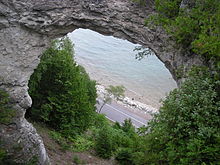 A view of M-185 through Arch Rock
In the mid-1980s, rising water levels in Lake Huron endangered M-185 and bicyclists. The roadway was overwashed by waves from the lake during a storm on May 31, 1985; the waves littered the road with gravel and dirt and raised fears of erosion. MDOT spent around $50,000 to install 2,500 short tons (2,200 long tons; 2,300 t) of rock and filter cloth designed to prevent erosion. The expectation at the time was that Lake Huron could rise another 4–5 inches (10–13 cm) that summer. Such a lake level increase prompted worries that the waves would wash away sections of the road. The lake had already washed away shoreline near Arch Rock; there was at least 8 feet (2.4 m) of berm between the road and shoreline in the 1970s and by 1985 some sections had been reduced to just 2 inches (5.1 cm).[26] Storms in later that year washed away sections of M-185, removing huge chunks of asphalt. MDOT closed the stretches of the roadway on July 7, 1986, after the Independence Day weekend to fix the damage. Repairs were budgeted to cost $894,366 to replace the missing sections of roadway, and tourists were detoured inland, and uphill, to access the island's various tourist attractions.[27]
In 1979, while filming Somewhere in Time, a car was brought on the island for Christopher Reeve's character to drive. The next time that a vehicle was permitted on the island was on July 6, 1998, to commemorate the original ordinance that prohibited cars from Mackinac Island. A 1901 Geneva steam-powered car toured the island and was exhibited in Marquette Park before being towed by horse back to British Landing.[21] The only known motor vehicle collision on Mackinac Island occurred on M-185 at the head of the Shepler passenger ferry dock when the island's fire truck slightly damaged the a door on the island's ambulance on May 13, 2005; both vehicles were responding to a report from the ferryboat that an injured passenger required medical attention.[28] Before this incident, it was the only state highway that "never had an automobile accident" according to the Toronto Star.[29]
Major intersections
 Newer milemarker sign erected along the highway in 2011
The entire highway is on Mackinac Island, Mackinac County. Milemarkers are posted in a counterclockwise fashion.[4]
Mile[2] Destinations Notes 0.000 Fort Street Terminus used for milemarkers 4.552 British Landing Road Leads to interior of the island; British Landing 7.607 Market Street Leads to many signposted historic sites in the downtown area 8.004 Fort Street Terminus used for milemarkers 1.000 mi = 1.609 km; 1.000 km = 0.621 mi See also
 Cycling portal
 Michigan Highways portal
References
- ^ a b Michigan Department of Transportation (February 13, 2001). Right of Way Map, Mackinac County, Sheet 76 (Map). Cartography by V3 Consultants.
- ^ a b Michigan Department of Transportation (2009). MDOT Physical Reference Finder Application (Map). Cartography by Michigan Center for Geographic Information. http://www.mcgi.state.mi.us/prfinder/. Retrieved September 4, 2010.
- ^ Staff (November 3, 2005). "Road & Highway Facts". History and Culture. Michigan Department of Transportation. http://michigan.gov/mdot/0,1607,7-151-9620_11154-129683--,00.html. Retrieved March 17, 2008.
- ^ a b c d e f g h i Mackinac Island Tourism Bureau (2007) (PDF). Tourism Bureau Map of Mackinac Island (Map). Cartography by Christopher J. Bessert. Archived from the original on May 28, 2008. http://web.archive.org/web/20080528033019/http://www.mackinacisland.org/pdfs/mackinacislandlocatormap.pdf. Retrieved June 1, 2009.
- ^ Staff. M-185 Mile 0 Marker (Wooden highway sign). Mackinac Island, MI: Mackinac Island State Park Commission. http://commons.wikimedia.org/wiki/File:Mackinac_Island_July_2010_28_(M-185_mile_marker).JPG. Retrieved July 31, 2010.
- ^ Michigan Department of Transportation (2011). State Transportation Map (Map). 1 in:15 mi / 1 cm:9 km. Cartography by MDOT. Section D10, D12, L14.
- ^ Michigan Department of Transportation (April 23, 2006) (PDF). National Highway System, Michigan (Map). Cartography by MDOT. http://www.michigan.gov/documents/MDOT_NHS_Statewide_150626_7.pdf. Retrieved October 7, 2008.
- ^ Adderly, Kevin (August 26, 2010). "The National Highway System". Planning, Environment, & Realty. Federal Highway Administration. http://www.fhwa.dot.gov/planning/nhs/. Retrieved January 1, 2011.
- ^ DuFresne, Jim (July 13, 2002). "Fort Mackinac the Crown Jewel of Big State Park". The Grand Rapids Press: p. D1.
- ^ Shade, Joanne Prim (August 30, 1992). "Yes, the Water Does Go all the Way Around Mackinac Island You're Welcome To Visit, but Leave the Silly Questions Behind". The Kansas City Star: p. I3.
- ^ Habes, Bob (August 15, 1993). "Mac Attack: 13 Crowd-Beating Ways To Tackle a Special Island". Chicago Tribune: Travel section, p. 1.
- ^ Hanes, Tracy (September 27, 2008). "Mackinac a Pedestrian's Haven". Toronto Star. Archived from the original on November 12, 2011. http://www.thestar.com/article/505311. Retrieved November 8, 2011.
- ^ Staff (April 16, 2003). "Michigan's Best: Recreation". The Detroit News: pp. 28M+.
- ^ Baruffi, Kathy (June 20, 2008). "10 Great Places To Get Your Feet Back on the Ground". USA Today: p. 8D.
- ^ Lichon, Jeff (May 2007). "A Timeless Getaway: Don't Just Imagine What Mackinac Island Is Like—It's Waiting for You To Visit!". Paraplegia News (Phoenix, AZ: Paralyzed Veterans of America) 61 (5): 20. ISSN 0031-1766.
- ^ Vannoy, Dana (May 2003). "Bring a Camera To Experience the 19th Century on Mackinac Island". PSA Journal (Oklahoma City , OK: Photographic Society of America) 69 (5): 30. ISSN 0030-8277.
- ^ a b c d e f Hutchins, Brian (2005). Michigan's West Coast: Explore the Shore Guide. Roscommon, MI: Abri-Press. pp. 172–7. ISBN 0976075490.
- ^ a b c d e Martone, Laura (2010). Michigan's Traverse Bays and Mackinac Island. Moon Spotlight (2nd ed.). Berkeley, CA: Avalon Travel. pp. 61–7. ISBN 9781598809237.
- ^ Staff. "Facts". About Grand Hotel. Grand Hotel. http://grandhotel.com/aboutgrandhotel/facts. Retrieved November 14, 2011.
- ^ Weeks, George (September 18, 2003). "Mackinac Island's Grand Hotel Is History's Front Porch". The Detroit News: p. 1D. Archived from the original on November 9, 2011. http://apps.detnews.com/apps/history/index.php?id=212. Retrieved November 9, 2011.
- ^ a b Mackinac Island State Park Commission (1999). "Early Automobiles on Mackinac Island". A Michigan Auto Tour. Michigan Historical Museum. Archived from the original on November 14, 2011. http://www.hal.state.mi.us/mhc/autoshow/vehicles/mackauto.html. Retrieved November 7, 2011.
- ^ Hunt, Mary; Hunt, Don (2007). "Mackinac Island". Hunts' Guide to Michigan's Upper Peninsula. Albion, MI: Midwestern Guides. http://hunts-upguide.com/mackinac_island.html. Retrieved November 8, 2011.
- ^ Dunnigan, Carol (September 13, 2008). "Joanne Kompsi and 'Billy' Are the Caretakers of M-185". Mackinac Island Town Crier. Archived from the original on November 8, 2011. http://www.mackinacislandnews.com/news/2008-09-13/Columnist/040.html. Retrieved November 8, 2011.
- ^ a b Straus, Frank (August 4, 2007). "Mackinac Island Offers Several Modern Paved Bicycle Trails". Mackinac Island Town Crier. Archived from the original on November 8, 2011. http://www.mackinacislandnews.com/news/2007-08-04/Columnist/034.html. Retrieved November 8, 2011.
- ^ Straus, Frank (February 10, 2007). "Snowmobiles Buzz onto Mackinac Island". Mackinac Island Town Crier. Archived from the original on November 8, 2011. http://www.mackinacislandnews.com/news/2007-02-10/columnist/048.html. Retrieved November 8, 2011.
- ^ Sobota, Michele (June 15, 1985). "State Rescues Island Shore Road Endangered by Rising Lake Levels". Mackinac Island Town Crier.
- ^ Kerwin, James L. (June 26, 1986). "Mackinac Island Isn't Immune to Road Repair Woes". The Detroit News.
- ^ Staff (May 20, 2005). "Cause of Ferry Injuries Under Investigation". Mackinac Island Town Crier. Archived from the original on June 1, 2011. http://www.mackinacislandnews.com/news/2005/0520/News/043.html. Retrieved September 5, 2008.
- ^ Marsh, Betsa (June 3, 2000). "Horsing Around on Mackinac Island". Toronto Star: p. L18.
External links
Categories:- Bike paths in Michigan
- Mackinac Island
- State highways in Michigan
- Transportation in Mackinac County, Michigan


.JPG)
Wikimedia Foundation. 2010.