- Interstate 10 in Texas
-
This article is about the section of Interstate 10 in Texas. For the entire length of the highway, see Interstate 10.
Interstate 10

Route information Maintained by TxDOT Length: 878.6 mi[1] (1,414.0 km) Existed: 1959 – present Major junctions West end:  I-10 at New Mexico state line
 I-20 between Kent and Balmorhea
 I-35 in San Antonio
 I-37 in San Antonio
 I-45 in Houston
East end:  I-10 at Louisiana state line
Highway system Main route of the Interstate Highway System
Main • Auxiliary • BusinessHighways in Texas
Interstate • U.S. • TX (Loops – Spurs – Rec – FM)←  SH 9
SH 9SH 10  →
→Interstate 10 is the major east–west Interstate Highway in the Southern United States. In the U.S. state of Texas, it runs east from El Paso, near the border with New Mexico, through San Antonio and Houston to the border with Louisiana in Orange, Texas.
At just under 879 miles (1,415 km), the stretch of Interstate 10 crossing Texas, maintained by the Texas Department of Transportation, is the longest continuous untolled freeway under a single authority in North America, a title formerly held by Ontario's Highway 401. Mile marker 880 (and the corresponding exit number) near Orange are the highest numbered mile marker and exit on the Interstate Highway System or, for that matter, on any freeway in North America.
Texas alone contains more than a third of the interstate's entire length. El Paso, on the Texas – New Mexico border, is 785 miles (1,263 km) from the western terminus of Interstate 10 in Santa Monica, California, making it closer to Los Angeles than it is to Orange, 857 miles (1,379 km) away. Likewise, Orange, on the Texas–Louisiana border, is only 789 miles (1,270 km) from the eastern terminus of Interstate 10 in Jacksonville, Florida.
Contents
History
West Texas
Interstate 10 replaced and currently runs concurrent with U.S. Highway 85 from the New Mexico border up until the two diverge at mile marker 13. The two highways parallel each other for several miles until Highway 85 continues to head south to the border with Mexico and I-10 turns east towards El Paso. Prior to the interstate system, Highway 85 ran concurrent with U.S. Highway 80 from the New Mexico border until the two diverged west of El Paso. When I-10 was constructed in downtown El Paso, several blocks were demolished, and a sub-grade trench was built for the freeway. A series of overpasses now carry the preexisting north-south surface streets over the east-west stretch of I-10 through downtown. I-10 replaced Highway 80 through El Paso and to the southeast and east to the present day junction of I-10 and Interstate 20. Highway 80 along this route has been completely removed from the highway system in favor of I-10.[2]
At the junction with I-20, I-10 replaced U.S. Highway 290 eastward to the present day junction of I-10 and Highway 290 southeast of Junction. This section of Highway 290 was deleted from the highway system.[3] From this point to near Comfort, I-10 replaced State Highway 27. State Highway 27 still exists along this stretch, mostly paralleling I-10 to the south. From Comfort southeast to San Antonio, I-10 directly replaced U.S. Highway 87.
San Antonio and Central Texas
I-10 generally follows the alignment of US 87 on the northwest side of San Antonio into downtown. A new alignment was built to the south of downtown for the freeway since it was impossible to upgrade the surface streets in downtown that US 87 and US 90 followed prior to the Interstate Highway System. Southeast of downtown, I-10 curves back to the northeast to connect with the pre-interstate alignment of US 90.
Construction of portions of I-10 were well underway and completed prior to the commissioning of the highway in 1959. The section from Culebra Road to Woodlawn Road opened as the first freeway in San Antonio in 1949, but was signed as US 87. Expansion and construction continued in the 1950s, but the bulk of the construction occurred in the 1960s after the interstate was commissioned. The current alignment was completed by 1968.
Rapid growth in San Antonio has resulted in the original highway becoming quickly inadequate, resulting in the highway being in perpetual construction and expansion. In the 1980s the portion just northwest of downtown was reconstructed to add a double deck feature to expand the freeway to five lanes in each direction. In 1990, the interstate had only two lanes in each direction from Loop 1604 to where the double deck freeway begins near downtown. Recent construction has expanded the freeway to five lanes in each direction from just outside the I-410 loop all the way into downtown. The I-10/I-410 interchange was reconstructed into a four-level stack interchange.[4]
Houston and East Texas
 The new I-10 "Katy Freeway" in Houston, with managed lanes (HOV + EzTag). View toward East from connector ramp with West Sam Houston Tollway (Beltway 8)
As part of the construction of Interstate 10 in the 1960s, the Katy Freeway was named for the connection to Katy from Houston. Because West Houston was empty farmland, the freeway was made small and simple for its drivers. Not counting the side lanes, it was only 6-8 lanes wide, which compared to many other freeways in Houston, was tiny. Despite the small size of the freeway at the time, population growth in the area had caused considerable traffic congestion. By 2001, the AADT was 238,000 vehicles just west of the West Loop.[5]
It was not until 2000 that the Katy Freeway was forced to upgrade. It had become inadequate due to the increased traffic and West Houston's bustling communities. In 2002, the old railway immediately north of the freeway had been demolished and the area was cleared for the freeway's renovation.
In 2004, construction began on the freeway. Planned to be at least 16 lanes wide, the new stretch would have to hold up to 200,000 cars per day. Two highway intersections would have to be rebuilt (Beltway 8 and I-610), toll booths would be a new addition, including major landscaping as part of Houston's Highway Beautification Project.
The first completed sections, from just west of Highway 6 to the Fort Bend/Harris county line, opened in late June 2006.[6] As of September 2006, most of the freeway between Beltway 8 and State Highway 6 has been laid, while the stretch to Washington Avenue inside I-610 will be completed later. The completion of the Katy Freeway took place in October, 2008.
Between SH 6 and west I-610, the interior two lanes in each direction are maintained by the Harris County Toll Road Authority as the Katy Freeway Managed Lanes, indicated as the Katy Tollway on overhead signage. Tolls change based on time of day, vehicle occupancy, and axle count. During certain hours, high occupancy vehicles may travel for free.[7]
Route description
West Texas
I-10 enters Texas northwest of El Paso near Anthony and travels southward, concurrent with U.S. Highway 85 and U.S. Highway 180. The US 85 splits off in West El Paso at exit 13 (Sunland Park Drive, Paisano Drive), with US 85 heading south on Paisano Drive, through downtown El Paso, and ending at the Stanton Street Bridge and the border with Mexico via local streets. I-10/US 180 continues turning to the east towards downtown El Paso. I-10 then interchanges with Interstate 110 and US Route 54 (the "Patriot Freeway", or North-South freeway) in a complex, three-level interchange referred to by locals as the "Spaghetti Bowl." I-10 and US 180 diverge east of downtown at Exit 23B (Paisano Drive) as US 180 heads off to the northeast (joining US Route 62 and Paisano Drive northbound) and I-10 to the southeast. I-10's frontage road system is called Desert Boulevard in West El Paso, and Gateway Boulevard in Central and East El Paso. Heading towards Tornillo and Fabens, I-10 turns to the southeast and begins to parallel the Rio Grande and Mexican border for approximately 60 miles (97 km).
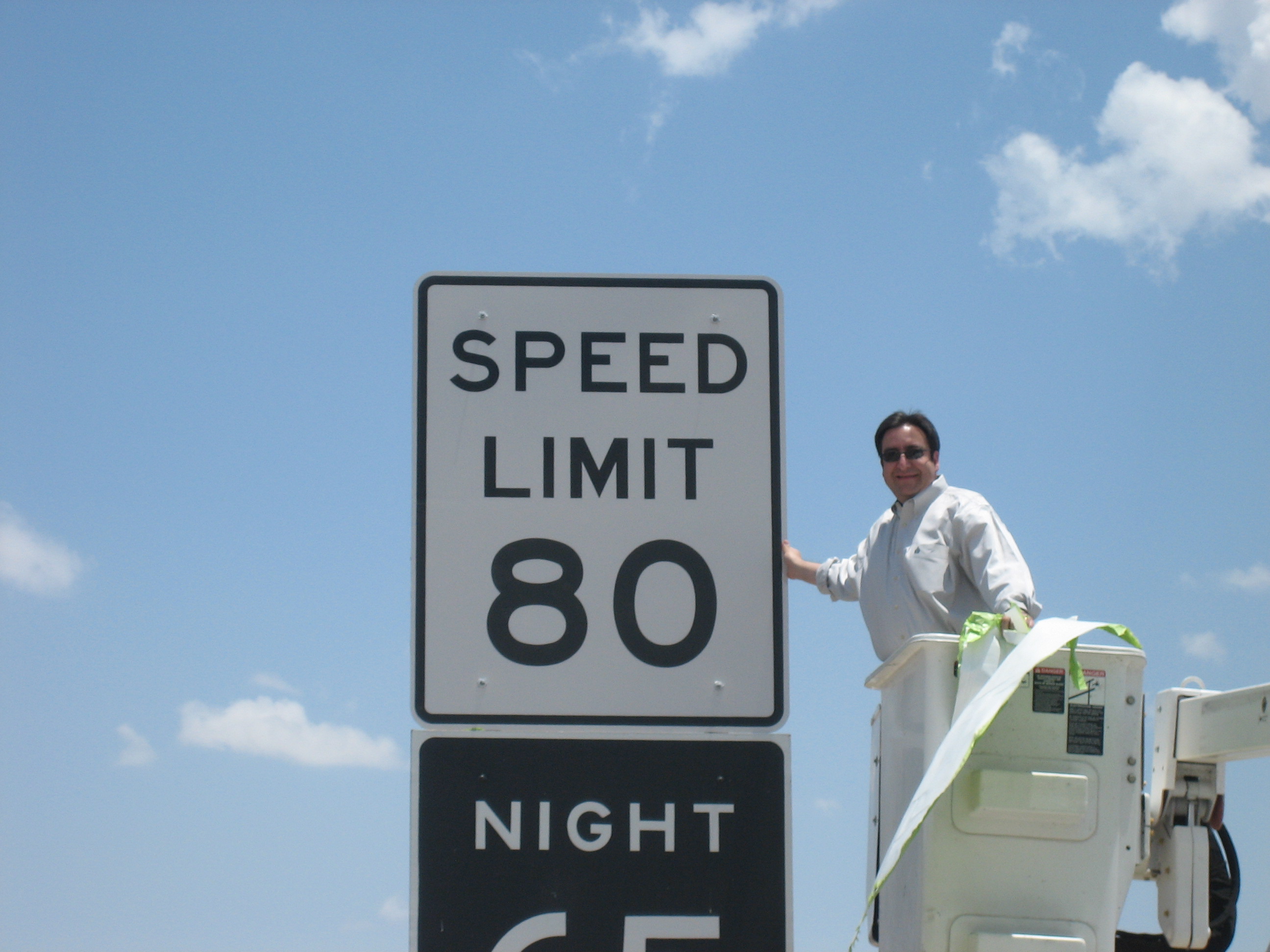
 Texas State Rep. Pete Gallego unveiling a new 80 mph speed limit sign on Interstate 10 near Fort Stockton.
I-10 leaves the Rio Grande with a primarily eastward heading. Just east of Kent, the western terminus of Interstate 20 intersects with I-10. I-20 heads northeast towards the Dallas-Fort Worth area and I-10 continues to head east. US Highway 67 runs concurrently with I-10 for a stretch and the La Entrada al Pacifico trade corridor is a part of this stretch of I-10. Near Junction, I-10 begins a more southeastwardly course as it heads toward the San Antonio metropolitan area. Near Comfort, I-10 and U.S. Highway 87 begin a concurrency that carries on into San Antonio.
Due to I-10 crossing some of the most rural and sparsely inhabited parts of the United States, notably the Trans-Pecos Region it has several unique features that differentiate it from other Interstate Highways. I-10 is one of the very few Interstates that has at-grade intersections (roads that intersect it at a 90 degree angle, as opposed to an overpass or underpass with on and off ramps). These are private access roads (mostly from large ranches) which occur over a limited stretch in western Texas.
The stretch from Kerr County to El Paso County used to have an 80 mph (130 km/h) speed limit but went up to 85 miles per hour on the same stretch, the highest in the nation.
San Antonio and Central Texas
I-10 is the busiest freeway in San Antonio with nearly 200,000 vehicles on an average day.[8] On the northwest side, I-10 is known as the McDermott Freeway, named after Robert F. McDermott, former dean of the United States Air Force Academy as well as CEO of San Antonio-based USAA. The highway enters the city concurrent with US 87 from the north and travels more in a north–south direction into downtown, rather than the east–west designation found on the Interstate Highway signs. The northern section from Loop 1604 to downtown serves one of the fastest growing areas of the city. A majority of the region's suburban office space is located along the corridor as are the headquarters for USAA, gasoline refiner and retailer Valero, South Texas Medical Center, the University of Texas at San Antonio (UTSA), Six Flags Fiesta Texas, and the Shops at La Cantera. I-10 intersects Interstate 410 for the first time near Balcones Heights, a suburban city within San Antonio. The construction of a four-level interchange to accommodate the growing northwest side has been completed. Heavy commercial development dominates the landscape between I-410 and Loop 1604. Inside I-410, the route is lined with light industrial and residential areas.
 I-10 as an elevated freeway as it runs multiplexed with I-35 in downtown San Antonio.
As I-10 heads south into downtown, it splits into an upper level with three lanes in each direction and a lower level with two lanes in each direction. It was necessary to design the freeway this way in order to accommodate the amount of traffic heading into downtown and to fit into the narrow corridor that was surrounded by existing infrastructure. I-10 meets Interstate 35 on the northwest side of downtown and it multiplexes with I-35 South to form the west side of the downtown loop. The I-35 exit numbers are carried through during the multiplex. I-10 and I-35 end their concurrency at a four-level interchange on the southwest side of downtown with the junction of U.S. Highway 90 from the west. I-35 continues to the south and I-10 and US 90 run multiplexed to the east to form the south side of the downtown loop. This section of I-10 is known as the Jose Lopez Freeway, named after the Medal of Honor recipient. A four-level interchange with Interstate 37 occurs approximately 2 miles (3 km) east of the I-35 interchange. I-10 heads east away from downtown through mainly residential neighborhoods on the east side of San Antonio. I-10's multiplex with U.S 87 ends just east of downtown when US 87 heads south towards Victoria. I-10 provides access to the AT&T Center, home of the San Antonio Spurs, and to the Freeman Coliseum. Leaving San Antonio, I-10 again passes the loops I-410 and Loop 1604. I-10 is known as the 90th Infantry Division Memorial Highway on this stretch east of San Antonio. I-10 and US 90 continue their multiplex until they diverge in Seguin. They continue from there on to Houston nearly paralleling each other with short stints of multiplexing along the route.
Houston and East Texas
 I-45 and I-10 near Downtown Houston.
In Houston, from the western suburb of Katy to downtown, I-10 is known as the Katy Freeway. This section was widened in 2008 to as many as 26 total lanes, not counting access road turning lanes[9] and is one of the widest freeways in the world. Between the West Beltway and the West Loop, the minimum lane count for continuous lanes is 22 lanes. In this section, the width is 24 lanes at multiple locations and up to 26 lanes east of Gessner road (12 main lanes, 8 lanes of access roads, and 6 mid-freeway HOT/HOV lanes). From the Fort Bend county line to I-610, there is a minimum of 4 main lanes in each direction.[10]
Between I-610 and I-45 west of downtown, the interstate contains at least 5 mainlanes in each direction. Before 2008, this section had traditionally been the widest section of I-10 in the Houston area and the only one with a significant portion below grade. Starting in 2010, a project was started to widen the freeway, adding one extra mainlane in each direction between Shepherd Drive and Taylor Street.[citation needed] In addition, the eastbound feeder road which ends at Studemont is being extended to Taylor Street.[citation needed] As I-10 travels through downtown, it interchanges with Interstate 45 and U.S. Highway 59, the future corridor of Interstate 69 through Texas. Both interchanges feature left exits causing several lane shifts for through traffic. I-10 provides access to Minute Maid Park, home of the Houston Astros, and also runs through the campus of the University of Houston–Downtown.
The section east of downtown Houston is officially known as the "East Freeway," although it is widely known by locals as the Baytown East Freeway, or colloquially shortened to the Beast, due to a marketing push by Baytown, one of the largest cities in the Greater Houston Area.
In Beaumont, it is designated Eastex Freeway between both splits with U.S. Highway 69. Eastex is not to be confused with the designation for U.S. Highway 59 in Houston.
Business routes
Main article: Business routes of Interstate 10 in TexasI-10 has four business loops within the state. All of these routes are in the far western Trans-Pecos region. These routes are located along the former routes of US 80 and US 290 and include Bus. I-10-C in Sierra Blanca, Bus. I-10-D in Van Horn, Bus. I-10-F in Balmorhea, and Bus. I-10-G in Fort Stockton.
Exit list
County Location # Destinations Notes El Paso Anthony 0  FM 1905 – Anthony
1 Rest Area Eastbound exit and entrance with frontage road access 2 Westway, Vinton El Paso 6  Loop 375 (Trans Mountain Road) – Canutillo
8  SH 178 (Paseo del Norte, Artcraft Road)
9 Redd Road 11  SH 20 (Mesa Street)
12 Resler Drive Westbound exit and eastbound entrance 13  US 85 south (Paisano Drive) / Sunland Park Drive
East end of US 85 overlap 16 Executive Center Boulevard 18A Schuster Avenue – U.T. El Paso 18B Porfirio Diaz Street, Franklin Avenue No westbound entrance 19A SH 20 (Mesa Street) – Downtown El Paso, Convention CenterSigned as exit 19 eastbound. Westbound enter Downtown via Missouri Avenue 19B Downtown El Paso, Convention Center Westbound exit and eastbound entrance 20 Dallas Street, Cotton Street 21 Piedras Street 22A  Loop 478 (Copia Street)
22B 
 US 54 east (Patriot Freeway) / I-110 south – Alamogordo, Fort Bliss, Cd. Juárez
23A Raynolds Street 23B 
 US 62 / US 180 east (Paisano Drive) / Chelsea Street
East end of US 180 overlap 24A Trowbridge Drive Westbound exit is via exit 24 24B Geronimo Drive Signed as exit 24 westbound 25 Airway Boulevard – El Paso Airport 26 Hawkins Boulevard 27 Hunter Drive, Viscount Boulevard Westbound exit is via exit 28A 28A  FM 2316 (McRae Boulevard) / Giles Road
28B Yarbrough Drive, Sumac Drive 29 Lomaland Drive Westbound exit is via exit 30 30 Lee Trevino Drive 32  FM 659 (Zaragosa Road, George Dieter Road)
34 Loop 375 (Americas Avenue, Joe Battle Boulevard)35 Eastlake Boulevard 37  FM 1281 – Horizon City, Socorro
42  FM 1110 – Clint, San Elizario
49  FM 793 – Fabens
55 Tornillo Hudspeth 68 Acala Road 72  Spur 148 – Fort Hancock
78 SH 20 west – McNary81  FM 2217
85 Esperanza Road 87  FM 34
FM 3495 Frontage Road Eastbound exit and entrance 99 Lasca Road Sierra Blanca 105  I-10 Bus. east (El Paso Street)
Signed as exit 106 westbound 107  RM 1111 (Sierra Blanca Avenue)
108 I-10 Bus. west – Sierra BlancaWestbound exit only 129 Allamore, Hot Wells 133 Frontage Road Westbound exit and entrance Culberson Van Horn 138 I-10 Bus. east / Golf Course Drive140A 
 US 90 / SH 54 (Van Horn Drive)
140B I-10 Bus. west (Ross Drive)146 Wild Horse Road 153 Michigan Flat 159 Plateau 166 Boracho Station 173 Hurds Draw Road 176 
 SH 118 / RM 2424 – Kent, Fort Davis
Jeff Davis 181 Cherry Creek Road 184 Springhills Reeves 187 I-20 east – Fort Worth, DallasNo exit number eastbound; exit 186 westbound is a U-turn for I-20 west to I-10 east traffic 188 Giffin Road 192  FM 3078 east – Toyahvale
206  I-10 Bus. east / FM 2903 – Toyah, Balmorhea
209  I-10 Bus. west / SH 17 south – Balmorhea, Fort Davis
West end of SH 17 overlap 212  SH 17 / FM 2448 – Pecos
East end of SH 17 overlap 214 FM 2448Westbound exit and eastbound entrance 222 Hoefs Road Pecos 229 Hovey Road 235 Mendel Road 241 Kennedy Road 246 Firestone Road 248 
 US 67 south / FM 1776 – Alpine, Sul Ross State University
West end of US 67 overlap 253  FM 2037
Fort Stockton 256 I-10 Bus. east – Fort Stockton257  US 285 – Pecos, Sanderson
No westbound entrance 259B  SH 18 – Monahans
Signed as exit 259 eastbound 259A  FM 1053
Eastbound exit is via exit 259 261  I-10 Bus. west / US 385 south – Fort Stockton, Marathon
West end of US 385 overlap 264 Warnock Road 272 University Road 273 US 67 north / US 385 north – San Angelo, McCameyEast end of US 67 / US 385 overlap; no eastbound entrance 277  RM 2023
285 McKenzie Road 288 Ligon Road 294  FM 11 – Bakersfield
298  RM 2886
307 
 US 190 to FM 305 – Iraan, McCamey
314 Frontage Road 320 Frontage Road 325 
 SH 290 / SH 349 – Iraan, Sheffield
Crockett 328 River Road 337 Live Oak Road 343 SH 290 west – Sheffield350  RM 2398 (Howard Draw Road)
361  RM 2083 (Pandale Road)
Ozona 363  Loop 466 / RM 2398 – Ozona
365  SH 163 – Sterling City, Comstock
368 Loop 466 – Ozona372 Taylor Box Road Sutton 381  RM 1312
Eastbound exit and westbound entrance 388 RM 1312Westbound exit and eastbound entrance 392  RM 1312 / RM 1989 (Caverns of Sonora Road)
Sonora 399  Loop 467 – Sonora
Eastbound exit and westbound entrance 400  US 277 – San Angelo, Del Rio
404 
 Loop 467 / RM 864 / RM 3130 – Sonora, Fort McKavett
412 RM 3130 / Allison Road420 RM 3130 / Baker Road429 RM 3130 / Harrell RoadKimble 437  Loop 291 – Roosevelt
Eastbound exit and westbound entrance 438 Loop 291 – RooseveltWestbound exit and eastbound entrance 442  Loop 291 / RM 1674 – Fort McKavett
445 RM 1674Eastbound exit and westbound entrance 451  RM 2291 (Cleo Road)
Junction 456 

 US 83 north / US 377 / Loop 481 – Junction, Menard, Mason
West end of US 83 overlap 457  FM 2169 (Martinez Street) – Junction
460 Loop 481Westbound exit and eastbound entrance 462 US 83 south – UvaldeEast end of US 83 overlap 465 FM 2169 – Segovia472  RM 479 / FM 2169 / Old Segovia Road
477  US 290 east – Fredericksburg
Kerr 484 Midway Road 488  SH 27 – Mountain Home, Ingram
490  SH 41 – Mountain Home, Rocksprings
492 RM 479501  FM 1338
505  RM 783 – Harper, Kerrville
Kerrville 508  SH 16 – Kerrville
520  FM 1341
Kendall Comfort 523 

 US 87 north / US 87 Bus. south – San Angelo, Comfort, Fredericksburg
West end of US 87 overlap 524
 US 87 Bus. north / FM 1621 – Comfort, Waring
527  FM 1621 / FM 289 – Waring
Eastbound exit is via exit 524 533 FM 289 – WelfareBoerne 537
US 87 Bus. south – Boerne538 Ranger Creek Road Westbound exit and eastbound entrance 539 Johns Road 540  SH 46 – New Braunfels, Bandera
542
US 87 Bus. north – BoerneWestbound exit and eastbound entrance 543 Boerne Stage Road, Cascade Caverns Road Bexar 546 Fair Oaks Parkway, Tarpon Drive San Antonio 550  RM 3351 (Ralph Fair Road)
551 Boerne Stage Road – Leon Springs Eastbound exit is via exit 550 552 Dominion Drive Westbound exit and entrance 554 Camp Bullis Road 555 La Cantera Parkway – Fiesta Texas 556A  Loop 1604 (Anderson Loop)
556B Frontage Road 557  Spur 53 (UTSA Boulevard) – University of Texas at San Antonio
558 De Zavala Road 559  Loop 345 south (Fredericksburg Road)
Eastbound exit and westbound entrance 559 Woodstone Drive No eastbound exit 560A Huebner Road Westbound exit is via exit 560 560B Frontage Road Eastbound exit and entrance 560 Ramsgate Drive Westbound exit and entrance 561 Wurzbach Road 562 Medical Drive Westbound exit is via exit 561 562- 563 Callaghan Road Eastbound exit is via exit 562; westbound exit is via exit 563 564  I-410 (Conally Loop)
565A Crossroads Boulevard – Balcones Heights 565B Vance Jackson Road 566A West Avenue 566B Fresno Drive 566C Hildebrand Avenue, Fulton Avenue Signed as exit 567A westbound 567 Loop 345 north (Fredericksburg Road) / Woodlawn AvenueSigned as exit 567B westbound; westbound exit via lower level 568A Cincinnati Avenue Westbound exit via lower level and eastbound entrance via lower level 568B  Spur 421 (Culebra Avenue) / Bandera Road
Signed as exit 568 eastbound; access via upper level 569A Colorado Street Signed as exit 569 westbound; access via lower level; no eastbound entrance 569B Frio Street – Downtown San Antonio Eastbound exit via lower level and entrance via lower level 569C Santa Rosa Street – Downtown San Antonio Eastbound exit via upper level and westbound entrance via upper level 570 I-35 north (Pan Am Expressway) – AustinWest end of I-35 overlap; no exit number westbound (concurrent section uses I-35 exit numbers) 155B Frio Street, Durango Boulevard – Downtown San Antonio 155A  Spur 536 (South Alamo Street)
154B South Laredo Street, Cevallos Street 154A  Loop 353 south (Nogalitos Street) / San Marcos Street US 90 west (Rodriguez Freeway) – Del Rio
West end of US 90 overlap I-35 south (Pan Am Expressway) – LaredoEast end of I-35 overlap 573 To Spur 536 (Roosevelt Avenue) / Probandt Street574  I-37 (Adams Freeway) / US 281 – Corpus Christi, Johnson City
575 Pine Street, Hackberry Street 576 New Braunfels Avenue, Gevers Street 577 US 87 south (Roland Avenue) – VictoriaEast end of US 87 overlap 578 Pecan Valley Drive, M. L. King Drive 579 Houston Street, Commerce Street 580  Loop 13 (W. W. White Road)
581 I-410 (Connally Loop)582 Ackerman Road – Kirby 583 Foster Road 585  FM 1516 – Converse
587 Loop 1604 (Anderson Loop) – Randolph AFB589 Graytown Road, Pfeil Road 591  FM 1518 – Schertz
593  FM 2538 (Trainer Hale Road)
Guadalupe 595 Zuehl Road 597 Santa Clara Road 599  FM 465 – Marion
600 Schwab Road 601  FM 775 – New Berlin, La Vernia
603 
US 90 east to US 90 Alt. – SeguinEast end of US 90 overlap; eastbound exit and westbound entrance 604  FM 725 – Lake McQueeney
605  FM 464
Seguin 607  SH 46 / FM 78 – New Braunfels, Lake McQueeney
609  Bus. SH 123-B (Austin Street)
610  SH 123 – San Marcos, Stockdale
612 US 90 – Seguin617  FM 2438 – Kingsbury
620  FM 1104 – Kingsbury
625 Darst Field Road Luling 628  SH 80 – Nixon, Luling, San Marcos
Caldwell 632  US 183 to US 90 – Gonzales, Cuero, Luling, Lockhart
Gonzales 637  FM 794 – Harwood
642  SH 304 – Bastrop, Gonzales
649  SH 97 – Waelder, Gonzales
653 US 90 – WaelderFayette Flatonia 661 
 SH 95 / FM 609 – Flatonia, Smithville
668  FM 2238 – Engle
Schulenburg 674  US 77 – Schulenburg, La Grange
677 US 90Colorado Weimar 682  FM 155 – Weimar
689 US 90 / Hattermann Lane693  FM 2434 – Glidden
Columbus 695  SH 71 west – La Grange, Austin
West end of SH 71 overlap; eastbound exit is via exit 693 696  SH 71 east / Bus. SH 71-F – Columbus, El Campo
East end of SH 71 overlap 698 US 90 west / Alleyton Road – ColumbusWest end of US 90 overlap 699  FM 102 – Eagle Lake
704  FM 949
709  FM 2761 / Bernardo Road
Austin 713 Beckendorff Road 716 Pyka Road Sealy 718 US 90 eastEast end of US 90 overlap 720  SH 36 – Sealy, Rosenberg, Bellville
720A Outlet Center Drive Eastbound exit only 721 US 90 westWest end of US 90 overlap; westbound exit and eastbound entrance San Felipe 723  FM 1458 – San Felipe, Frydek
725 Mlcak Road Eastbound exit is via exit 723 726 Chew Road Eastbound exit and westbound entrance Waller 729 Peach Ridge Road, Donigan Road (US 90 east) East end of US 90 overlap; signed as exit 730 westbound Brookshire 731  FM 1489 (Koomey Road) – Simonton
732  FM 359 – Brookshire
735 Igloo Road No westbound entrance 737 Pederson Road Fort Bend Katy 740  FM 1463
741 Pin Oak Road Westbound exit is via exit 740 Harris 741 US 90 west / Katy Mills BoulevardWest end of US 90 overlap; westbound exit and eastbound entrance 742 Katy-Fort Bend County Road Eastbound exit is via exit 741 Houston 743  SH 99 (Grand Parkway)
745 Mason Road 746 Westgreen Boulevard 747A Fry Road 747B Greenhouse Road 748 Barker-Cypress Road 750 Park Ten Boulevard 751  SH 6
SH 6753A Eldridge Parkway 753B Dairy Ashford Road 754 Kirkwood Road 755 Wilcrest Drive 756A  Beltway 8 (Frontage Road)
Eastbound exit is via exit 755 756B  Sam Houston Tollway
Signed as exit 756 eastbound 757 Gessner Road 758 Bunker Hill Road 759A Blalock Road, Echo Lane Signed as exit 759 eastbound 759B Campbell Road Eastbound exit is via exit 759 760 Bingle Road, Voss Road 761A Wirt Road, Chimney Rock Road Signed as exit 761 eastbound 761B Antoine Drive, Silber Road Eastbound exit is via exit 761 762 Silber Road, Katy Road, North Post Oak Road Signed as exit 762B westbound 763  I-610 (West Loop Freeway)
764 Washington Avenue, Westcott Street 765A T. C. Jester Boulevard 765B Durham Drive, Shepherd Drive, Patterson Street 766 Yale Street, Heights Boulevard Westbound exit and eastbound entrance 767A Studemont Drive Eastbound exit and westbound entrance 767B Taylor Street 768 I-45 (North Freeway, Gulf Freeway) – Dallas, GalvestonSigned as exits 768A (north) and 768B (south) 769A Smith Street – Downtown Houston Eastbound exit and westbound entrance 769B San Jacinto Street, Main Street Westbound exit and eastbound entrance 769C McKee Street, Hardy Street Eastbound exit and westbound entrance 770  US 59 (Eastex Freeway) – Victoria, Cleveland
Signed as exits 770A (south) and 770C (north) 770B Jensen Drive, Meadow Street, Gregg Street 771A Waco Street 771B Lockwood Drive 772 Kress Street, Lathrop Street 773A
US 90 Alt. west (North Wayside Drive)West end of US 90 Alt. overlap 773B McCarty Drive (US 90 Alt. east) East end of US 90 Alt. overlap 774 Gellhorn Drive Eastbound exit and westbound entrance 775A I-610 (East Connally Loop) / US 90 eastEast end of US 90 overlap 776A Mercury Drive 776B John Ralston Road, Holland Avenue 778A  FM 526 (Federal Road)
Westbound exit is via exit 778 778B Normandy Street Signed as exit 778 westbound 779A Westmont Street Westbound exit only 779B Market Street Road, Uvalde Road Signed as exit 780 eastbound Channelview 780 Freeport Street Eastbound exit is via exit 780 781A Beltway 8 (Frontage Road)Eastbound exit and westbound entrance 781B Beltway 8 (Sam Houston Parkway)Signed as exit 781A westbound 781B Market Street Westbound exit only 782 Dell Dale Avenue No westbound entrance 783 Sheldon Road 784 Cedar Lane, Bayou Drive 785 Magnolia Avenue 786 Monmouth Drive Baytown 787 Crosby-Lynchburg Road 788  Spur 330 east – Baytown
Westbound exit is via exit 787 789 Thompson Road 790 Ellis School Road Westbound exit only 790 Wade Road Westbound exit is via exit 791 791 John Martin Road 792 Garth Road 793 North Main Street 795 Sjolander Road 796 Frontage Road Chambers Mont Belvieu 798  SH 146 – Mont Belvieu, Baytown
Signed as exit 797 eastbound 799 SH 99 (Grand Parkway)800  FM 3180
Cove 803  FM 565 – Cove, Old River-Winfree
Trinity River Boat Ramp, Turnaround 806 Frontage Road Eastbound exit and westbound entrance 807 Wallisville 810  FM 536 – Anahuac, Liberty
811 Turtle Bayou Turnaround Eastbound exit only 813  SH 61 – Hankamer, Anahuac
Signed as exit 812 eastbound 817  FM 1724
819 Jenkins Road 822  FM 1410
Winnie 827  FM 1406
828 
 SH 73 / SH 124 – Winnie, Port Arthur
Eastbound exit and westbound entrance 829  FM 1663
Jefferson 833 Hampshire Road 838  FM 365
843 Smith Road Beaumont 845  FM 364 (Major Drive)
Westbound exit is via exit 847 847 Brooks Road Eastbound exit is via exit 845 848 Walden Road 849 

 US 69 south / US 96 south / US 287 south – Port Arthur
West end of US 69 / US 96 / US 287 overlap 850 Washington Boulevard Eastbound exit is via exit 849 851 US 90 (College Street) – Liberty852A Laurel Avenue Westbound exit and eastbound entrance 852B Calder Avenue, Harrison Avenue, Gladys Avenue 853A US 69 north / US 96 north / US 287 north – Lufkin, JasperEast end of US 69 / US 96 / US 287 overlap 853B 11th Street 853C 7th Street Eastbound exit and westbound entrance 854  Spur 380 (M. L. King Parkway)
855A US 90 west – Downtown BeaumontWest end of US 90 overlap 855B Magnolia Avenue, Pine Street Eastbound exit is via exit 854 Orange 856 Old Highway Eastbound exit and westbound entrance Rose City 858 Asher Turnaround – Rose City 859 DeWitt Road, Bonner Turnaround, Asher Turnaround Vidor 860A North Dewitt Road Westbound exit and eastbound entrance 860B West Vidor Westbound exit and eastbound entrance 861A  FM 105 – Vidor
861B Lamar Street Westbound exit only 861C Denver Street Eastbound exit and westbound entrance 861D  SH 12 – Deweyville, Mauriceville
No eastbound entrance 862A Railroad Avenue Eastbound exit and westbound entrance 862B Old Highway Westbound exit and eastbound entrance 862C Timberlane Drive Eastbound exit and westbound entrance 864 
 FM 1132 / FM 1135
865 Doty Road Westbound exit and eastbound entrance 867 Frontage Road Eastbound exit only 869  FM 1442 – Bridge City
870  FM 1136
Westbound exit and eastbound entrance Orange 873  SH 62 / SH 73 – Bridge City, Port Arthur
874A
US 90 Bus. east PinehurstEastbound exit and westbound entrance 874B Womack Road Westbound exit and eastbound entrance 875  FM 3247 (M. L. King Jr. Drive)
876 Frontage Road – Adams Bayou 877  SH 87 – Newton, Orange
878
US 90 Bus. west (Simmons Drive)879 Texas Travel Information Center Eastbound exit is via exit 880 880 Sabine River Turnaround Eastbound exit and westbound entrance 1.000 mi = 1.609 km; 1.000 km = 0.621 mi Reference
- ^ Texas Department of Transportation. "Highway Designation File - Interstate Highway 10". http://www.dot.state.tx.us/tpp/hwy/ih/ih0010.htm. Retrieved 2006-09-21.
- ^ Texas Department of Transportation, Highway Designation File - U.S. Highway 80
- ^ Texas Department of Transportation, Highway Designation File - U.S. Highway 290
- ^ History of the San Antonio Area Freeway System
- ^ 24 Hour Saturation Counts. H-GAC Transportation Department. Last accessed September 20, 2006.
- ^ Governor Perry and Rep. Culberson Join TxDOT for Katy Frwy Ribbon Cutting. Katy Freeway Public Information Office. June 26, 2006. Last accessed September 20, 2006.
- ^ "Toll Road Info". Harris County Toll Road Authority. https://www.hctra.org/tollroads/. Retrieved 2010-10-02.
- ^ Texas Department of Transportation, 2004 San Antonio District Traffic Map
- ^ Texas Department of Transportation, Schematic Layout: IH 10 Katy Frwy, IH 10 at Bunker Hill Road
- ^ http://www.katyfreeway.net/schematics.html
External links
Interstate 10Previous state:
New MexicoTexas Next state:
LouisianaSan Antonio area freeways Radial Pan Am Expressway (I-35) • Rodriguez Freeway (US 90) • Stotzer Freeway (SH 151) • McDermott Freeway/Jose Lopez Freeway (I-10) • McAllister Freeway/San Pedro Avenue (US 281) • Adams Freeway/Bordelon Freeway (I-37) • Poteet-Jourdanton Freeway (Spur 422)Belt Other limited-access roads General Hudnell Drive (Spur 371) • Kelly Parkway (proposed)Highways in Houston–Sugar Land–Baytown Radial South Freeway (SH 288) · Fort Bend Parkway (SH 122) · Southwest Freeway (US 59) · Spur 527 · Westpark Tollway · Katy Freeway (I-10) · Northwest Freeway (US 290) · Tomball Parkway (SH 249) · North Freeway (I-45) · Hardy Toll Road · Eastex Freeway (US 59) · Crosby Freeway (US 90) · Baytown East Freeway (I-10) · Decker Drive (Spur 330) · La Porte Freeway (SH 225) · Lowry Expressway (FM 1764) · Gulf Freeway (I-45) · Spur 5 (SH 35)
Belt Other limited-access roads El Paso County highways Interstates I-10 (Desert Boulevard) • I-110
U.S. Highways US 54 (Patriot Freeway) • US 62 (Paisano Drive/Montana Avenue) • US 85 (Paisano Drive) • US 180 (Montana Avenue)
Bannered U.S. Highways Bus. US 54-A (Dyer Street)
State Highways State Loops and Spurs Spur 6 • Spur 37 • Loop 375 (Cesar Chavez Memorial Highway) • Loop 478 (Dyer Street) • Spur 601
Park and Recreational Roads PR 68
Farm and Ranch to Market Roads FM 76 (North Loop Drive) • FM 258 (Socorro Road) • FM 259 • FM 659 (Zaragoza Road) • FM 796 • FM 1110 (Mission Trail) • FM 1281 (Horizon Boulevard) • FM 1505 • FM 1905 (Antonio Street) • FM 2316 (McRae Boulevard) • FM 2529 (McCombs Street) • FM 2637 • RM 2775 (Hueco Tanks Road) • FM 3255 (Martin Luther King Jr. Boulevard)
Hudspeth County highways Interstates I-10
Interstate Business Routes Bus. I-10-C
U.S. Highways US 62 • US 180
State Highways State Loops and Spurs Spur 148
Farm and Ranch to Market Roads FM 34 • FM 192 • FM 1088 • RM 1111 • FM 1437 • FM 1576 • FM 2217 • FM 2249 • RM 2317
Culberson County highways Interstates I-10
Interstate Business Routes Bus. I-10-D
U.S. Highways US 62 • US 90 • US 180 • US 285
State Highways Farm and Ranch to Market Roads RM 652 • RM 1108 • RM 1165 • FM 1523 • FM 2017 • FM 2119 • FM 2185 • RM 2424 • FM 2809 • FM 3541
Jeff Davis County highways Interstates I-10
U.S. Highways US 90
State Highways State Loops and Spurs Spur 77 • Spur 78
Park and Recreational Roads PR 3 • PR 3A
Farm and Ranch to Market Roads RM 505 • RM 1832 • RM 1837 • FM 2017 • FM 3078
Reeves County highways Interstates I-10 • I-20
Interstate Business Routes Bus. I-10-F • Bus. I-20-B
U.S. Highways US 285
State Highways Park and Recreational Roads PR 30
Farm and Ranch to Market Roads RM 652 • FM 761 • FM 869 • FM 1215 • FM 1216 • FM 1450 • FM 1934 • FM 2007 • FM 2119 • FM 2448 • FM 2903 • FM 3078 • FM 3334 • FM 3398
Pecos County highways Interstates I-10
Interstate Business Routes Bus. I-10-G
U.S. Highways US 67 • US 90 • US 190 • US 285 • US 385
State Highways State Loops and Spurs Spur 194 • Loop 293
Farm and Ranch to Market Roads FM 11 • FM 305 • FM 1053 • FM 1450 • FM 1776 • FM 1901 • RM 2023 • FM 2037 • RM 2400 • RM 2593 • RM 2885
Colorado County highways Interstates I-10
U.S. Highways US 90
Bannered U.S. Highways State Highways State Highway Business Routes Bus. SH 71-F
State Loops and Spurs Spur 52
Farm and Ranch to Market Roads FM 102 • FM 109 • FM 155 • FM 333 • FM 532 • FM 806 • FM 949 • FM 950 • FM 1093 • FM 1291 • FM 1693 • FM 1890 • FM 2144 • FM 2434 • FM 2437 • FM 2614 • FM 2761 • FM 2764 • FM 3013
Austin County highways Interstates I-10
U.S. Highways US 90
State Highways State Loops and Spurs Loop 350 • Loop 497
Park and Recreational Roads PR 38
Farm and Ranch to Market Roads Waller County highways Interstates I-10
U.S. Highways US 90 • US 290
Bannered U.S. Highways Bus. US 290-H
State Highways Farm and Ranch to Market Roads Fort Bend County highways Interstates I-10
U.S. Highways US 59 • US 90
Bannered U.S. Highways State Highways State Loops and Spurs Spur 10 • Spur 58 • Spur 529 • Loop 540 • Loop 541
Park and Recreational Roads PR 72
Toll Roads Fort Bend Parkway • Fort Bend Westpark
Farm and Ranch to Market Roads FM 359 • FM 360 • FM 361 • FM 442 • FM 521 • FM 723 • FM 762 • FM 1092 • FM 1093 • FM 1236 • FM 1462 • FM 1463 • FM 1464 • FM 1489 • FM 1640 • FM 1875 • FM 1876 • FM 1952 • FM 1994 • FM 2218 • FM 2234 • FM 2759 • FM 2919 • FM 2977 • FM 3155 • FM 3345
Harris County highways Interstates U.S. Highways Bannered U.S. Highways US 90 Alt. • Bus. US 90-U • Bus. US 290-H • Bus. US 290-L
State Highways State Highway Business Routes Bus. SH 146-D • Bus. SH 146-E
State Loops and Spurs Park and Recreational Roads PR 1836
Toll Roads Fort Bend Toll Road • Hardy Toll Road • Sam Houston Tollway • Westpark Tollway
Farm and Ranch to Market Roads Farm to Market Business Roads Chambers County highways Interstates I-10
State Highways State Loops and Spurs Loop 207
Farm and Ranch to Market Roads FM 562 • FM 563 • FM 565 • FM 1405 • FM 1406 • FM 1409 • FM 1410 • FM 1663 • FM 1724 • FM 1941 • FM 1942 • FM 1985 • FM 2041 • FM 2354 • FM 2936 • FM 3180 • FM 3246 • FM 3360
Jefferson County highways Interstates I-10
U.S. Highways US 69 • US 90 • US 96 • US 287 •
State Highways State Loops and Spurs Spur 93 • Spur 136 • Spur 215 • Spur 380
Farm and Ranch to Market Roads FM 364 • FM 365 • FM 366 • FM 823 • FM 1009 • FM 1406 • FM 3514
Orange County highways Interstates I-10
U.S. Highways US 90
Bannered U.S. Highways Bus. US 90-Y
State Highways Farm and Ranch to Market Roads FM 105 • FM 408 • FM 736 • FM 1006 • FM 1078 • FM 1130 • FM 1131 • FM 1132 • FM 1135 • FM 1136 • FM 1442 • FM 2177 • FM 2802 • FM 3247
Interstate Highways in Texas Signed Unsigned Categories:- Interstate Highways in Texas
- Interstate 10


Wikimedia Foundation. 2010.