- Forty Mile Point Light
Infobox_Lighthouse
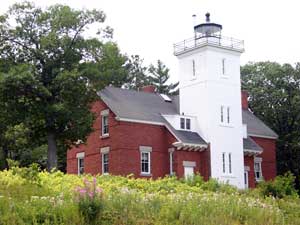
caption = Forty Mile Point Light
location =Presque Isle County ,Michigan
coordinates = coord|45|29|12|N|83|54|48|W
yearlit = 1897
automated = 1969
yeardeactivated =
foundation = Limestone
construction = Brick
shape = Square
marking = white w/black lantern
height = Tower - convert|52|ft|m
elevation = Focal plane - convert|66|ft|m
lens = Fourth orderFresnel lens
currentlens = Fourth orderFresnel lens
range = convert|16|mi|km
characteristic = white flash every 6 seconds. [ [http://www.navcen.uscg.gov/pubs/LightLists/V7COMPLETE.PDF Volume 7, US Coast Guard Lightlist (PDF).] ]
ARLHS = USA-303
USCG = 7-11715Forty Mile Point Light is a
lighthouse in NorthernMichigan , in Presque Isle County on Hammond Bay on the western shore ofLake Huron near Rogers CityUSA .Unlike many Great Lakes Lighthouses, Forty Mile Point Light does not mark a significant harbor or river mouth. Rather, it was constructed with the intent that as one sailed from Mackinaw Point to the Saint Clair river, one never was out of viewing range of a lighthouse. [ [http://www.detnews.com/apps/pbcs.dll/article?AID=/20080520/SPECIAL01/80519001 Detroit News, Interactive map on Michigan lighthouses.] ] With no river or harbor to use for a name, the light is named on the basis that it is convert|40|mi|km as the ship sails from Mackinaw Point.It is part of
U.S. Coast Guard District No. 9. [ [http://www.nps.gov/history/maritime/light/40mile.htm National Park Service, Maritime Heritage Project, 40 Mile Point Light.] ]History
While the Presque Isle
Peninsula had been lighted since 1840, and the entrance to theCheboygan River fifty miles to the north had been lighted since 1851, theNew Presque Isle Light 's range of visibility of convert|19|mi|km and theCheboygan Crib Light 's visible range of convert|13|mi|km left an unlighted convert|18|mi|km|sing=on intervening stretch of coastline along which mariners were forced to navigate blind. In its annual report for fiscal 1890, the Board recommended that $25,000 be appropriated for the construction of a new light and fog signal at Forty Mile Point near Hammond's Bay, at the approximate mid point between the two lights. [ [http://www.terrypepper.com/lights/huron/fortymile/fortymile.htm Terry Pepper, Seeing The Light - Forty Mile Point Lighthouse] ]Congress apparently was unimpressed with this request and it was 5 years before the concept was agreed to and funded. The plan for this light is nearly a clone of the plan for the
Big Bay Point Lighthouse onLake Superior being constructed at the same time. The penury of Congress concerning light stations on theGreat Lakes was not limited to Forty Mile Point. "See, e.g.,"Port Sanilac lighthouse .The footings are 20" limestone and the structure is 35' x 57'. The integrated tower is 12' square and 52' high. The house contains two identical apartments (probably for the keeper and the assistant keeper, but usually the assistant got a smaller, not an identical apartment). A unique feature is a skylight in the stairs so the keeper or his assistant could observe the light working without going outside or climbing the tower.
The light was completed in November 1896, but traffic on the Great Lakes is not a year round event, so it wasn't until the spring of 1897 that it was first lit. The station was automated in 1969 and is still operational. Foundation materials are wood pilings, and it is constructed of brick in a square shape. Markings are white with a black lantern. Another structure is attached to the tower. The original lens was a fourth order
Fresnel lens (pronounced [freɪ'nel] ) [ [http://www.uscg.mil/hq/g-cp/history/WEBLIGHTHOUSES/LHMI.html USCG's complete list and summary of Michigan lights, including facts and photographs.] ] designed and manufactured by Henry-Lepaute in Paris. It had six bulls-eye flash panels, and the clockwork would rotate it so that it would emit a white flash every ten seconds. [ [http://www.terrypepper.com/Lights/huron/fortymile/index.htm Terry Pepper, Seeing the Light - Forty Mile Point Light] ] The lens now in place is the third or fourth such lens to occupy that position. [ [http://www.40milepointlighthouse.org/lens.htm Lens, Forty Mile Lighthouse Society.] ]Current operations, maintenance, viewing and events
During the Big Blow of 1905, twenty-seven wooden vessels were lost. The steamer "Joseph S. Fay" ran aground, and a part of its hull rests on the beach approximately 200 feet north of the Lighthouse. there is a Michigan historical marker honoring Forty Mile Light, there is a marker concerning the "Graveyard of Ships." [ [http://www.michmarkers.com/Frameset.htm Michigan Historical Markers.] ] The marker states:
*Registered Historical Marker Site L2186 was erected 2007 Forty Mile Point Lighthouse / Graveyard of Ships. The Graveyard of Ships marker states:
**Named by seventeenth century French explorersLa Mer Douce the sweet or freshwater sea,Lake Huron is the second largest of the fiveGreat Lakes . It has over 3,800 miles of shoreline and contains 30,000 islands, among them Manitoulin, the world's largest freshwater island. Violent storms on the "sweet sea" have made it dangerous for ships. As of 2006, 1,200 wrecks had been recorded. During theBig Blow of 1905 , twenty-seven wooden vessels were lost. One of these, the steamer "Joseph S. Fay", ran aground. A portion of its hull rests on the beach approximately 200 feet north of the Forty Mile Lighthouse. TheGreat Storm of 1913 was responsible for sinking many modern ships. [ [http://www.michmarkers.com/Frameset.htm Michigan Historical Markers] ]Indeed, skeletons of ships are only a short distance from the light station. It is listed in the
National Register of Historic Places . National Register Reference #84001830 Name of Listing: FORTY MILE POINT LIGHT STATION (U.S. COAST GUARD/GREAT LAKES TR).It is in a county park (well-marked) convert|6|mi|km|sing=on north of Rogers City on , a/k/a the Sunrise Side Coastal Highway. A map with the lights in the area is available at [http://www.lighthousesrus.org/Maps/GL/HuronNE.htm lighthousesRus] . If you are going there, the park is accessible of from the highway -- do not turn on to 40 Mile Point road. [ [http://www.40milepointlighthouse.org Forty Mile Point Lighthouse Society.] ]
It is owned operated by the 40 Mile Point Lighthouse Society, and the grounds are open to the public year round from 10.00 AM to 10.00 PM. The lighthouse is open on weekends (Memorial Day through mid October). More information on hours may be obtained from the Rogers City Chamber of Commerce at (800) 622-4148.
Importantly, the many structures that were part of the installation remain:
lighthouse ;Lighthouse keeper quarters; bunkhouse (newly renovated in 2006-2007), [ [http://www.40milepointlighthouse.org/bunkhs.htm Bunkhouse photograph, Forty Mile Lighthouse Society.] ]foghorn signal building (thediaphone has been removed), oil house, and brickouthouse . The surrounding park also houses the wheelhouse of the first Calcite freighter. [ [http://lighthouse.boatnerd.com/gallery/Huron/40milepoint.htm Wobser, David, Boatnerd.com Forty Mile Point Light.] ]The fourth order
Fresnel lens is in place, and access to the tower provides a view of it and the Lakeshore. [ [http://www.terrypepper.com/Lights/huron/fortymile/index.htm Terry Pepper, Seeing the Light - Forty Mile Point Light.] ] This is a rarity, as few originally installed Fresnel lenses remain in use on the Great Lakes. ["See," [http://www.nps.gov/history/maritime/nhl/grossept.htm National Park Service Maritime Light Inventory, Grosse Point Light study] which disregards Forty Mile Point, and proffers a count of four remaining lenses -- it lists them -- on the Great Lakes.Sturgeon Point Light also has a lens in service and open to public view, and is not on the list. However, if may be that the article is only intending to list lights that have "their original lens in situ", and by that definition, Forty Mile Point and Sturgeon Point would not be on the list, as they have a replacement lens.]There are many recurrent events at the lighthouse. A calendar is available. [ [http://www.40milepointlighthouse.org Forty Mile Point Lighthouse Society.] ]
The lighthouse is now being used one half as a museum, and the other half as caretaker's quarters. [ [http://www.40milepointlighthouse.org Forty Mile Point Lighthouse Society.] ]
Membership in the 40-Mile Point Lighthouse Society is $20.00 per year, and the Society may be reached at:40 Mile Point Lighthouse Society, PO Box 205, Rogers City, MI 49779. [ [http://www.40milepointlighthouse.org Forty Mile Point Lighthouse Society.] ]
References
Bibliography and further reading
* [http://www.michiganlighthouse.org/bibliography.html Bibliography on Michigan lighthouses.]
* Crompton, Samuel Willard & Michael J. Rhein, "The Ultimate Book of Lighthouses" (2002) ISBN 1592231020; ISBN 978-1592231027.
* Hyde, Charles K., and Ann and John Mahan. "The Northern Lights: Lighthouses of the Upper Great Lakes." Detroit: Wayne State University Press, 1995. ISBN 0814325548 ISBN 9780814325544.
* Jones, Ray & Bruce Roberts, "American Lighthouses" (Globe Pequot, September 1, 1998, 1st Ed.) ISBN 0762703245; ISBN 978-0762703241.
* Jones, Ray,"The Lighthouse Encyclopedia, The Definitive Reference" (Globe Pequot, January 1, 2004, 1st ed.) ISBN 0762727357; ISBN 978-0762727353.
* Noble, Dennis, "Lighthouses & Keepers: U. S. Lighthouse Service and Its Legacy" (Annapolis: U. S. Naval Institute Press, 1997). ISBN 1557506388; ISBN 9781557506382.
* Oleszewski, Wes, "Great Lakes Lighthouses, American and Canadian: A Comprehensive Directory/Guide to Great Lakes Lighthouses", (Gwinn, Michigan: Avery Color Studios, Inc., 1998) ISBN 0-932212-98-0.
* Penrod, John, "Lighthouses of Michigan", (Berrien Center, Michigan: Penrod/Hiawatha, 1998) ISBN 9780942618785 ISBN 9781893624238.
*
* Putnam, George R., "Lighthouses and Lightships of the United States", (Boston: Houghton Mifflin Co., 1933).
*United States Coast Guard , "Aids to Navigation", (Washington, DC: U. S. Government Printing Office, 1945).
* [http://www.uscg.mil/History/weblighthouses/h_lhbib.asp United States Coast Guard, "Aids to Navigation Historical Bibliography".]
*
* Wagner, John L., "Michigan Lighthouses: An Aerial Photographic Perspective", (East Lansing, Michigan: John L. Wagner, 1998) ISBN 1880311011 ISBN 9781880311011.
* Wargin, Ed, "Legends of Light: A Michigan Lighthouse Portfolio" (Ann Arbor Media Group, 2006). ISBN 9781587262517.
* Wright, Larry and Wright, Patricia, "Great Lakes Lighthouses Encyclopedia" Hardback (Erin: Boston Mills Press, 2006) ISBN 1550463993ee also
*
Lighthouses in the United States External links
* [http://www.detnews.com/apps/pbcs.dll/article?AID=/20080520/SPECIAL01/80519001 Detroit News, Interactive map on Michigan lighthouses.]
* [http://www.40milepointlighthouse.org Forty Mile Point Lighthouse Society.]
* [http://www.lighthousesrus.org/HuronW.htm Interactive map, list, information for lighthouses in North and West Lake Huron.]
* [http://www.lighthousesrus.org/Maps/mapIt.htm?file=GL/HuronW.xml Interactive map of West Lake Huron, powered by Google.]
* [http://www.lighthousecentral.com/lighthouse_gallery.php4?lighthouse=Forty%20Mile%20Point%20Lighthouse Lighthouse Central, Forty Mile Point light "The Ultimate Guide to East Michigan Lighthouses" by Jerry Roach] (Publisher: Bugs Publishing LLC - July 2006).] ISBN 0974797715; ISBN 9780974797717.
* [http://www.unc.edu/~rowlett/lighthouse/miel.htm Lighthouse Digest, Forty Mile Point Light, University of North Carolina.]
* [http://www.lighthousefriends.com/macstraits.html Lighthouses in the Mackinac Straits.]
* [http://www.michiganlighthouse.org/Lighthouses/lighthouse_detail.php23.htm Michigan Lighthouse fund, Forty Mile Point.]
* Michigan.gov website has [http://www.michigan.gov/documents/hal_mhc_shpo_lightmap_50933_7.pdf Map of Michigan Lighthouses]
* [http://www.michmarkers.com/Frameset.htm Michigan Historical Markers.]
*National Park Service [http://www.nps.gov/history/maritime/light/40mile.htm Maritime Heritage Project, 40 Mile Point Light.]
* [http://www.terrypepper.com/Lights/huron/fortymile/index.htm Terry Pepper, Seeing the Light - Forty Mile Point Light.]
*United States Coast Guard [http://www.uscg.mil/history/weblighthouses/LHMI.asp 's complete list of Michigan lights, including Forty Mile Point.]
* [http://www.navcen.uscg.gov/pubs/LightLists/V7COMPLETE.PDF Volume 7, US Coast Guard Lightlist (PDF).]
* [http://www.us-lighthouses.com/displaypage.php?LightID=212 U.S. Lighthouses, Forty Mile Point Light.]
* [http://lighthouse.boatnerd.com/gallery/Huron/40milepoint.htm Wobser, David, Boatnerd.com Forty Mile Point Light.]
Wikimedia Foundation. 2010.