- Cheboygan Crib Light
-
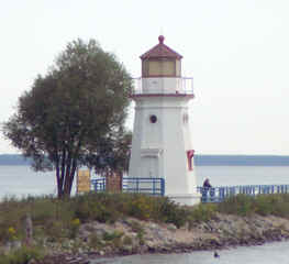
Cheboygan Crib Light 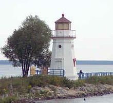
The light in 2001 Location Cheboygan, Michigan Coordinates 45°39.408′N 84°27.900′W / 45.6568°N 84.465°WCoordinates: 45°39.408′N 84°27.900′W / 45.6568°N 84.465°W Year first constructed 1884 Year first lit 1884 Foundation oak ring Construction cast iron Tower shape Octagonal and frustum of a cone Markings / pattern White tower with red lantern and trim Height Tower – 25 feet (7.6 m)[1] Focal height Focal plane – 35 feet (11 m)[2] Original lens Fourth-order Fresnel lens Current lens Fourth-order Fresnel lens[3] Range 10 miles (16 km) Characteristic Fl Red, 4 seconds[4] ARLHS number USA-160[5][6] The Cheboygan Crib Light is a light that marks the west pierhead of the mouth of the Cheboygan River into Lake Huron. The pierhead, in the center of the municipality of Cheboygan, is located at the north or lake end of Huron Street, and is one of the centerpieces of Cheboygan's Gordon Turner Park.[7]
Contents
History
1884-1920: manned light
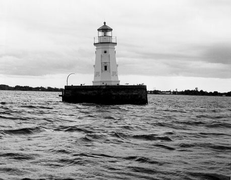
The Crib Light is called a "light" rather than a "lighthouse" because it does not contain a structure in which a keeper lived. The Light was originally built in Lake Huron in 1884 on a "crib", an artificial-island landfill,[8] more than 2,000 feet (610 m) from the Cheboygan shore. It is assumed that the keeper lived in Cheboygan; this would have required him to boat daily to the crib, despite weather conditions, to maintain the kerosene-fired light. This was hazardous duty, and in due course davits were installed on the Crib Light; this enabled a boat making dock at the crib to be raised, more easily unloaded, and be protected from the waves.[9]
In 1901 this station was painted white to increase its visibility as a daymark.
In 1903 Two years later, the wooden superstructure was removed and replaced with sturdier concrete. Iron railings were also installed to aid with safety; the railing was replaced after a schooner ran into the station.
In 1906 a fog bell was installed to help prevent such collisions. In 1911 an automated fog bell was installed, sounding a characteristic single stroke every ten seconds.[9]
In the 1920s, the light was automated. When last Lighthouse keeper left in 1929, it quickly degraded. "The light earned the nickname 'The Dummy'” from the locals."[10]
In 1903, the existing wooden structure was torn down to a depth of 12 inches (300 mm) into the water and a new sturdier concrete steel structure was erected. In 1906, the rebuilt light was severely damaged when a schooner hit it. In 1911 an automated fog bell was installed, sounding a characteristic single stroke every ten seconds.[9]
1920-present: automated light
In 1920, the Lighthouse Service oversaw the automation of the Crib Light. In the Crib Light's new incarnation, kerosene was no longer necessary; instead, a travelling crew periodically delivered tanks of the flammable gas acetylene. A reliable pilot light burned day and night. When the sun set, the resulting drop in temperature would open a precision valve and release a flow of acetylene against the pilot light, causing the light to shine.
In the second half of the 20th century, the invention of radar and other electronic aids to navigation began to render many Great Lakes navigational light towers redundant. The Crib Light was considered by the Coast Guard to be "surplus" property. In 1984, the Crib Light tower was removed from its crib and placed on its current base located on the Gordon Turner Park pierhead.[9][11][12]
As noted by a Coast Guard researcher:
The light earned the nickname “The Dummy” from the locals. When locals learned of the Coast Guard’s plans to demolish the site, an agreement was made to donate the light to the city of Cheboygan. The light was moved to the West Breakwall in the Gordon Turner Park. Restoration work has been done on the tower. The grounds are open to the public.[13]
The Cheboygan Crib Light is now maintained by the municipality of Cheboygan; the light itself, which is now powered by electricity, is maintained by a local support group. The light tower is considered by many to be a symbol of Cheboygan. In 2003, the municipality succeeded in clearing its title to the light and erasing its status as "surplus" property nominally under the ownership of the federal General Services Administration.[14]
It is not listed on the National Register of Historic Places or the state inventory.[3][11]
Location
The light is in Gordon Turner Park, which is located north of U.S. Highway 23 in Cheboygan, just west of the Cheboygan River. The park is at the end of Huron Street for less than one mile (1.6 km) north of the highway. The park's boardwalk leads to the Cheboygan River and the light. The light may also been viewed from eastbound lighthouse cruises offered by Shepler's Ferry out of Mackinaw City.[15][16]
It is not lighted at this time. Visitors to Gordon Turner Park can view and walk around the light at the end of Water Street in Cheboygan.[15] A few blocks upriver is the Cheboygan River Front Range Light.[13]
References
- ^ Pepper, Terry. "Database of Tower Heights". Seeing the Light. terrypepper.com. http://www.terrypepper.com/lights/lists/towers.htm.
- ^ Pepper, Terry. "Database of Focal Heights". Seeing the Light. terrypepper.com. http://www.terrypepper.com/lights/lists/focalheight.htm.
- ^ a b National Park Service, Maritime Heritage Project, Inventory of Lights, Cheboygan Crib Light.
- ^ (PDF) Light List, Volume VII, Great Lakes. Light List. United States Coast Guard. http://www.navcen.uscg.gov/pdf/lightLists/LightList%20V7.pdf.
- ^ Amateur Radio Lighthouse Society, Cheboygan Crib (Lake Huron) Light ARLHS USA-160
- ^ Amateur Radio Lighthouse Society, World List of Lights.
- ^ Rowlett, Russ. "Lighthouses of the United States: Michigan's Eastern Lower Peninsula". The Lighthouse Directory. University of North Carolina at Chapel Hill. http://www.unc.edu/~rowlett/lighthouse/miel.htm.
- ^ Michigan Lighthouse Fund, Cheboygan Crib Light.
- ^ a b c d Terry Pepper, Seeing the Light, Cheboygan Crib Light.
- ^ "Historic Light Station Information and Photography: Michigan". United States Coast Guard Historian's Office. http://www.uscg.mil/history/weblighthouses/LHMI.asp.
- ^ a b Michigan Lighthouse Conservancy, Cheboygan Crib Light.
- ^ Lighthouse Central, Cheboygan Crib light The Ultimate Guide to East Michigan Lighthouses by Jerry Roach (Publisher: Bugs Publishing LLC - July 2006). ISBN 0974797715; ISBN 9780974797717.
- ^ a b Wobser, David, Cheboygan Crib Light, boatnerd.com.
- ^ Sanderson, Dan, Traverse City Record Eagle, "City will finally own light; Most thought they already did own it" July 27, 2003.
- ^ a b Anderson, Kraig, Lighthouse Friends, Cheboygan Crib Light.
- ^ "Sheplers Ferry, Lighthouse Cruises.". http://www.sheplersferry.com/lighthouses/lighthouses.html.
External links
 Vintage image of the light (on its crib and before being moved)
- Barnes, Skip, recent photo of Cheboygan Crib Light.
- Detroit News, Interactive map on Michigan lighthouses.
- The Great Lakes Lighthouse Keepers Association.
- Interactive map of Lighthouses in the area.
- Interactive map, list, information for lighthouses in North and West Lake Huron.
- Map of Michigan Lighthouses.
- Terry Pepper, Seeing the Light, Cheboygan Crib Light.
Lighthouses of Michigan See also: List of lighthouses in Michigan Northern upper peninsula Au Sable Light • Big Bay Point Light • Copper Harbor Light • Copper Harbor Front Range Light • Crisp Point Light • Eagle Harbor Light • Eagle Harbor Range Lights • Eagle River Light • Fourteen Mile Point Light • Grand Island East Channel Light • Grand Island Harbor Rear Range Light • Grand Island North Light • Granite Island Light • Gull Rock Light Station • Huron Island Light • Isle Royale Light • Manitou Island Light Station • Marquette Harbor Light • Mendota (Bete Grise) Light • Munising Front Range Light • Munising Rear Range Light • Portage River (Jacobsville) Light • Passage Island Light • Rock Harbor Light • Rock of Ages Light • Sand Hills Light • St. Martin Island Light • Stannard Rock Light • Thunder Bay Island Light • Whitefish Point LightSouthern upper peninsula DeTour Reef Light • Manistique East Breakwater Light • Martin Reef Light • Menominee Pier Light • Naubinway Island Light • Peninsula Point Light • Poverty Island Light • Sand Point Light Escanaba • Sand Point Light Baraga • Seul Choix Light • Squaw Island Light • White Shoal LightSt. Mary's River Frying Pan Island Light • Pipe Island Light • Point Iroquois Light • Round Island Light (St. Mary's River) • Six Mile Point Range Rear LightPortage River/Ship Canal Keweenaw Waterway (Portage Lake) Lower Entrance • Keweenaw Waterway Upper Entrance Light • Rouleau Point Range Front and Rear LightsStraits of Mackinac Bois Blanc Light • McGulpin Point Light • Old Mackinac Point Light • Round Island Light • Round Island Passage • St. Helena Island LightWestern lower peninsula Beaver Island Harbor Light • Beaver Island Head Light • Big Sable Point Light • Charlevoix Light • Charlevoix South Pier Light • Frankfort Light • Frankfort South Range Light • Grand Haven Light • Grand Haven South Pierhead Outer Light • Grand Haven Main Light • Gray's Reef Light • Holland Harbor Light • Ile Aux Galets • Little Sable Point Light • Little Traverse Light • Ludington Light • Manistee Main Light • Manistee Pierhead lights • Miller Memorial Light • Mission Point Light • Mission Point Light (2) • Muskegon Breakwater Light • Muskegon Pier Light • Point Betsie Light • South Fox Island • South Haven Light • South Manitou Island Light • Waugoshance Light • White River LightEastern lower peninsula Alpena Light • Bellanger Park (Ecorse) Light • Caseville Harbor (Saginaw Bay) • Belle Isle Light • Charity Island Light • Cheboygan River Range Front Light • Cheboygan Crib Light • Detroit River Light • Fort Gratiot Light • Forty Mile Point Light • Fourteen Foot Shoal Light • Gibraltar Light • Gravelly Shoal Light • Harbor Beach Light • Manning Memorial Light • Mariners Memorial (River Rouge) Light • New Presque Isle Light • Old Presque Isle Light • Poe Reef Light • Pointe aux Barques Light • Port Austin Light • Port Sanilac Light • Saginaw River Range Front Light • Saginaw River Rear Range Light • Spectacle Reef Light • St. Clair Flats Front and Rear Range Light • Sturgeon Point Light • Tawas Point Light • Tri-Centennial Light of Detroit • William Livingtone Memorial LightHistorical (lost) lights Au Sable North Pierhead • Clinton River Light • Ecorse Light • Ecorse Range Rear • Gibraltar Light • Grassy Island Lighthouse • Grassy Island North Channel Range • Grassy Island South Channel Range • Grosse Isle South Channel Range • Harwood Point East Range Front (St. Mary's River) • Mama Juda Light • Mama Juda Range Front • Middle Lake George • Monroe Pier • New Buffalo • North Manitou Island • Rouleau Point Range Front and Rear • Saginaw Bay • Sand Beach North Entrance East • Squaw Point • St. Mary's River Lower Range Front • Turtle Island Light • Vidal Shoals Channel Range Front and Rear • Windmill Point Range Front and Rear • Winter Point Range FrontRelated – Lightship Huron, List of lifesaving stations in Michigan Categories:- Lighthouses in Michigan
- Buildings and structures in Cheboygan County, Michigan
- Visitor attractions in Cheboygan County, Michigan
Wikimedia Foundation. 2010.