- Auckland Harbour Bridge
Infobox Bridge
bridge_name = Auckland Harbour Bridge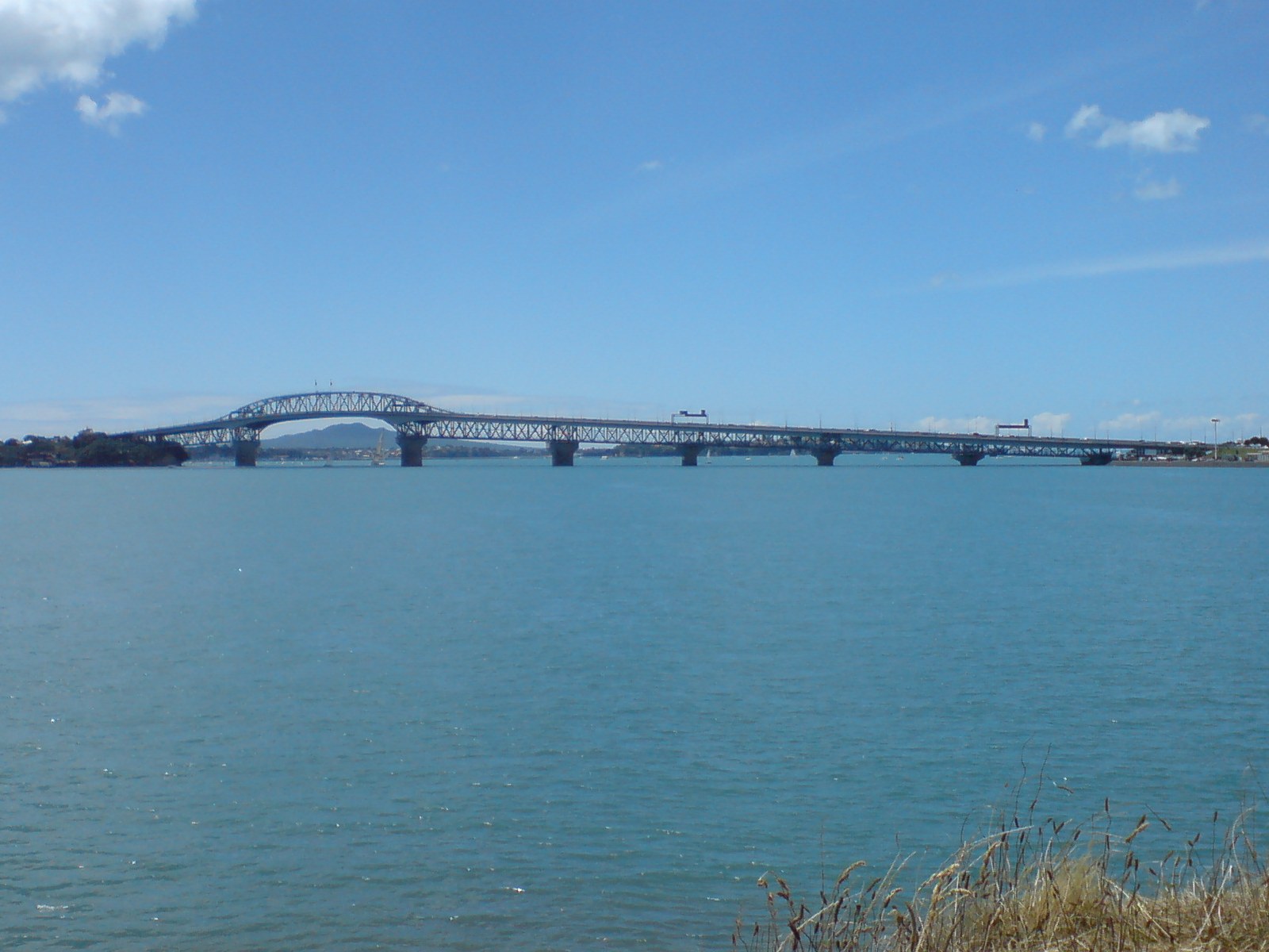
caption = The bridge fromWatchman Island , west of it.
official_name =
carries = Motor vehicles
crosses =Waitemata Harbour
locale =Auckland City /North Shore City ,New Zealand
maint =Transit New Zealand
id =
designer = Freeman & Fox
design =Box truss
material =Steel
spans =
pierswater =
mainspan = 243.8 metres
length = 1,020 metres (3,348 ft)
width =
height =
load =
clearance =
below = 43.27 metres at high tide
traffic = 168,754
begin =
complete =
open =30 May 1959
closed =
toll = Until 1984
map_cue =
map_
map_text =
map_width =
coordinates =
lat =
long =The Auckland Harbour Bridge is an eight-lane box truss motorway bridge over the
Waitemata Harbour , joining St Marys Bay in Auckland with Northcote inNorth Shore City ,New Zealand . The bridge is part of State Highway 1 and theAuckland Northern Motorway . It is the second-longest road bridge in New Zealand, and the longest in theNorth Island . [ [http://www.transit.govt.nz/about/faqs.jsp#31 What is the longest bridge in New Zealand?] (from theTransit New Zealand FAQ webpage. Accessed2008-06-09 .)]The bridge has a length of 1,020 m (3,348 ft), with a main span of 243.8 m, rising 43.27 m above high water [ [http://www.transit.govt.nz/content_files/AHB/1951-1961.pdf 1951-1961 The Auckland Harbour Bridge Authority] (
Auckland Harbour Board publication, 1960s)] allowing access to the deepwater port at theChelsea Sugar Refinery west of it (nowadays one of the few wharves needing such access west of the bridge).Background
Prior to construction of the bridge, the quickest way from Auckland to the North Shore was via passenger or vehicular ferry. By road, the shortest route was through West Auckland via Riverhead and Albany, over 40 kilometres.
Construction
Initial structure
The bridge took four years to build. The large steel girder sections were partially pre-assembled, and then floated into place on construction barges. On of the main spans was almost lost during stormy weather when the barge began to drift, but the tugboat "
William C Daldy " won a 36-hour tug-of-war against the high winds. ["References provided within theWilliam C Daldy article."]The bridge was opened officially on
May 30 ,1959 by the Governor-General Lord Cobham [ [http://www.youtube.com/watch?v=M3Tu1WbjN1I&eurl Auckland - Our Bridge] (historical video viaYouTube . Accessed 2008-07-27.)] ["Record of 20 Years Activities 1951-1971" - Auckland Harbour Bridge Authority] , with four lanes of traffic, two in each direction. Four men were killed during construction, and their names are recorded on a memorial plaque underneath the bridge at the Northcote end.Fact|date=August 2008The bridge started out as a
toll bridge , with toll booths for both north and south-bound traffic located at the northern end. Tolls were originally 2/6 (25 cents) per car but were reduced to 2/- (20 cents) after 15 months of operation. Later tolling was made south-bound only before being discontinued onMarch 30 ,1984 , and the booths removed. [http://www.shorelibraries.govt.nz/Topics/Heritage/HarbourBridge/Slide15.php Bridging the Gap, Slide 15] (from the North Shore City Libraries website. Accessed 2008-06-08.)] This was in line with political commitments that tolls would only be charged until the bridge's construction costs were paid off.'Nippon clip-ons'
The bridge was originally built with four lanes for traffic. Owing to the rapid expansion of suburbs on the North Shore and increasing traffic levels it was necessary to increase the capacity of the bridge.
In 1969 two-lane box girder clip-on sections were added to each side, doubling the number of lanes to eight. The sections were manufactured by Japanese contractors (Ishikawajima-Harima Heavy Industries), which led to the nickname 'Nippon clip-ons'. The selection of the company was considered a bold move at the time, barely 20 years after WWII and with some considerable anti-Japanese sentinemt still existing in the country. [http://www.shorelibraries.govt.nz/Topics/Heritage/HarbourBridge/Slide14.php Bridging the Gap, Slide 14] (from the North Shore City Libraries website. Accessed 2008-06-08.)]
In 2006, it became public that cracks and signs of material fatigue had been found in the clip-on lanes, which have an expected lifetime of 50 years.Fact|date=October 2007 Auckland City Council Transport Committee requested Transit New Zealand to investigate the future of the clip-on lanes as part of its 10-year plan. Transit noted in this context that the plan already includes some funding for bridge maintenance." [http://tvnz.co.nz/view/page/680360 Harbour Bridge future questioned] " -
Television New Zealand , Sunday12 March 2006 ]In May 2007, Transit New Zealand proposed a bylaw change to restrict trucks over 4.5 tonnes from using the outside lane on each clip-on to reduce stress on the aging structure." [http://tvnz.co.nz/view/page/488120/1096925 Trucks to be banned from clip-ons] " -
Television New Zealand , Friday4 May [2007] ] This was later changed to a bylaw introduced in July 2007 restricting only vehicles of 13 tonnes or more, based on the high level of voluntary compliance during the previous months. [" [http://www.nzherald.co.nz/category/story.cfm?c_id=97&objectid=10451948 Transit bans large trucks from clip-ons to extend life of lanes] " - "The New Zealand Herald ", Tuesday17 July 2007 ]In 2007, it was announced that NZ$45 million in maintenance work on the clip-on sections was being pulled ahead as part of good practice. In October 2007 a 2006 report from
Beca Group surfaced in the press, noting that the clip-ons were at risk of catastrophic, immediate failure in certain circumstances (such as a traffic jam trapping a large number of trucks on them). Transit New Zealand has noted that the situation described was extremely unlikely, and measures already implemented would prevent it from occurring. [" [http://www.nzherald.co.nz/section/1/story.cfm?c_id=1&objectid=10469771 'Catastrophic failure' warning on Harbour Bridge] " - "The New Zealand Herald ", Sunday14 October 2007 ]Traffic management
A "tidal flow" system is in place, where the traffic direction of two of the centre lanes is changed in order to provide an additional lane for peak period traffic. During the morning rush five of the eight lanes are allocated to southbound traffic, heading towards Auckland. This situation is reversed in the afternoon, when five lanes are allocated to northbound traffic. At all other times of the day the lanes are split evenly, and peaks also have grown increasingly evenly distributed (i.e. in 1991 there was often a higher than 3:1 difference in directional traffic, in 2006 this had dropped to around 1.6:1). The bridge has an estimated vehicle capacity of 180,000 per day, and in 2006 had an average volume of 168,754 vehicles per day (up from 122,000 in 1991)." [http://www.nzherald.co.nz/section/1/story.cfm?c_id=1&objectid=10450836 Traffic Decline casts shadow on $3b tunnel] " - "
The New Zealand Herald ", Wednesday11 July 2007 ]For many years lane directions were indicated by overhead signals. In the late 1980s a number of fatal head-on accidents occurred when vehicles crossed lane markings into the path of oncoming traffic. In the 1990s, a movable concrete safety barrier was put in place to separate traffic heading in opposite directions and eliminate head-on accidents. A specially designed barrier machine moves the barrier by one lane four times a day, [http://www.shorelibraries.govt.nz/Topics/Heritage/HarbourBridge/Slide16.php Bridging the Gap, Slide 16] (from the North Shore City Libraries website. Accessed 2008-06-08.)] at a speed of 6 km/h. It takes 40 minutes to move the entire barrier.
Proposed Walkway and Cycleway
When the bridge was built the originally envisaged walking and cycling paths were dropped for cost reasons,Fact|date=September 2008 and neither were they included during the clip-on construction (tourists can walk on the span via guided tours). In recent (2007) discussions about the future of the bridge, the addition of a cycle and footpath link between Auckland City and North Shore City has been mooted for the bridge. Transit New Zealand has noted that such a provision would cost between NZ$20 and 40 million, but public support for such an addition to the bridge has been polled as being very high. [" [http://www.nzherald.co.nz/topic/story.cfm?c_id=214&objectid=10482289 Cycle, walking lane on bridge wins support] " - "
The New Zealand Herald ", Friday14 December 2007 ]Cycle Action Auckland meanwhile notes that lower-cost options are available, and that a cycleway could relatively easily be included in the bridge strengthening works currently being planned for the clip-on structure.Cycle Action Auckland has [http://getacross.org.nz/ created a webpage] showcasing the proposed walking/cycling solution and invites visitors to sign a petition supporting or opposing the proposal. [" [http://www.nzherald.co.nz/section/1/story.cfm?c_id=1&objectid=10496427 Bike campaigners find more room on bridge] " - "
The New Zealand Herald ", Thursday6 March 2008 ]A 2008 proposal to modify the clip-ons and potentially widen them to add walking- and cycling paths to the bridge met with different reactions. While
Auckland Regional Council andNorth Shore City Council voted to support it (under certain conditions),Auckland City Council considered the costs associated with the proposal as too high. Other stakeholders such as the NZ Transport Agency had still to make their decision in September 2008, and the fate of the proposal is uncertain. [" [http://www.nzherald.co.nz/mathew-dearnaley/news/article.cfm?a_id=111&objectid=10531781 Shore says conditional yes to path for bridge] " - "The New Zealand Herald , Friday12 September 2008 ]econd Harbour Crossing
Almost since the Harbour Bridge reached capacity (i.e. before extension via the clip-ons) a second crossing of the harbour was mooted. The extreme costs and the difficulties of connecting it to the motorway network have however so far caused plans to remain at concept stage. However, in 2008, a study group narrowed down around 160 options to a single recommendation, a multi-tunnel link approximately one km east of the existing bridge, with up to four individual tunnels for motorway and public transport and trains. The proposal however has not continued to a political decision or funding stage.
ee also
;General:
*Public transport in Auckland
*Transport in Auckland ;Specific:
*Central Motorway Junction , the major motorway junction connecting southeast of the bridge
*Newmarket Viaduct , similarly important traffic bottleneck on other side of Auckland CBD
*Western Reclamation , large industrial area east of the bridge, possible site of 2nd crossingReferences
External links
*
* [http://cmi.transit.govt.nz/html/cmi/history.htm Historical photos] (from theTransit New Zealand website)
* [http://www.bioeng.auckland.ac.nz/people/autumn/pix/history/historical_auckland.htm Historical photos] (from a private website)
* [http://getacross.org.nz/ Get Across] (Cycle Action Auckland website promoting a Harbour Bridge cycling facility)
Wikimedia Foundation. 2010.