- Lepontine Alps
Geobox|Range
name=Lepontine Alps
other_name= _fr. Alpes lépontines
other_name1= _de. Lepontinische Alpen
other_name2= _it. Alpi Lepontine
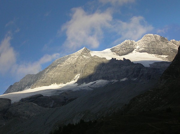
image_caption=Monte Leone
country=Switzerland | country1=Italy
region=Valais| region1=Ticino| region2=Graubünden| region3=Piedmont
unit=Alps
border=Bernese Alps| border1=Urner Alps|border2=Pennine Alps
border3=Glarus Alps|border4=Oberhalbstein Range
geology= |period= |orogeny=
length_imperial=| length_orientation=
width_imperial= | width_orientation=
geology= | period= | orogeny=
highest=Monte Leone
highest_elevation=3552
highest_lat_d=46|highest_lat_m=24|highest_lat_s=|highest_lat_NS=N
highest_long_d=8|highest_long_m=08|highest_long_s=|highest_long_EW=E
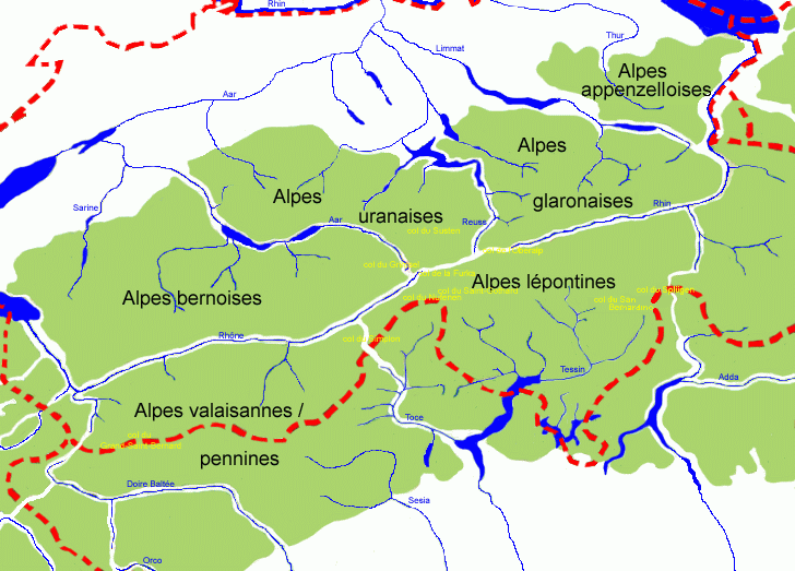
map_caption=Central AlpsThe Lepontine Alps are amountain range in the central part of theAlps . They are located inSwitzerland (Valais ,Ticino andGraubünden ) andItaly (Piedmont ). TheFurka Pass , St Gotthard Pass and the upper Rhône valley separate them from theBernese Alps ; the upper Rhône valley separates them from theUrner Alps ; theSimplon Pass separates them from thePennine Alps ; the Vorderrhein valley and theOberalp Pass separate them from theGlarus Alps ; theSplügen Pass separates them from theCentral Eastern Alps (Oberhalbstein Range ).The Lepontine Alps are drained by the rivers Rhône in the west, Reuss in the north,
Rhine (Vorderrhein and Hinterrhein) in the east and Ticino andToce in the south.The Simplon rail tunnel, which leads from Brig to
Domodossola , the St Gotthard rail and highway tunnels (fromAndermatt toAirolo ) and the San Bernardino Tunnel are important transport arteries.The eastern portion of the Lepontine Alps, from the St Gotthard Pass to the
Splügen Pass , is sometimes named the Adula Alps.List of peaks
The chief peaks of the Lepontine Alps are:
Name Elevation m ft Monte Leone 3,561 11,684 Rheinwaldhorn 3,402 11,149 Güferhorn 3,393 11,132 Blinnenhorn 3,384 11,103 Basodino 3,276 10,749 Pizzo Tambo 3,276 10,749 Helsenhorn 3,274 10,742 Wasenhorn 3,255 10,680 Ofenhorn 3,242 10,637 Scherbadung 3,213 10,542 Piz Medel 3,203 10,509 Scopi 3,200 10,499 Pizzo Rotondo 3,197 10,489 Piz Terri 3,151 10,331 Piz Aul 3,124 10,250 Pizzo Pesciora 3,120 10,247 Witenwasserenstock 3,084 10,119 Campo Tencia 3,075 10,089 Leckihorn 3,069 10,069 Bruschghorn 3,054 10,020 Alperschällihorn 3,045 9,991 Chilchalphorn 3,040 9,974 Piz Blas 3,023 9,918 Monte Giove 3,010 9,876 Pizzo Centrale 3,003 9,853 Pizzas d'Anarosa 3,002 9,850 Piz Beverin 2,998 9,843 Weisshorn (Splugen) 2,992 9,817 Pizzo Lucendro 2,959 9,708 Piz Tomul 2,949 9,676 Piz Cavel 2,944 9,659 Barenhorn 2,932 9,620 Six Madun (Badus) 2,932 9,619 Piz Muraun 2,899 9,512 Zervreilahorn 2,898 9,508 Monte Cistella 2,851 9,353 Piz Lukmanier 2,778 9,115 Monte Prosa 2,738 8,983 Pizzo Columbe 2,549 8,363 Camoghè 2,226 7,303 Piz Mundaun 2,065 6,775 Monte Generoso 1,704 5,591 Monte San Salvatore 916 3,004 List of passes
The chief passes of the Lepontine Alps are:
Mountain pass location type elevation m ft Zapport Pass Hinterrhein to Malvaglia andBiasca snow 3,079 10,103 Guferlücke Canaltal to Lentatal (near Vals, Switzerland )snow 2,980 9,777 Lentalücke Hinterrhein to Vals snow 2,954 9,692 Hohsand Pass Binn toLa Frua (Toce waterfalls)snow 2,927 9,603 Lecki Pass Realp toOberwald VS snow 2,912 9,554 Passo Rotondo Airolo to Oberwaldsnow 2,880 9,449 Kaltwasser Pass Simplon Hospice toAlpe Veglia snow 2,844 9,331 Scaradra Pass Vals to Olivone foot path 2,770 9,088 Satteltelücke Vals to Vrin foot path 2,768 9,082 Ritter Pass Binn to Alpe Vegliasnow 2,692 8,832 Cavanna Pass Realp toBedretto snow 2,611 8,566 Scatta Minoja Devero toFormazza bridle path 2,597 8,521 Bocca di Cadlimo Airolo to the Lukmanier Pass foot path 2,542 8,340 Valserberg Hinterrhein to Vals bridle path 2,507 8,225 Safierberg Splügen to Safien bridle path 2,490 8,170 Nufenen Pass Ulrichen to Airolo road 2,478 8,130 Geisspfad Pass Binn to Devero foot path 2,475 8,120 Gries Pass Ulrichen to La Fruabridle path 2,468 8,098 Passo di Naret Fusio to Airolobridle path 2,443 8,015 Passo Valtendra Alpe Veglia to Devero and Baceno bridle path 2,431 7,976 Diesrut Pass Vrin to Somvix bridle path 2,424 7,953 Albrun Pass Binn to Devero and Baceno bridle path 2,410 7,907 Greina Pass Olivone to Somvix bridle path 2,360 7,743 San Giacomo Pass Airolo to La Frua bridle path 2,308 7,573 Passo di Buffalora Mesocco to theVal Calanca foot path 2,265 7,431 Passo dell'Uomo Quinto, Switzerland to theLukmanier Pass bridle path 2,212 7,258 Splügen Pass Thusis toChiavenna road 2,117 6,946 St Gotthard Pass Andermatt to Airoloroad 2,114 6,936 San Bernardino Pass Thusis to Bellinzona road 2,063 6,769 Lukmanier Pass Disentis to Olivoneroad 1,917 6,289 ee also
*
Swiss Alps References
*1911
Wikimedia Foundation. 2010.