- Patillas, Puerto Rico
Infobox Settlement
settlement_type =
subdivision_type = Country
subdivision_name =United States
subdivision_type1 = Territory
subdivision_name1 =Puerto Rico
subdivision_type2 =
subdivision_name2 =
timezone=AST
utc_offset=-4
timezone_DST=
utc_offset_DST=
unit_pref=Imperial
map_caption =Location of Patillas, Puerto Rico within Puerto Rico.
latNS=N
longEW=W| official_name = Patillas, Puerto Rico | nickname = La Esmeralda del Sur", "Los Melones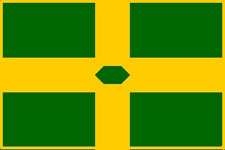
image_
| population_blank1 = Patillenses|population_blank1_title=Gentilic| | population_blank1 = Patillenses|population_blank1_title=Gentilic|
| map_caption = Location within the island ofPuerto Rico
established_date = 1811 | leader_title|established_title=Founded| =Mayor | leader_title=Mayor
leader_name = Hon. Roberto Ramos
political party = Partido Popular Democratico
leader_party = PPD
leader_title1=Senatorial dist.
leader_name1= 7 - Humacao
leader_title2=Representative dist.
leader_name2 = 34| area_magnitude = | area_total_km2 = 153.62
area_land_km2 = 125| area_water_km2 = 28.62| population_as_of = 2000 | population_note =
population_total = 21843|population_footnotes= | population_density_km2 = 163.9| timezone = AST | utc_offset = -4 | timezone_DST = | utc_offset_DST = -4| latd= |latm= |lats=
longd=|longm= |longs=
latitude =
longitude =
website =
footnotes = Anthem – "Patillenses" |Patillas (pah-TEE-yahs) is a
municipality ofPuerto Rico located in the southeastern coast, south of San Lorenzo; west of Yabucoa and Maunabo; and east of Guayama and Arroyo. It is spread over 15 wards and Patillas Pueblo (thedowntown area and the administrative center of the city).History
During the mid-18th century there already existed a relatively large number of dispersed neighbors in the
Valley of Patillas and along thesoutheast ern coast of the island of Puerto Rico. During this time frame, there was an establishment of asugar cane mill which took advantage of the agricultural potential the valley provided. As this establishment provided a good source ofincome for the neighbors it also was the main reason for the town's foundation in 1811. Mrs. Adelina Cintrón, owner of "La Finca Patillas", donated almost convert|8|acre|m2 of land for the foundation. Most of the neighbors then relocated towards the west side of the proposed site called "Cacao Bajo". The name "Patillas" is originally an indigenous name for a native type ofwatermelon . The large abundance of this fruit in the area, along with the land donation from the original owner, lead for the town's name.Flag
Design
The art design was a creation of Pedro de Pedro in 1977. Each symbol on the flag was defined by Pedro J. Rivera Arbolay. The legal assessor was the LicenciadoRoberto Beascochea Lota .Description
Four greenrectangle s on the corners symbolize thevalley s andmountain s of this great town. These rectangles are separated by a golden cross simbolizing the fidelity towards the town's religious patron "El Santo Cristo de la Salud". Superimposed in the middle of the golden cross is anemerald , thus thenickname "La Esmeralda del Sur".Coat of Arms
The
crow with a piece ofbread in itsbeak , bird that saves the life to San Benito Abad, patron of the town, from beingpoison ed with a piece of bread. Thecastle with threewindow s symbolizes the captivity of Santa Barbara, matron of Patillas in the first years of the foundation and the devotion to the Santísima Trinidad. The cross represents Santo Cristo de la Salud. The two crossed machetes underneath the cross represent thepeasant s' struggle in the sugar cane plantations and the origins of [economic development . The three towers in the superior part mean that Patillas is categorized as a town. The watermelon leaf, fruit that abounded in the west of Patillas, is the reason for the name of the town. The motto "Ora Et Labora", means Pray and Work; motto of the religious order of San Benito Abad.Demographics
Barrios (Districts/Wards)
*Apeadero
*Bajo
*Cacao Alto
*Cacao Bajo
*Egozcue
*Guardarraya
*Higueros
*Jacaboa
*Jagual
*Mamey
*Marín
*Mulas
*Muñoz Rivera
*Pollos
*Providencia
*Quebrada Arriba
*El Real
*Ríos
*Mamey Chiquito
*Recio
*El BajoGeo/Topography
*Gorges are: Barros, Colones, Farallón, Guano, Hicacos, Hormiga , Mulas, Quebrada Arriba and Sonadora.
*Rivers are: Chico, Grande de Patillas,Jacaboa and MarínAnthem
Patillenses By Andrés Plaud Soto (April 1985)
Patillenses, ¡Veis la luz,
de la antorcha y su esplendor,
que ilumina en noble gesta de amor...
la ruta que recorrió,
el que por ti ayer luchó,
en las lides de los campos del honor!No olvidéis otras proezas
en las Artes del Saber,
producto de otros hermanos,
que este pueblo vio nacer.Sus conquistas celebramos
con solemne admiración:
¡Hosana mis compueblanos...
Les brindo mi corazón!Economic
Agriculture
Business
Industrial
Tourism
Tourist sector is currently in development.
Landmarks and places of interest
*Charco Azul (lake)
*Charco Los Tres Chorros (lake)
*Carite-Guavate Forest
*Escondida Beach
*Guardarraya Beach
*Charco de la vuelta
*Villa pesquera Beach
*Lago de Patillas
*Guavate forest and place to eatFestivals and events
*Patron Celebrations - March
*Emerald of the South Carnival - April
*Monte y Mar Festival - July
*Flour Festival - December
*Ñame Festival - DecemberTransportation
Education
ports
Emilio "Millito" Navarro (born
September 26 ,1905 in the city of Patillas, Puerto Rico) was the first Puerto Rican to play baseball in theNegro Leagues .Notable "Patillenses"
*
Edmundo Disdier —Musician and composer
*Ramón Lebrón — First secretary of the court
*Sigfredo Badillo Rivero —Poet References
Footnotes
Books about Patillas
Additional Information
Photo gallery
External links
Wikimedia Foundation. 2010.